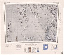
The geography of Antarctica is dominated by its south polar location and, thus, by ice. The Antarctic continent, located in the Earth's southern hemisphere, is centered asymmetrically around the South Pole and largely south of the Antarctic Circle. It is washed by the Southern Ocean or, depending on definition, the southern Pacific, Atlantic, and Indian Oceans. It has an area of more than 14.2 million km2. Antarctica is the largest ice desert in the world.

A volcano is a rupture in the crust of a planetary-mass object, such as Earth, that allows hot lava, volcanic ash, and gases to escape from a magma chamber below the surface. The process that forms volcanoes is called volcanism.

Gaussberg is an extinct, 370-metre-high (1,210-foot) high volcanic cone in East Antarctica fronting on Davis Sea immediately west of Posadowsky Glacier. It is ice-free and conical in nature, having formed subglacially about 55,000 years ago. The current edifice is thought to be the remains of a once-larger mountain that has been reduced by glacial and subaerial erosion. The volcano has produced lamproite magmas, and is the youngest volcano to have produced such magmas on Earth.

Mount Hampton is a shield volcano with a circular ice-filled caldera. It is a twin volcano with Whitney Peak to the northwest and has erupted phonolite rocks. It is the northernmost of the volcanoes which comprise the Executive Committee Range in Marie Byrd Land, Antarctica and was active during the Miocene.

Mount Melbourne is a 2,733-metre-high (8,967 ft) ice-covered stratovolcano in Victoria Land, Antarctica, between Wood Bay and Terra Nova Bay. It is an elongated mountain with a summit caldera filled with ice with numerous parasitic vents; a volcanic field surrounds the edifice. Mount Melbourne has a volume of about 180 cubic kilometres (43 cu mi) and consists of tephra deposits and lava flows; tephra deposits are also found encased within ice and have been used to date the last eruption of Mount Melbourne to 1892 ± 30 years. The volcano is fumarolically active.

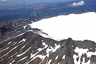
Mount Morning is a shield volcano at the foot of the Transantarctic Mountains in Victoria Land, Antarctica. It lies 100 kilometres (62 mi) from Ross Island. Mount Morning rises to an elevation of 2,723 metres (8,934 ft) and is almost entirely mantled with snow and ice. A 4.1 by 4.9 kilometres wide summit caldera lies at the top of the volcano and several ice-free ridges such as Hurricane Ridge and Riviera Ridge emanate from the summit. A number of parasitic vents mainly in the form of cinder cones dot the mountain.
Mount Moulton is a 40-kilometre-long (25 mi) complex of ice-covered shield volcanoes, standing 25 kilometres (16 mi) east of Mount Berlin in the Flood Range, Marie Byrd Land, Antarctica. It is named for Richard S. Moulton, chief dog driver at West Base. The volcano is of Pliocene age and is presently inactive.

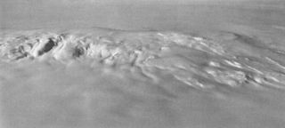
Mount Takahe is a 3,460-metre-high (11,350 ft) snow-covered shield volcano in Marie Byrd Land, Antarctica, 200 kilometres (120 mi) from the Amundsen Sea. It is a c. 30-kilometre-wide (19 mi) mountain with parasitic vents and a caldera up to 8 kilometres (5 mi) wide. Most of the volcano is formed by trachytic lava flows, but hyaloclastite is also found. Snow, ice, and glaciers cover most of Mount Takahe. With a volume of 780 km3 (200 cu mi), it is a massive volcano; the parts of the edifice that are buried underneath the West Antarctic Ice Sheet are probably even larger. It is part of the West Antarctic Rift System along with 18 other known volcanoes.

Mount Waesche is a mountain of volcanic origin at the southern end of the Executive Committee Range in Marie Byrd Land, Antarctica. It is 3,292 metres high, and stands 20 kilometres southwest of Mount Sidley, the highest volcano in Antarctica. The mountain lies southwest of the Chang Peak caldera and is largely covered with snow and glaciers, but there are rock exposures on the southern and southwestern slopes.

Several types of volcanic eruptions—during which material is expelled from a volcanic vent or fissure—have been distinguished by volcanologists. These are often named after famous volcanoes where that type of behavior has been observed. Some volcanoes may exhibit only one characteristic type of eruption during a period of activity, while others may display an entire sequence of types all in one eruptive series.
Melimoyu is a stratovolcano in Chile. It is an elongated volcanic complex that contains two nested calderas of 1 kilometre (0.62 mi) and 8 kilometres (5.0 mi) width. An ice cap has developed on the volcano with a couple of outlet glaciers. Melimoyu has not erupted in recent times, but during the Holocene two large eruptions took place and ejected ash at large distances from the volcano.
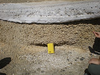
Phreatomagmatic eruptions are volcanic eruptions resulting from interaction between magma and water. They differ from exclusively magmatic eruptions and phreatic eruptions. Unlike phreatic eruptions, the products of phreatomagmatic eruptions contain juvenile (magmatic) clasts. It is common for a large explosive eruption to have magmatic and phreatomagmatic components.
Sollipulli is an ice-filled volcanic caldera and volcanic complex, which lies southeast of the small town of Melipeuco in the La Araucanía Region, Chile. It is part of the Southern Volcanic Zone of the Andes, one of the four volcanic belts in the Andes chain.

Reclus, also written as Reclús, is a cinder cone and stratovolcano located in the Southern Patagonian Ice Field, Chile. Part of the Austral Volcanic Zone of the Andes, its summit rises 1,000 metres (3,300 ft) above sea level and is capped by a crater about 1 kilometre (0.62 mi) wide. Close to the volcano lies the Amalia Glacier, which is actively eroding Reclus.

Monte Burney is a volcano in southern Chile, part of its Austral Volcanic Zone which consists of six volcanoes with activity during the Quaternary. This volcanism is linked to the subduction of the Antarctic Plate beneath the South America Plate and the Scotia Plate.
There are two large sulfate spikes caused by mystery volcanic eruptions in the mid-1400s: the 1452/1453 mystery eruption and 1458 mystery eruption. Before 2012, the date of 1458 sulfate spike was incorrectly assigned to be 1452 because previous ice core work had poor time resolution. The exact location of this eruption is uncertain, but possible candidates include the submerged caldera of Kuwae in the Coral Sea, Mount Reclus and Tofua caldera. The eruption is believed to have been VEI-7.
Mount Rittmann is a volcano in Antarctica. Discovered in 1988–1989 by an Italian expedition, it was named after the volcanologist Alfred Rittmann (1893–1980). It features a 2 kilometres (1.2 mi) or 8 by 5 kilometres wide caldera which crops out from underneath the Aviator Glacier. The volcano was active during the Pliocene and into the Holocene, including large explosive eruptions; a major eruption occurred in 1254 CE and deposited tephra over much of Antarctica. Currently, the volcano is classified as dormant.
The McMurdo Volcanic Group is a large group of Cenozoic volcanic rocks in the western Ross Sea and central Transantarctic Mountains areas of Antarctica. It is one of the largest provinces of alkaline volcanism in the world, having formed as a result of continental rifting along the West Antarctic Rift System. The McMurdo Volcanic Group is part of the Western Ross Supergroup, a stratigraphic unit that also includes the Meander Intrusive Group.

Mount Berlin is a glacier-covered volcano in Marie Byrd Land, Antarctica, 100 kilometres (62 mi) from the Amundsen Sea. It is a roughly 20-kilometre-wide (12 mi) mountain with parasitic vents that consists of two coalesced volcanoes: Berlin proper with the 2-kilometre-wide (1.2 mi) Berlin Crater and Merrem Peak with a 2.5-by-1-kilometre-wide crater, 3.5 kilometres (2.2 mi) away from Berlin. The summit of the volcano is 3,478 metres (11,411 ft) above sea level. It has a volume of 200 cubic kilometres (48 cu mi) and rises from the West Antarctic Ice Sheet. It is part of the Marie Byrd Land Volcanic Province. Trachyte is the dominant volcanic rock and occurs in the form of lava flows and pyroclastic rocks.

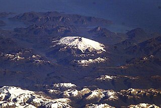
Hudson Volcano is the most active volcano in the southern part of the Southern Volcanic Zone of the Andes Mountains in Chile, having erupted most recently in 2011. It was formed by the subduction of the oceanic Nazca Plate under the continental South American Plate. South of Hudson is a smaller volcano, followed by a long gap without active volcanoes, then the Austral Volcanic Zone. Hudson has the form of a 10-kilometre-wide (6-mile) caldera filled with ice; the Huemules Glacier emerges from the northwestern side of the caldera. The volcano has erupted rocks ranging from basalt to rhyolite, but large parts of the caldera are formed by non-volcanic rocks.