The district of Aachen is a district in the west of North Rhine-Westphalia, Germany. Neighboring districts are Heinsberg, Düren, Euskirchen, and also the Netherlands province of Limburg and the Belgian province of Liège. Its administrative body is the Städtregionsparlament, headed by the Städteregionspräsident or "region president".
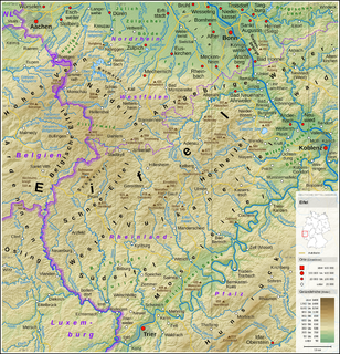
The Eifel is a low mountain range in western Germany and eastern Belgium. It occupies parts of southwestern North Rhine-Westphalia, northwestern Rhineland-Palatinate and the southern area of the German-speaking Community of Belgium.

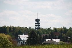
Monschau is a small resort town in the Eifel region of western Germany, located in the Aachen district of North Rhine-Westphalia.
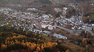
Schleiden is a town in North Rhine-Westphalia, Germany. It lies in the Eifel hills, in the district of Euskirchen, and has 12,998 inhabitants as of 30 June 2017. Schleiden is connected by a tourist railway to Kall, on the Eifel Railway between Cologne and Trier. The town consists of 18 settlements, the largest of which are Gemünd and Schleiden proper.
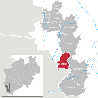
Roetgen is a municipality in the district of Aachen, in North Rhine-Westphalia, Germany.

Ordensburg Vogelsang is a former Nazi estate placed at the former military training area in Eifel National Park in North Rhine-Westphalia. The landmarked and completely preserved estate was used by the National Socialists between 1936 and 1939 as an educational centre for future leaders. Since 1 January 2006 the area has been open to visitors. It is one of the largest architectural relics of National Socialism. The gross area of the landmarked buildings is 50,000 m2.

Hallschlag is a village in the Vulkaneifel district in Rhineland-Palatinate, Germany. The municipality belongs to the Verbandsgemeinde of Obere Kyll, whose seat is in the municipality of Gerolstein.
The Rur Eifel lies in the district of Düren in the German state of North Rhine-Westphalia, and is a local recreation area from the regions of Cologne, Aachen, Düsseldorf, Krefeld, Mönchengladbach and Bonn. Its name comes from the river Rur and the Eifel Mountains.
The Eifel National Park is the 14th national park in Germany and the first in North Rhine-Westphalia. The park was founded in 2004, and is classified as a "national park in development".

The Urft is a 46.4-kilometre-long (28.8 mi) right-hand tributary of the Rur in the county of Euskirchen in the German state of North Rhine-Westphalia. It flows through the village of Urft in the municipality of Kall. The Urft rises in the North Eifel region of the Eifel Mountains.
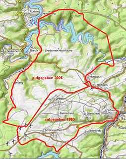
Vogelsang Military Training Area lay in the German North Eifel hills between the villages of Simmerath, Heimbach and Schleiden in the state of North Rhine-Westphalia. It was established in 1946 and handed back at the end of 2005, and consisted of the grounds of the former Nazi leadership training centre in the fort of Vogelsang on the Erpenscheid hill plus additional terrain including the so-called Dreiborn Plateau. In the north and east it was bounded by the Urft Reservoir. The training area had an area of around 45 km2 and since 1 January 2006 has been fully incorporated into the Eifel National Park. Until 1950 the training area was run by the British armed forces and thereafter until 31 December 2005 by the Belgian military.

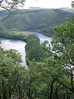
The Urft Dam is a 58.50 metre high dam in the southwestern part of the state of North Rhine-Westphalia in Germany. It was built in 1905. The dam impounds the River Urft in the district of Euskirchen to create the Urft Reservoir (Urftstausee), 2.16 km² in area. The reservoir is also called the Urftsee.

The Kermeter is an upland region, up to 527.8 m above sea level (NN), which is part of the Rureifel within the North Eifel in the districts of Aachen, Düren and Euskirchen in the southwestern part of the state of North Rhine-Westphalia in Germany.
The Michelsberg, at 586.1 m above sea level (NHN), is the highest point in the borough of Bad Münstereifel in the county of Euskirchen in the German state of North Rhine-Westphalia. The hill, which rises near the village of Mahlberg belongs to that part of the Eifel mountains known as the Ahr Hills (Ahreifel), and is the second highest point in the range.

Gemünd is a village in the Eifel region of Germany. With about 3,800 inhabitants it is the largest village in the municipality of Schleiden. It is also a well known Kneipp resort.

The Eigart is a hill located in the county of Euskirchen in the German state of North Rhine-Westphalia at 565.5 m above sea level (NN), in the North Eifel.
The Wildbretshügel, at 525.3 m above sea level (NHN), is the third highest hill in the Kermeter, an upland region which is part of the Northern Eifel. It is located near Gemünd and Hasenfeld in the counties of Euskirchen and Düren in the German state of North Rhine-Westphalia.
The Obersee near Simmerath in the borough of Aachen is the main forebay of the Rur Reservoir on the River Rur in the Eifel mountains of Germany. Its barrier is the Paulushofdamm. The reservoir, like that of the Rur Dam, belongs to the Eifel-Rur Water Company. The reservoir provides drinking water.

Schöneseiffen is a village southwest of Schleiden in the county of Euskirchen in the German state of North Rhine-Westphalia. The Dieffenbach stream rises north of the village. Schöneseiffen has a population of 433 (2021). Schöneseiffen has sports field, a Bürgerhaus and a youth centre.
The Verbrannter Berg near Wolfgarten in the county of Euskirchen in the German state of North Rhine-Westphalia is a hill, 516.2 m above sea level (NHN), in the Kermeter, a ridge in the Eifel mountains, in the region of Rur Eifel; at the same time Verbrannter Berg is the name of a parcel of land.