Schleiden

Last updated
Schleiden
Schleiden 001-.jpg
Aerial view
Flagge Schleiden.svg
DEU Schleiden COA.svg
Location of Schleiden within Euskirchen district
Schleiden in EU.svgBlankenheimKallDahlem
Germany adm location map.svg
Red pog.svg
Schleiden
North Rhine-Westphalia location map 01.svg
Red pog.svg
Schleiden
Coordinates: 50°31′59″N06°28′00″E / 50.53306°N 6.46667°E / 50.53306; 6.46667 Coordinates: 50°31′59″N06°28′00″E / 50.53306°N 6.46667°E / 50.53306; 6.46667
Country Germany
State North Rhine-Westphalia
Admin. region Köln
District Euskirchen
Government
   Mayor (201823) Ingo Pfennings [1] (CDU)
Area
  Total122.09 km2 (47.14 sq mi)
Elevation
456 m (1,496 ft)
Population
 (2021-12-31) [2]
  Total12,956
  Density110/km2 (270/sq mi)
Time zone UTC+01:00 (CET)
  Summer (DST) UTC+02:00 (CEST)
Postal codes
53937
Dialling codes 02445
Vehicle registration EU, SLE
Website www.schleiden.de

Schleiden is a town in North Rhine-Westphalia, Germany. It lies in the Eifel hills, in the district of Euskirchen, and has 12,998 inhabitants as of 30 June 2017. [3] Schleiden is connected by a tourist railway to Kall, on the Eifel Railway between Cologne and Trier. The town consists of 18 settlements, the largest of which are Gemünd and Schleiden proper.

Contents

Sub-divisions

The borough of Schleiden is divided into 18 settlements (population figures of those at their main residence as at September 2020): [4]

SettlementPopulation
Berescheid 192
Broich 375
Bronsfeld 572
Dreiborn 988
Ettelscheid 275
Gemünd 3,868
Harperscheid 426
Herhahn 463
Kerperscheid 80
Morsbach 556
Nierfeld 451
Oberhausen 838
Olef 1,120
Scheuren 371
Schleiden2,289
Schöneseiffen 424
Wintzen 85
Wolfgarten 209
Total13,582

Neighbouring municipalities

History

Historical affiliations

Civil Ensign of Luxembourg.svg County of Luxembourg 1271–1353
Civil Ensign of Luxembourg.svg Duchy of Luxembourg 1353–1795
Flag of France (1794-1815).svg French Republic 1795–1804
Flag of France (1794-1815).svg French Empire 1804–1815
Flag of the Kingdom of Prussia (1803-1892).svg  Kingdom of Prussia 1815–1871
Flag of the German Empire.svg  German Empire 1871–1918
Flag of Germany (3-2 aspect ratio).svg  Weimar Republic 1918–1933
Flag of Germany (1935-1945).svg  Nazi Germany 1933–1945
Flag of Germany (1946-1949).svg  Allied-occupied Germany 1945–1949
Flag of Germany.svg  West Germany 1949–1990
Flag of Germany.svg  Germany 1990–present

Schleiden Schleiden (Eifel) 65.jpg
Schleiden
Schleiden, roundabout feature with national park logo Schleiden, Kreisel mit Nationalparklogo.jpg
Schleiden, roundabout feature with national park logo

In the Middle Ages and Early Modern times, Schleiden was the centre of a lordship, later the County of Schleiden, which itself was part of the Duchy of Luxembourg, from 1441/43 as part of the Burgundian Netherlands (first under the Burgundians, then the Habsburgs). After the division of the Netherlands, the Duchy of Luxembourg with Schleiden remained as part of the Spanish line of the Habsburgs. After the War of Spanish Succession, the Duchy of Luxembourg, along with Schleiden, went to the Austrian line of the House of Habsburg. When revolutionary France conquered the Austrian Netherlands in 1794/95, the Duchy of Luxembourg was quickly divided into the three French departments: Forêts, Sambre-et-Meuse and Ourthe. Schleiden was in Ourthe (capital: Liege). At the Vienna Congress of 1815, the formerly Luxembourgian areas east of the Our, Sauer and Moselle rivers were given to the Kingdom of Prussia. Thus, Schleiden became "Prussian" and, in 1871, part of the German Empire after having belonged to the Duchy of Luxembourg for centuries.

The small town of Schleiden has produced two important Christian humanists: Johannes Sleidanus and Johannes Sturm, also known as Ioannes Sturmius.

In 1944 the Battle of Wahlerscheid took place nearby.

Mayors

[5]

Education

There are the following schools in the city:

Schleiden castle aerial view Schloss Schleiden 005-.jpg
Schleiden castle aerial view

Sights

Schleiden Castle with its church, aerial view (2015) Schloss Schleiden 005-.jpg
Schleiden Castle with its church, aerial view (2015)
Urft Reservoir, aerial view (2009) Urfttalsperre1.JPG
Urft Reservoir, aerial view (2009)

Olef Valley Railway

MAN railbus of the Oleftalbahn at Hp. Blumenthal Oleftalbahn Schienenbus Blumenthal.JPG
MAN railbus of the Oleftalbahn at Hp. Blumenthal

The Olef Valley Railway (from Kall to Hellenthal) stopped at Schleiden station; regular passenger services were discontinued by Deutsche Bundesbahn in 1981. Because of the Eifel National Park, which was newly established in 2004, the state of North Rhine-Westphalia is supporting tourism with a two-year programme of passenger services in the tourist season on Sundays and public holidays. These services terminated in 2004 in the district of Gemünd, and in 2005 they continued to Schleiden. The regional railway was managed by the Verkehrsverbund Rhein-Sieg; Rurtalbahn was the operator. Regular traffic ended on 16 October 2005. Since 2006 services have been operated privately as a museum railway in the summer season, with the 2008 season being operated by the Rhein-Sieg-Eisenbahn. From 2010, the trains will run again to Hellenthal station, using an historic MAN railbus. Due to massive damage caused by the 2021 European floods, museum railway services were suspended. [6]

Until 1997 there was regular freight traffic via Schleiden to Hellenthal, after that only military traffic to Schleiden-Höddelbusch (tank loading ramp). The last troop loading took place there in winter 2002 with diesel and steam locomotives from a private railway. [7] Belgium handed back the Vogelsang Training Area on 1 January 2006. The training area on the Dreiborn Plateau was turned over to non-military use and has a documentation centre and hiking area.

Public figures

Johannes Sleidanus Sleidanus.png
Johannes Sleidanus

Related Research Articles

<span class="mw-page-title-main">Abensberg</span> Town in Bavaria, Germany

Abensberg is a town in the Lower Bavarian district of Kelheim, in Bavaria, Germany, lying around 30 km (19 mi) southwest of Regensburg, 40 km (25 mi) east of Ingolstadt, 50 km (31 mi) northwest of Landshut and 100 km (62 mi) north of Munich. It is situated on the river Abens, a tributary of the Danube.

<span class="mw-page-title-main">Luxembourg</span> Country in Western Europe

Luxembourg, officially the Grand Duchy of Luxembourg, is a small landlocked country in Western Europe. It borders Belgium to the west and north, Germany to the east, and France to the south. Its capital and most populous city, Luxembourg, is one of the four institutional seats of the European Union and the seat of several EU institutions, notably the Court of Justice of the European Union, the highest judicial authority. Luxembourg's culture, people, and languages are highly intertwined with its French and German neighbors; while Luxembourgish is the only national language of the Luxembourgish people, French is the only language for legislation, and all three – Luxembourgish, French and German – are considered official languages and are used for administrative matters in the country.

<span class="mw-page-title-main">Krefeld</span> City in North Rhine-Westphalia, Germany

Krefeld, also spelled Crefeld until 1925, is a city in North Rhine-Westphalia, Germany. It is located northwest of Düsseldorf, its center lying just a few kilometers to the west of the river Rhine; the borough of Uerdingen is situated directly on the Rhine. Because of its economic past, Krefeld is often referred to as the "Velvet and Silk City". It is accessed by the autobahns A57 (Cologne–Nijmegen) and A44 (Aachen–Düsseldorf–Dortmund–Kassel).

The district of Aachen is a district in the west of North Rhine-Westphalia, Germany. Neighboring districts are Heinsberg, Düren, Euskirchen, and also the Netherlands province of Limburg and the Belgian province of Liège. Its administrative body is the Städteregionsparlament, headed by the Städteregionspräsident or "region president".

<span class="mw-page-title-main">Eifel</span> Low mountain range in Germany

The Eifel is a low mountain range in western Germany, eastern Belgium and northern Luxembourg. It occupies parts of southwestern North Rhine-Westphalia, northwestern Rhineland-Palatinate and the southern area of the German-speaking Community of Belgium.

<span class="mw-page-title-main">Warburg</span> Town in North Rhine-Westphalia, Germany

Warburg is a town in eastern North Rhine-Westphalia, central Germany on the river Diemel near the three-state point shared by Hessen, Lower Saxony and North Rhine-Westphalia. It is in Höxter district and Detmold region. Warburg is the midpoint in the Warburger Börde. Since March 2012 the city is allowed to call itself 'Hanseatic City of Warburg'.

<span class="mw-page-title-main">Monschau</span> Resort town in North Rhine-Westphalia, Germany

Monschau is a small resort town in the Eifel region of western Germany, located in the Aachen district of North Rhine-Westphalia.

<span class="mw-page-title-main">Mülheim</span> City in North Rhine-Westphalia, Germany

Mülheim, officially Mülheim an der Ruhr and also described as "City on the River", is a city in North Rhine-Westphalia in Germany. It is located in the Ruhr Area between Duisburg, Essen, Oberhausen and Ratingen. It is home to many companies, and two Max Planck Institutes.

Geheimrat was the title of the highest advising officials at the Imperial, royal or princely courts of the Holy Roman Empire, who jointly formed the Geheimer Rat reporting to the ruler. The term remained in use during subsequent monarchic reigns in German-speaking areas of Europe until the end of the First World War. At its origin the literal meaning of the word in German was 'trusted advisor' - the word "geheim" (secret) implying that such an advisor could be trusted with the Monarch's secrets. The English-language equivalent is Privy Councillor.

<span class="mw-page-title-main">Bitburg</span> Town in Rhineland-Palatinate, Germany

Bitburg is a city in Germany, in the state of Rhineland-Palatinate approximately 25 km (16 mi.) northwest of Trier and 50 km (31 mi.) northeast of Luxembourg city. The American Spangdahlem Air Base is nearby.

<span class="mw-page-title-main">Bad Münstereifel</span> Place in North Rhine-Westphalia, Germany

Bad Münstereifel is a historical spa town in the district of Euskirchen, Germany, with about 17,000 inhabitants, situated in the far southwest of the German state of North Rhine-Westphalia. The little town is one of only a few historical towns in the southwest of North Rhine-Westphalia, and because of this is often overcrowded by tourists throughout spring and summer.

<span class="mw-page-title-main">Alsdorf</span> Town in North Rhine-Westphalia, Germany

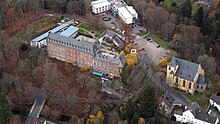
Alsdorf is a municipality in the district of Aachen, in North Rhine-Westphalia, Germany. Until the 21st century Alsdorf was a mining area, but now many service companies have established themselves in Alsdorf. Alsdorf has an indoor arena, a cinema, a mining museum and a zoo. One of Alsdorf's famous sights is the old Castle.

<span class="mw-page-title-main">Gerolstein</span> Town in Rhineland-Palatinate, Germany

Gerolstein is a town in the Vulkaneifel district of Rhineland-Palatinate, Germany. Gerolstein is a local municipality of the Verbandsgemeinde Gerolstein. It has been approved as a Luftkurort.

<span class="mw-page-title-main">Attendorn</span> Town in North Rhine-Westphalia, Germany

Attendorn is a German town in the Olpe district in North Rhine-Westphalia. As of 2019 it had a population of 24,264.

<span class="mw-page-title-main">Finnentrop</span> Town in North Rhine-Westphalia, Germany

Finnentrop is a Gemeinde (municipality) in Olpe district in North Rhine-Westphalia, Germany.

<span class="mw-page-title-main">Oberbettingen</span> Municipality in Rhineland-Palatinate, Germany

Oberbettingen is an Ortsgemeinde – a municipality belonging to a Verbandsgemeinde, a kind of collective municipality – in the Vulkaneifel district in Rhineland-Palatinate, Germany. It belongs to the Verbandsgemeinde of Gerolstein, whose seat is in the like-named town.

<span class="mw-page-title-main">Eifel National Park</span> National Park in North Rhine-Westphalia, Germany

The Eifel National Park is the 14th national park in Germany and the first in North Rhine-Westphalia. The park was founded in 2004, and is classified as a "national park in development".

<span class="mw-page-title-main">Urft Dam</span> Dam in Kreis Euskirchen

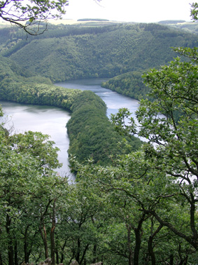
The Urft Dam is a 58.50 metre high dam in the southwestern part of the state of North Rhine-Westphalia in Germany. It was built in 1905. The dam impounds the River Urft in the district of Euskirchen to create the Urft Reservoir (Urftstausee), 2.16 km² in area. The reservoir is also called the Urftsee.

<span class="mw-page-title-main">Trier West Railway</span> Railway in Europe

The Trier West Railway a 14 km-long railway line running from Trier-Ehrang in the German state of Rhineland-Palatinate to Wasserbillig in Luxembourg via Trier-West. The double-track, electrified section between Trier-Ehrang and the Moselle bridge at Konz forms a bypass of the Trier rail node.

Dollendorf is a village in the municipality of Blankenheim in the district of Euskirchen in the German state of North Rhine-Westphalia. It gives its name to the surrounding limestone depression (Kalkmulde).

References

  1. Bürgermeisterstichwahl Stadt Schleiden, accessed 20 June 2021.
  2. "Bevölkerung der Gemeinden Nordrhein-Westfalens am 31. Dezember 2021" (in German). Landesbetrieb Information und Technik NRW . Retrieved 20 June 2022.
  3. "Einwohnerzahlen im Regierungsbezirk Köln". Information und Technik Nordrhein-Westfalen: Statistik. it.nrw.de (accessed 24 June 2018).
  4. Stadt Schleiden:Bevölkerungsstatistik (pdf; 20 kB)
  5. http://www.schleiden.de/sv_schleiden/Rathaus/Rathaus%20&%20Politik/Rathaus/Verwaltungsorganisation/Verwaltungsf%C3%BChrung%20seit%201972 administration since 1972 homepage of the town Schleiden
  6. Wolfgang Kirfel (2021-08-28). "Zukunft der Oleftalbahn ungewiss: 90 Prozent der Strecke wurden von der Flut zerstört" . Retrieved 2021-09-08.
  7. Militärzug am 28. Januar 2002 in Schleiden