Postal codes in Germany

Last updated

Germany introduced postal codes on 25 July 1941, in the form of a two-digit system that was applied initially for the parcel service and later for all mail deliveries. This system was replaced in 1962 in West Germany by a four-digit system; three years later East Germany followed with its own four-digit system. Whereas the Federal Republic introduced a system with space left for the East German postal system after a possible reunification, such as by omitting all codes starting with '1' (except 1000 for West Berlin) and '9', the German Democratic Republic had a system that used all codes starting from '1' to '9' just for East Germany.

Contents

Today, German postal codes are numeric and have consisted of five digits since 1993. Between 1990 and 1993 the previous four-digit codes in the former West were prefixed with the letter "W", and in the former East with the letter "O" (for "Ost", "east" in German). Even though the western system had kept some number ranges free, specifically for later integration of the East in case of reunification, it was decided that the time was right to create an entirely new system for the 1990s, in which larger towns and cities would be divided into multiple postal code areas (the old system had inconsistently used additional numbers after the city's names), and companies receiving large amounts of post (such as mail-order businesses) could be assigned their own private code. This resulted in a system where one could no longer identify the size of the city by the number of trailing zeros in its postal code (such as 2000 for Hamburg or 8000 for Munich).

Post office boxes are arranged in racks containing several dozens of them. Each rack is identified by an individual postal code.

The 1993 system has geographic zones on the first (Postleitzonen) and on the second level (Postleitregion), e.g., 1 is North East Germany, and 10 is a zone in the inner city of Berlin.

German Postleitzahl map of the first two digits. The green lines mark state borders, which do not always correspond with postal code areas. German postcode information.png
German Postleitzahl map of the first two digits. The green lines mark state borders, which do not always correspond with postal code areas.
P. O. box racks in a German post office of the Duisburg post code area. The top number is the postal code (PLZ=Postleitzahl) for the individual rack. Postfachschraenke.jpg
P. O. box racks in a German post office of the Duisburg post code area. The top number is the postal code (PLZ=Postleitzahl) for the individual rack.

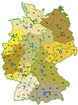
On 31 December 2007, the zones had the following area and population:

LeitzoneArea (km²)PopulationRegion coveredLarge cities
037,187.86,819,607 Saxony, southern parts of Saxony-Anhalt and Brandenburg, eastern part of Thuringia Dresden, Leipzig, Halle, Chemnitz, Cottbus, Jena
147,642.47,034,541 Berlin, larger parts of Brandenburg and Mecklenburg-Vorpommern, small parts of Lower Saxony and Saxony-AnhaltBerlin, Potsdam, Frankfurt (Oder), Rostock, Schwerin
244,207.48,691,409 Hamburg, Schleswig-Holstein, northern part of Lower Saxony, Bremen, small part of Mecklenburg-VorpommernHamburg, Lübeck, Kiel, Bremen, Bremerhaven, Oldenburg
345,488.19,012,212southern part of Lower Saxony, eastern part of Westphalia, northern parts of Hesse, Thuringia and Saxony-Anhalt Hanover, Bielefeld, Kassel, Fulda, Gießen, Göttingen, Brunswick, Magdeburg
420,212.310,331,535north-western part of North Rhine-Westphalia, south-western part of Lower Saxony Düsseldorf, Dortmund, Essen, Duisburg, Bochum, Wuppertal, Bielefeld, Münster, Mönchengladbach, Gelsenkirchen, Oberhausen, Osnabrück
528,834.59,233,815south-western part of North Rhine-Westphalia, larger part of Rhineland-Palatinate, small part of Hesse Cologne, Bonn, Aachen, Mainz, Koblenz, Trier
617,247.97,540,503southern parts of Hesse, Rhineland-Palatinate, Saarland, small parts of Bavaria and Baden-Württemberg Frankfurt (Main), Wiesbaden, Darmstadt, Saarbrücken, Heidelberg, Mannheim, Aschaffenburg
727,864.28,715,898larger part of Baden-Württemberg, small part of Rhineland-Palatinate Stuttgart, Tübingen, Freiburg, Konstanz, Baden-Baden
836,427.27,675,001southern part of Bavaria, south-eastern part of Baden-Württemberg Munich, Rosenheim, Augsburg, Ulm, Ingolstadt
947,803.77,163,416northern part of Bavaria (Franconia), larger part of Thuringia, small part of Baden-Württemberg Nuremberg, Würzburg, Erfurt, Weimar, Eisenach, Bamberg, Bayreuth

There are three states (Saxony, Saarland and Schleswig-Holstein), in addition to the city states (Berlin, Bremen and Hamburg), that lie completely within one postal zone, while three states (Lower Saxony, Saxony-Anhalt and Baden-Württemberg) cover four postal zones.

History of postal code systems in Germany

Precursors

With the help of ring number stamps, the administration of the Thurn-und-Taxis-Post made it possible for the first time in 1853 to recognize places from a region by a range of numbers. From number 338, assigned on 1 October 1854 to the post office in Lehesten, the numbers are randomly assigned.

In 1917, Carl Bobe divided Germany into metropolitan areas, regional areas and local areas in an organizational scheme.

See also

Related Research Articles

<span class="mw-page-title-main">Postal code</span> Series of letters and digits for sorting mail

A postal code is a series of letters or digits or both, sometimes including spaces or punctuation, included in a postal address for the purpose of sorting mail.

<span class="mw-page-title-main">ZIP Code</span> Numeric postal code used in the United States and its territories

A ZIP Code is a system of postal codes used by the United States Postal Service (USPS). Introduced on July 1, 1963, the basic format consisted of five digits. In 1983, an extended ZIP+4 code was introduced; it included the five digits of the ZIP Code, followed by a hyphen and four digits that designated a more specific location.

<span class="mw-page-title-main">Postcodes in the United Kingdom</span>

Postal codes used in the United Kingdom, British Overseas Territories and Crown dependencies are known as postcodes. They are alphanumeric and were adopted nationally between 11 October 1959 and 1974, having been devised by the General Post Office. A full postcode is known as a "postcode unit" and designates an area with several addresses or a single major delivery point.

<span class="mw-page-title-main">States of Germany</span> First-level administrative subdivisions of the Federal Republic of Germany

The Federal Republic of Germany, as a federal state, consists of sixteen states. Berlin, Hamburg and Bremen are called Stadtstaaten ("city-states"), while the other thirteen states are called Flächenländer and include Bavaria, Saxony, and Thuringia which describe themselves as Freistaaten.

<span class="mw-page-title-main">Postal codes in Canada</span>

A Canadian postal code is a six-character string that forms part of a postal address in Canada. Like British, Irish and Dutch postcodes, Canada's postal codes are alphanumeric. They are in the format A1A 1A1, where A is a letter and 1 is a digit, with a space separating the third and fourth characters. As of October 2019, there were 876,445 postal codes using Forward Sortation Areas from A0A in Newfoundland to Y1A in Yukon.

A Postal Index Number refers to a six-digit code in the Indian postal code system used by India Post. On 15 August 2022, the PIN system celebrated its 50th anniversary.

On 26 June 1964, Swiss Post introduced postal codes as the third country after Germany (1941) and the United States (1963).

Postal codes were introduced in South Africa on 8 October 1973, with the introduction of automated sorting.

An address is a collection of information, presented in a mostly fixed format, used to give the location of a building, apartment, or other structure or a plot of land, generally using political boundaries and street names as references, along with other identifiers such as house or apartment numbers and organization name. Some addresses also contain special codes, such as a postal code, to make identification easier and aid in the routing of mail.

Vehicle registration plates are mandatory alphanumeric plates used to display the registration mark of a vehicle registered in Germany. They have existed in the country since 1906, with the current system in use since 1956. German registration plates are alphanumeric plates in a standardized format, issued officially by the district authorities.

The Official Municipality Key, formerly also known as the Official Municipality Characteristic Number or Municipality Code Number, is a number sequence for the identification of politically independent municipalities or unincorporated areas. Other classifications for the identification of areas include postal codes, NUTS codes or FIPS codes.

Reichspost was the name of the postal service of Germany from 1866 to 1945.

<span class="mw-page-title-main">Postal addresses in the Republic of Ireland</span> Postal code system of Ireland

A postal address in Ireland is a place of delivery defined by Irish Standard (IS) EN 14142-1:2011 and serviced by the universal service provider, An Post. Its addressing guides comply with the guidelines of the Universal Postal Union (UPU), the United Nations-affiliated body responsible for promoting standards in the postal industry, across the world.

Postal codes in Argentina are called códigos postales. Until 1998 Argentina employed a four-digit postal code for each municipality, with the first digit representing a region in the country, except in the case of the city of Buenos Aires. The unique codes became the base for the newer system, officially called CPA.

<span class="mw-page-title-main">Telephone numbers in Germany</span>

The regulation of telephone numbers in Germany is the responsibility of the Federal Network Agency of the German government. The agency has a mandate to telecommunications in Germany and other infrastructure systems.

<span class="mw-page-title-main">Postcodes in Australia</span> Numeric codes in Australia

Postcodes in Australia are used to more efficiently sort and route mail within the Australian postal system. Postcodes in Australia have four digits and are placed at the end of the Australian address, before the country. Postcodes were introduced in Australia in 1967 by the Postmaster-General's Department and are now managed by Australia Post, Australia's national postal service. Postcodes are published in booklets available from post offices or online from the Australia Post website.

<span class="mw-page-title-main">Postage stamps and postal history of Germany</span> Aspect of history

This is a survey of the postage stamps and postal history of Germany and philatelically related areas. The main modern providers of service were the Reichspost (1871–1945), the Deutsche Post under Allied control (1945–1949), the Deutsche Post of the GDR (1949–1990), the Deutsche Bundespost (1949–1995), along with the Deutsche Bundespost Berlin (1949–1990), and are now the Deutsche Post AG.

<span class="mw-page-title-main">Deutsche Post of the GDR</span>

The Deutsche Post (DP), also Deutsche Post of the GDR was the state-owned postal and telecommunications monopoly of the German Democratic Republic. The DP was placed under the control of the Ministry for Postal and Telecommunication Services of the GDR(Ministerium für Post- und Fernmeldewesen der DDR - ) - a member of the Council of Ministers of the GDR(Ministerrat der DDR) - and was in operation from 1949 until the reunification of Germany on 3 October 1990.

<span class="mw-page-title-main">Postal codes in Thailand</span> Overview of postal codes in Thailand

Postal codes in Thailand are five digit numbers. The first two digits of the postal code denote the province or special administrative area, while the last 3 digits represent the post office within the province. There are exceptions, for example, Bangkok and Samut Prakan province shared the first two digits 10xxx. It's typical to use postal code ended with zero 0 because they are assigned to post office that are responsible for delivering mail to the district. For example, mails to Dusit district destinations uses postal code 10300 except within Chitralada Palace where postal code 10303 is used. 10300 is postal code of Dusit Post Office which handles the delivery throughout Dusit district while 10303 is postal code of Chitralada Palace Post Office which does not deliver mails outside the palace. Other post offices in Dusit district exist, such as Bang Krabu Post Office with postal code 10301, the code used for mails to be delivered to P.O. Box in the post office.

<span class="mw-page-title-main">Rohrpost in Berlin</span>

The Rohrpostin Berlin, was a pneumatic tube postal service, which existed from 18 November 1865 until 1963 in West Berlin and in East Berlin until 1976.