Postal codes in Sweden

Last updated

For the purposes of directing mail, Sweden is divided into a number of postcode areas. The Swedish postcode (Swedish : postnummer) system is administered by the Swedish Mail Service (Swedish : Posten AB) on behalf of the Swedish Post and Telecom Authority (Swedish : Post- och telestyrelsen). [1]

Contents

History

Until 1968, mail in Sweden was sorted only according to geographic location, which meant that postal workers had to learn all mail centers in Sweden, and what particular mail trains served those places. In 1967, it was decided that postcodes would be introduced in Sweden as of May 12, 1968. Since then, the postcode system has been essentially the same, but a slight reform was carried out during the mid-1990s as all remaining mail terminals were equipped with automatic mail sorting machines. In 2008, Sweden was divided into more than 16,100 postcode areas. [2]

Format

The Swedish postcode system is based on a five-digit number combination, divided into two groups of three and two digits. The principle of numbering is that the lower the postcode, the further south the place is located. Excluded from the principle are postcodes beginning with number 1, which represent the capital city, Stockholm. Mail delivery centers are divided into two-, three-, and five-digit positioning groups depending on the size of the geographical place. The two-position group has larger varieties, whereas the smallest belongs to the five-digit positioning group.

According to the system, a space shall be inserted between the third and fourth digit. Earlier recommendations said that a double space should be placed between the postcode and the geographic location and that the geographic location should be written in capital letters. A single space is now the norm and capital letters are not required any more.

A typical address would look like this:

Sven Nilsson (First, and last name)
Roslagsgatan 10 (Street, and number)
113 51 Stockholm (Postcode, and geographic location)

Two-digit positioning

The two initial digits indicate city. Stockholm, Gothenburg, and Malmö are designated the two-digit series, one for mailbox- and business addresses, and the second series for street addresses.

The post codes are sorted by geographical location. Numbers starting with 10-19 are part of Stockholm; otherwise, the lower numbers are part of the bigger city areas in the south, and increase northwards.
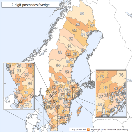
First digitRegionCities with their own second digit
1 Stockholm County with the exception of Norrtälje Municipality Stockholm (10–11 and some smaller isolated ranges)
2 Skåne County and parts of Kronoberg County and Blekinge County Malmö (20–21), Lund (22), Helsingborg (25)
3Parts of Jönköping County, Kronoberg County, Kalmar County, Blekinge County and Halland County Halmstad (30), Växjö (35), Kalmar (39)
4Parts of Västra Götaland County and Halland County Gothenburg (40–41)
5Parts of Östergötland County, Jönköping County, Kalmar County and Västra Götaland County Borås (50), Jönköping (55), Linköping (58)
6 Södermanland County, Gotland County, Värmland County and parts of Östergötland County, Västra Götaland County and Örebro County Norrköping (60), Eskilstuna (63), Karlstad (65)
7Southern and middle Uppsala County, Västmanland County, Dalarna County and parts of Stockholm County and Örebro County Örebro (70), Västerås (72), Uppsala (75)
8Northern Uppsala County, Gävleborg County, Västernorrland County and Jämtland County Gävle (80), Sundsvall (85)
9 Västerbotten County and Norrbotten County Umeå (90), Luleå (97)
2-digit postcode areas Sweden(defined through the first two postcode digits) 2 digit postcode sweden.png
2-digit postcode areas Sweden(defined through the first two postcode digits)
PostcodeGeographic locationNotes
10x xx Stockholm Mailbox and business addresses
11x xx Stockholm Street addresses
20x xx Malmö Mailbox- and business addresses
21x xx Malmö Street addresses
22x xx Lund  
25x xx Helsingborg  
30x xx Halmstad  
35x xx Växjö  
39x xx Kalmar  
40x xx Gothenburg Mailbox- and business addresses
41x xx Gothenburg Street addresses
50x xx Borås  
55x xx Jönköping  
58x xx Linköping  
60x xx Norrköping  
63x xx Eskilstuna  
65x xx Karlstad  
70x xx Örebro  
72x xx Västerås  
75x xx Uppsala  
80x xx Gävle  
85x xx Sundsvall  
90x xx Umeå  
97x xx Luleå Changed from 951 xx

The third digit in the two-digit positioning indicate type of delivery, in most cases.

PostcodeType of deliveryNote
xx0 xxMail boxes and mail addresses 
xx1 xxMail boxes and business addresses 
xx2 xxRegular mail delivery 
xx3 xxRegular mail delivery 
xx4 xxRegular mail delivery 
xx5 xxCountryside mail delivery 
xx6 xxRegular mail delivery 
xx7 xxRegular mail delivery 
xx8 xxRegular reply mail 
xx9 xxTemporaryTemporary postcodes

The fourth and fifth digit indicate the geographic area. Postcodes with the same first four digits may represent a part of a city or equivalent.

Three-digit positioning

The first two digits indicate the geographical area in. Previously, these figures indicated the mail terminal that sorted mail for the particular geographic location.

Postal codeApproximate geographical area
10x xx - 11x xx Norrmalm, Östermalm, Västermalm, Södermalm
12x xx Skarpnäck, Farsta, Enskede-Årsta-Vantör, Älvsjö, Hägersten-Liljeholmen, Skärholmen
13x xx Nacka, Värmdö, Tyresö, Haninge
14x xx Huddinge, Botkyrka, Salem, Nynäshamn
15x xx Södertälje, Nykvarn
16x xx Bromma, Hässelby-Vällingby, Spånga, Kista
17x xx Ekerö, Järfälla, Sundbyberg, Solna
18x xx Lidingö, Danderyd, Täby, Vallentuna, Österåker, Waxholm
19x xx Sollentuna, Upplands-Väsby, Sigtuna, Upplands-Bro
23x xxSouth-western Skåne County
24x xxCentral Skåne County
26x xxNorth-western Skåne County
27x xxSouth-eastern Skåne County
28x xxNorthern Skåne County and south-western Kronoberg County
29x xxNorth-eastern Skåne County and western Blekinge County
31x xxSouthern Halland County
33x xxWestern Jönköping County
34x xxWestern Kronoberg County
36x xxEastern Kronoberg County
37x xxMiddle and eastern Blekinge County
38x xxSouthern Kalmar County
42x xx - 47x xxNorthern Halland County and western Västra Götaland County
51x xxSouthern Västra Götaland County
52x xx - 54x xxEastern Västra Götaland County
56x xx - 57x xxNorthern Jönköping County and middle Kalmar County
59x xxSouthern Östergötland County and northern Kalmar County
61x xxNorthern Östergötland County and southern Södermanland County
62x xx Gotland County
64x xxNorthern Södermanland County
66x xx - 68x xx Värmland County and northern Västra Götaland County
69x xxSouthern Örebro County
71x xxNorthern Örebro County
73x xx Västmanland County
74x xxMiddle and southern Uppsala County
76x xx Norrtälje Municipality
77x xxSouthern Dalarna County
78x xxCentral and western Dalarna County
79x xxNorthern Dalarna County
81x xxSouthern Gävleborg County and northern Uppsala County
82x xxNorthern Gävleborg County
83x xxNorthern Jämtland County
84x xxSouthern Jämtland County and south-western Västernorrland County
86x xxSouth-eastern Västernorrland County
87x xxMiddle Västernorrland County
88x xxNorth-western Västernorrland County
89x xxNorth-eastern Västernorrland County
91x xxSouthern Västerbotten County
92x xxMiddle Västerbotten County
93x xxNorth-eastern Västerbotten County and South-western Norrbotten County
94x xxSouthern Norrbotten County
95x xxMiddle Norrbotten County
96x xxSouth-eastern Norrbotten County
98x xxNorthern Norrbotten County

The third figure in combination with the first two indicates the mail delivery location. The fourth figure is the type of delivery.

PostcodeType of delivery
xxx 0xMailboxes- and postal addresses
xxx 1xMailboxes, business addresses
xxx 2xRegular mail delivery, mailboxes, and reply mail
xxx 3xRegular mail delivery
xxx 4xRegular mail delivery
xxx 5xRegular mail delivery
xxx 6xRegular mail delivery
xxx 7xRegular mail delivery
xxx 8xReply mail, and business addresses
xxx 9xCountryside mail delivery

Five-digit positioning

Five-digit positioning is used for locations small enough that only one or a few postal codes are required for routing. Since the reform of the postcode system in the mid-1990s, only a few five-digit positions locations remain. These locations are often so small and remote that it is not practically possible to transfer all mail to a larger three-digit locations. Five-digit position locations are usually in the archipelago and in the mountains.

Related Research Articles

<span class="mw-page-title-main">Postal code</span> Series of letters and digits for sorting mail

A postal code is a series of letters or digits or both, sometimes including spaces or punctuation, included in a postal address for the purpose of sorting mail.

<span class="mw-page-title-main">ZIP Code</span> Numeric postal code used in the United States and its territories

A ZIP Code is a postal code used by the United States Postal Service (USPS). Introduced on July 1, 1963, the basic format consisted of five digits. In 1983, an extended ZIP+4 code was introduced; it included the five digits of the ZIP Code, followed by a hyphen and four digits that designated a more specific location.

<span class="mw-page-title-main">Postcodes in the United Kingdom</span>

Postal codes used in the United Kingdom, British Overseas Territories and Crown dependencies are known as postcodes. They are alphanumeric and were adopted nationally between 11 October 1959 and 1974, having been devised by the General Post Office. A full postcode is known as a "postcode unit" and designates an area with several addresses or a single major delivery point.

<span class="mw-page-title-main">Postal codes in Canada</span> Overview of postal codes in Canada

A Canadian postal code is a six-character string that forms part of a postal address in Canada. Like British, Irish and Dutch postcodes, Canada's postal codes are alphanumeric. They are in the format A1A 1A1, where A is a letter and 1 is a digit, with a space separating the third and fourth characters. As of October 2019, there were 876,445 postal codes using Forward Sortation Areas from A0A in Newfoundland to Y1A in Yukon.

A Postal Index Number refers to a six-digit code in the Indian postal code system used by India Post. On 15 August 2022, the PIN system celebrated its 50th anniversary.

Mailsort was a five-digit address-coding scheme used by the Royal Mail and its business customers for the automatic direction of mail until 2012. Mail users who could present mail sorted by Mailsort code and in quantities of 4,000 upwards receive a discounted postal rate.

Postcodes in New Zealand consist of four digits, the first two of which specify the area, the third the type of delivery, and the last the specific lobby, RD number, or suburb. The present postcode system was introduced in New Zealand in June 2006, which, unlike the previous system, applies to all items of mail with effect from June 2008. In October 2008, New Zealand Post launched a 'remember your postcode' campaign, offering a NZ$10,000 prize for remembering a postcode.

Postal codes were introduced in South Africa on 8 October 1973, with the introduction of automated sorting.

Postal codes were introduced in France in 1964, when La Poste introduced automated sorting. They were updated to use the current 5 digit system in 1972.

An address is a collection of information, presented in a mostly fixed format, used to give the location of a building, apartment, or other structure or a plot of land, generally using political boundaries and street names as references, along with other identifiers such as house or apartment numbers and organization name. Some addresses also contain special codes, such as a postal code, to make identification easier and aid in the routing of mail.

A post town is a required part of all postal addresses in the United Kingdom and Ireland, and a basic unit of the postal delivery system. Including the correct post town in the address increases the chance of a letter or parcel being delivered on time. Post towns in general originated as the location of delivery offices. As of 2004, their main function is to distinguish between localities or street names in addresses not including a postcode.

<span class="mw-page-title-main">Postal codes in China</span>

Postal codes in the People's Republic of China are postal codes used by China Post for the delivery of letters and goods within mainland China.

<span class="mw-page-title-main">Postal addresses in the Republic of Ireland</span> Postal code system of Ireland

A "postal address" in Ireland is a place of delivery defined by Irish Standard (IS) EN 14142-1:2011 and serviced by the universal service provider, An Post. Its addressing guides comply with the guidelines of the Universal Postal Union (UPU), the United Nations-affiliated body responsible for promoting standards in the postal industry, across the world.

<span class="mw-page-title-main">Postcodes in Australia</span> Numeric codes in Australia

Postcodes in Australia are used to more efficiently sort and route mail within the Australian postal system. Postcodes in Australia have four digits and are placed at the end of the Australian address, before the country. Postcodes were introduced in Australia in 1967 by the Postmaster-General's Department and are now managed by Australia Post, Australia's national postal service. Postcodes are published in booklets available from post offices or online from the Australia Post website.

<span class="mw-page-title-main">Postal codes in Thailand</span> Overview of postal codes in Thailand

Postal codes in Thailand are five digit numbers. The first two digits of the postal code denote the province or special administrative area, while the last 3 digits represent the post office within the province. There are exceptions, for example, Bangkok and Samut Prakan province shared the first two digits 10xxx. It's typical to use postal code ended with zero 0 because they are assigned to post office that are responsible for delivering mail to the district. For example, mails to Dusit district destinations uses postal code 10300 except within Chitralada Palace where postal code 10303 is used. 10300 is postal code of Dusit Post Office which handles the delivery throughout Dusit district while 10303 is postal code of Chitralada Palace Post Office which does not deliver mails outside the palace. Other post offices in Dusit district exist, such as Bang Krabu Post Office with postal code 10301, the code used for mails to be delivered to P.O. Box in the post office.


Postal codes in South Korea are 5-digit numeric. A new system of post codes was introduced on August 1, 2015. The postal code of the Republic of Korea was first enacted on July 1, 1970, and was revised three times in 1988, 2000, and 2015.

In 2012, the government of Trinidad and Tobago approved the introduction of postal codes starting later that same year. In addition to the postal code implementation the country has embarked on a nationwide address improvement initiative adopting the Universal Postal Union (UPU) S-42 international standard of addressing. The UPU is an arm of the United Nations and is the coordinating body of postal services worldwide. The intent of this exercise is to correct poor addressing in Trinidad & Tobago and assign to each address a six-digit postal code. This change will result in the following:

Postal codes were adopted in Ghana on 18 October 2017, following the launch of the National Digital Address System. As a joint venture between Ghana Post and Vokacom Ltd as GhanaPost GPS, the Digital Address System assigned postal codes and unique addresses to every square in Ghana.

Postal codes used in Saudi Arabia are colloquially known as postcodes.

References

  1. Vad används postnumren till?, Post- och telestyrelsen. (Swedish)
  2. Postnummer, Post- och telestyrelsen. (Swedish)