Rosenheim is a city in Bavaria, Germany. It is an independent city located in the centre of the district of Rosenheim (Upper Bavaria), and is also the seat of its administration. It is located on the west bank of the Inn at the confluence of the rivers Inn and Mangfall, in the Bavarian Alpine Foreland. It is the third largest city in Upper Bavaria with over 64,000 inhabitants. Rosenheim is the economic centre and the busiest place in the region.
The population of the actual city is approximately 60,000 inhabitants with up to 125,000 in the surrounding area. Rosenheim is situated in the Upper-Bavarian Alpine Foothills, 450 metres (1,476 feet)above sea level and covers an area of 37.52 square kilometres (14.49sqmi). The capital of Bavaria, Munich, is 52 kilometres (32 miles) North-West of Rosenheim. Rosenheim station is at the junction of the Munich–Rosenheim, the Rosenheim–Salzburg and the Munich–Innsbruck lines.
The landscape around Rosenheim was formed during the last ice age from the advancement of the Inn Valley Glacier and later the Rosenheim lake. The lake existed about 10,000 years ago, covering the whole Inn valley as far as Wasserburg am Inn, about 25km (16mi) north of Rosenheim.
Even today in many places around the city the former shoreline can be recognised where the former flat lake bed changes suddenly into relatively steep embankment.
View of Rosenheim in 1701
History
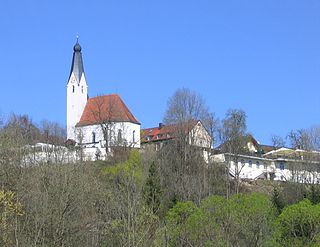
Rosenheim, churches St. Nikolaus and Heilig Geist
Rosenheim's development can be traced from its location on intersecting major trade routes. Even in early times, the town's intersecting traffic stimulated its development as a market town. It subsequently evolved from a market to a salt trade and then railway town to today's wood and college city.
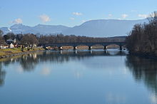
Pons Aeni
Crucial to the establishment of Rosenheim were the Inn and the corresponding Inn valley. The Romans arrived in the year 15 BC under the leadership of Drusus and Tiberius. They founded the province Noricum to the East of the Inn and Rhaetia to the west of the Inn. The colonizers built a road through the Brenner to Castra Regina, and an east–west road from Iuvavum to Augusta Vindelicum. The intersection of these two enormously important trade routes were protected by a military station whose name was "Pons Aeni". Less frequently used terms were "Ponte Aoni", "Ad enum" or "stations Enensis". The Romano Celtic settlement existed for some 500 years with that name. Pons was between Aeni Isinisca (Aying) and Bedaium[de] (today part of Seeon-Seebruck), as shown on the Roman road map Tabula Peutingeriana from the 4th century. The name "Pons Aeni" can still be recognised in local place names, "Pfunzen" in the name of the district "Langenpfunzen" and "Leonhardspfunzen".[3]
Schloss Rosenheim in 1900, watercolour by Michael Kotz
Etymology
The origin of the city's name is not entirely clear. First mentioned in 1234, Rosenheim castle is on the eastern bank of the Inn, on today's castle hill, overlooking a new bridge over the Inn. Possibly,the name comes from the Rosenheim Rose emblem of the Wasserburger Earl Hall, who built the castle. Another theory is that the name Ross derives from the Rössern steeds that were used in medieval times to pull the river transport vessels, and for which there were large stables in Rosenheim. The street names Am Esbaum (the tree on which the horses were grazing) or Am Roßacker add some weight to this suggestion.
A third theory suggests that there could be a kindred word Roas, Roze or Ried, that used to mean swamp and peat bogs, which are still to be found around Rosenheim – evident also by the name of the neighboring town of Rosenheim Kolbermoor. An example of the old names, the nearby village of Riedering. Maybe the name is also derived from Rosenheim personal names Roso/Hrodo. The most beautiful word for word theory is that formerly 'Rose' used to mean a beautiful girl. It was well known among the Inn boatmen that there were many beauties to admire in this town. The sailors of the town liked to control what was called "home of the Rose" – in other words Rosenheim.
Development of Rosenheim
At about the time of the first mention of Rosenheim castle in 1234, a settlement of boatmen developed on the western shore. The area around the Inn Bridge was not developed for a long time due to marshy soil at the proximity of the mouth of the river Mangfall, so the settlement was located several hundred meters away. The centre of Rosenheim is therefore not directly on the riverside.
Rosenheim and new Inn bridge on the postcard
Market Rosenheim
The town quickly grew in importance as a hub for all types of goods that were transported on the Inn (livestock, grain, silk, arms, salt) and in 1328 received Market town status. The Rosenheim ship masters made Rosenheim very wealthy during this era through the transport of goods, due to the location between Hall in Tirol the Inn and onwards to the Danube down to Vienna and Budapest. Until about 1600 the settlement had grown into one of the largest and most important markets in Bavaria, even though town privileges were only attained in 1864 from the Bavarian King Ludwig II.
Rosenheim experienced economic decline during the 17th century in the wake of the decline of Inn Shipping Company and the consequences of the Thirty Years' War. There was also a plague epidemic in 1634 and a market fire in 1641.
Rosenheim in the 19th century; the Inn river in the foreground; the Alps in the background
In the 19th century Rosenheim developed as an economic centre in the Southeast of Bavaria due to brine. In 1810 an early type of wooden pipeline brought brine from the Reichenhall and Traunstein salt mines to Rosenheim. Boiling the brine to make salt made Rosenheim the centre of Bavarian salt production until 1958.
Expansion of the railways brought early connection to the railway network. In 1858 Rosenheim station was inaugurated, however it would soon be too small and prove a hindrance for further urban development. In 1876 the station moved to its present site. The old railway line was the straight through road (now the city hall and Prince Regent Street, main Rosenheimer transport axis, from the northwest to the southeast of the city), the roundhouse of the original station is now an exhibition centre. The old station is directly opposite the 1878 City Hall and is used in the ZDF evening series "Die Rosenheim-Cops" as the police headquarters backdrop.
Rosenheim about 1860
The economic boom of the late 19th and early 20th century made the Gründerzeit – and Art Nouveau (and its regional characteristics, the Swiss chalet style) the most important architectural style, which now determines the townscape. The evangelical Church of the Redeemer was built in the neo-Gothic clinker brick style, which is rare for Rosenheim, for the growing Evangelical Lutheran congregation in the official district around today's town hall.
At the beginning of the 20th century, Rosenheim had nine breweries which are preserved in the names of some restaurants (Duschl-, Hof-, Mail-, Pernloher-, Stern-, Weißbräu). The only survivors being "Auerbräu[de]" and "Flötzinger Bräu[bar; de]" who supply the "Märzen" for the "Rosenheimer Herbstfest[de]" as well as the Bierbichler Weißbräu, among others.
Rosenheim in the Nazi era
Nepomuk statueRedeemer church
The number of Jews living in Rosenheim was high compared to other Bavarian cities. At the start of the 20th century the Jewish community consisted of about 50 people. A request was made to the city council for establishment of a separate Jewish religious association, with reference to the Bavarian-Jewish legislation, but it was refused, so the Rosenheim Jews remained attached to the state capital, where their dead also had to be buried. Even the funeral of the First World War fallen son of a Jewish merchant based in Rosenheim at the city cemetery was refused and was "the biggest disappointment and the bitterest pain" for the father.
Mittertor, old city entrance
With the creation of the first local Nazi group outside of Munich in 1920, the Rosenheim Jews saw increasing hostility. Centre of hate campaigns was the Rosenheim School. A scandal occurred in June 1920, after a reader accused the writer of a letter titled "Rosenheimer Jews" in the local press, who wanted to repeal the provisions of the Versailles Treaty and held military exercises at the Rosenheim School. Seven members of the high school and a member of the "Chiemgau" then raided a villa inhabited by Jews in the Herbststrasse. The college of the city of Rosenheim, on 29 July 1920 came to the conclusion that
... es sei bedauerlich, dass die Bewegung zur Bekämpfung eines volksausbeuterischen Judentums [...], die in ihrem Wesen gewiß berechtigt sei, durch solche Auswüchse in Mißkredit komme.
"... it was regrettable that the people's movement to fight exploitative Jews[...], which certainly was justified in its nature, has been discredited." Protests of the Bavarian Jewish Central Association were unsuccessful, only an unmistakable message of the Bavarian Interior Ministry September 1920 was able to maintain peace.
Lokschuppen exhibition centre
On 1 April 1933, shortly after the Nazi seizure of power, guards were set up in front of Jewish shops, warning against buying in these stores but to desist assault and criminal damage. A large proportion of the population ignored these calls. The shops were therefore still frequented, much to the annoyance of Nazi activists who acted with the backing of then-Mayor Gmelch. Despite the support of the population, six of the eleven Jewish business owners gave up their businesses by 1937.
The assassination of German diplomat Ernst vom Rath by the Polish Jewish teenager Herschel Grynszpan on 7 November 1938 in Paris was taken as the pretext for Krystallnacht, a final opportunity to strike against the Jews. The SA came with 8 to 10 men on 10 November at 3–4 o'clock in the morning to the last two Jewish shops and destroyed their inventory and merchandise.
The fate of many Rosenheim Jews is documented. Those who could emigrate did so, mostly to the United States. However many failed entry and exit applications and many died in concentration camps.[4]
From the beginning of bombing raids on German cities in the spring of 1942, Rosenheim was not spared. In November 1943 there were shelters for only 650 people for a population of approximately 22,000. However, by February 1944 shelters had been built for about 6400 people and in conjunction with other shelters a total of 10,525 people could be protected.
During 14 bomb attacks, 201 people were killed and 179 injured. The focus of the air attacks was the railway station and the railway tracks, as Rosenheim was an important transportation hub between Munich, Salzburg and Innsbruck. The neighbouring communities of Ziegelberg, Stephanskirchen, Westerndorf St. Peter and Oberpfaffenhofen were also hit. The first air attack was on 20 October 1944 at lunch time from 12:47 to 13:17 o'clock with over a hundred aircraft dropping 1,000 bombs, leaving 27 dead and 59 wounded. The heaviest air raid took place on 18 April 1945. From 14:40 to 14:55 around 200 aircraft dropped around 1300 bombs in the area around the station, resulting in 53 dead and 36 injured. This attack also made 800 people homeless. The station building was almost completely destroyed and railway tracks were destroyed over a length of 20 kilometres. The last air attacks were made on 19 and 21 April 1945. During the war the majority of at least 173 unexploded bombs were recovered. In 1964, the Oberbayerisches Volksblatt reported that the approximate location of 38 undiscovered unexploded ordnance was known.[4]
Rosenheim's coat of arms shows a white rose on a red background. The white rose on a red background can be traced back to the former coat of arms of Wasserburg am Inn, as Wasserburg ruled Rosenheim until 1247. The oldest known seal of Rosenheim was built in 1374 and already shows the rose, which has not changed since. The only exception is a picture by Philipp Apian, which was painted around the year 1568 and shows a border around the rose.[17]
The city of Rosenheim also has a logo and the same rose from the coat of arms can be found on it.
Landmarks and culture
Kultur- und Kongress-Zentrum
Theatre
The Kultur- und Kongresszentrum Rosenheim (KU'KO) (Culture and Congress Centre) was built on the site of the brine works, demolished in 1967. Inaugurated on 2 October 1982 as the city hall, now the Rosenheim Culture and Congress Centre has evolved over the years into a national event centre. Today in the 3000-square-meter multipurpose building approximately 400 events are held annually.
Museums
LudwigsplatzConfluence of the river Mangfall and the river Inn
Since 1885, the Mittertor[de] has housed the Municipal Museum with a large collection (about 5000 exhibits) of the cultural history of the city and district of Rosenheim, from the prehistory and early history and Roman times to the recent city history in the 20th century. It is one of the most important regional history collections in South East Upper Bavaria.
The Inn Museum houses the hydraulic engineering and marine technology collection of the Rosenheim Water Management Office and is located in the historic river master's Bruckbaustadel at the Inn Bridge. With many original objects, the museum displays the Inn Shipping Company, the source of Rosenheim's prosperity in the Middle Ages, in the past centuries. In addition, the museum provides facts about the river landscape and river engineering, geology, settlement history, marine engineering, bridge design and the development of waterways.
The Wood technology Museum was established in 1990 in the listed Ellmaierhaus. It is housed on the first floor, which is accessed via the so-called Jacob's ladder. Over 400 square meters of exhibition space this unique museum displays wood as a raw material, its importance and processing past and present, which is closely related to the timber town of Rosenheim and its training centres for wood occupations. The exhibition shows not only the end products, but also their production and the necessary tools. Regular special exhibitions complete the offer of the Wood technology Museum.
The Municipal Gallery of 1935–1937 was built by German Bestelmeyer. Every year, six art exhibitions are held here. In addition to contemporary art, also exhibitions of works from the 19th and 20th century are held. A thematic focus is the art from the region and the Munich School.
The Lokschuppen[de] is an internationally renowned exhibition centre with annually changing exhibitions in the former railway locomotive round house.
The brine pump house is one of the few monuments in the city which recall time from 1810 to 1958 of Rosenheim's brine industry.[18] As part of the National Exposition salt makes history, the city renovated the historic listed building and set up an exhibition room about Rosenheim's brine history. Admission is only possible with city guides or by agreement with the Metropolitan Museum.
The Klepper[de; nl] museum houses various exhibits, on the one hand the history of the Klepper folding boat, coats and tents. On the other hand, it is also dedicated to the development of the company Klepper, who was once the biggest employer in Rosenheim.
Architecture
City hall (old railway station) with the "Lokschuppen" (old engine shed) in the background
The Mittertor (the sole survivor of five market gates) was the eastern gate of the market town before 1350, which was then protected with a double ditch. Since the 15th century, it separated the interior from the exterior of the market town and served as a customs office. Until the 19th century it also contained several municipal facilities such as the city clerk's office. After the great fire in 1641 the Rosenheim onion dome was built and later extended into a long building. At its core is the Mittertor, the oldest building in the city. On the façade facing the square is the emblem of Louis Rosenheim, with the white rose against a red background. The Bavarian crest can also be seen here.
Ludwigsplatz
The street Münchener Strasse follows the Gillitzerblock, that is also called "small pedestrian zone." Immediately apparent are the magnificently restored Gründerzeit fronts. The name Gillitzerblock come from its builder Thomas Gillitzer. At the end of the 19th century he obtained a relatively large area of land for its day, and built 15 houses, including the Hotel Deutscher Kaiser. Since the 1960s, the once solely Gründerzeit ensemble has been altered with new construction and renovations. Only the façades in Münchener Strasse have been preserved and restored to the original.
The Quest-Kunstmühle[de] was built from 1855 to 1916 in several phases as industrial complexes. Kunstmühle was at these times the name for technically advanced mills which were generally not powered by water or wind – German Kunst meaning art, therefore implying artificially powered in English (Steam, Diesel, etc.). The mill was renovated in the 1990s and now serves as a restaurant and office space. The Quest-Kunstmühle Power station is located on the Mangfallkanal. The former mill houses the exhibition halls of the Rosenheim arts club. The approximately 200-square-metre (2,153sqft) upper floor holds exhibitions of contemporary artists, exchange exhibitions with other art associations and activities accompanying the exhibition.
The Rosenheim ballroom was built in the former Rosenheim Hofbräus buildings. The hall with ballroom and vaulted cellar was built in 1878. It was renovated in 1994 and since 2001 has been used as an event space, with its many possible uses of the centre of the eastern city of Rosenheim.
The city's landmark is the gothic spire (65m (213ft)) of the parish church St. Nikolaus (1,450m (4,757ft)) with its baroque onion dome (1,641m (5,384ft)).
The Kunstwiese shows three-dimensional contemporary art works by artists from Rosenheim all year round.
The Riedergarten was created in 1729 as a private herb garden by Rosenheim pharmacist Johann Rieder. It was sold to the town in 1925 by physician Herman Rieder for use as a summer garden. In 2002 the garden was redesigned by the opening up of a previously culverted stream, adding a modern character.
Since 1987 the Salingarten, in front of the Culture and Congress Centre Ku'Ko, has been used as a sculpture garden. Large sculptures by important sculptors from Rosenheim and environment can be seen here.
Transport
There are regular regional train connections to Munich and Salzburg. Rosenheim is also connected to the EuroCity network.
Starbulls Rosenheim is the local ice hockey club, currently playing in the DEL2, Germany's second highest professional league. Their former team, the Sportbund Rosenheim, won the German championship three times (1982, 1985, 1989).
Munich is the capital and most populous city of the Free State of Bavaria, Germany. With a population of 1,594,632 inhabitants as of 31 May 2024, it is the third-largest city in Germany, after Berlin and Hamburg, and thus the largest which does not constitute its own state, as well as the 11th-largest city in the European Union. The city's metropolitan region is home to about 6.2 million people and the third largest metropolitan region by GDP in the European Union.
Upper Bavaria is one of the seven administrative regions of Bavaria, Germany.
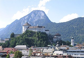
Kufstein is a town in the Austrian state of Tyrol, the administrative seat of Kufstein District. With a population of about 20,000 it is the second largest Tyrolean town after the state capital Innsbruck. The greatest landmark is Kufstein Fortress, first mentioned in the 13th century. The town was the place of origin of the Austrian noble family Kuefstein.
Fürth is a city in northern Bavaria, Germany, in the administrative division (Regierungsbezirk) of Middle Franconia.
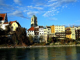
Wasserburg am Inn is a town in Rosenheim district in Upper Bavaria, Germany. The historic centre is a peninsula formed by the meandering river Inn. Many Medieval structures remain intact, giving the city a unique view.
Ebersberg is the seat of the similarly named Ebersberg Landkreis (district) in the Oberbayern Regierungsbezirk in Bavaria, southern Germany. The Ebersberger Forst (forest) is one of Germany’s largest continuous area of woodlands.
München Hauptbahnhof or Munich Central Station is the main railway station in the city of Munich, Germany. It is one of the three stations with long-distance services in Munich, the others being Munich East station and Munich-Pasing station (München-Pasing). München Hauptbahnhof sees about 450,000 passengers a day, which puts it on par with other large stations in Germany, such as Hamburg Hauptbahnhof and Frankfurt (Main) Hauptbahnhof. It is classified by Deutsche Bahn as a category 1 station, one of 21 in Germany and two in Munich, the other being München Ost. The mainline station is a terminal station with 32 platforms. The subterranean S-Bahn with 2 platforms and U-Bahn stations with 6 platforms are through stations.
Grafing bei München is a town in the district of Ebersberg, Upper Bavaria, Germany.
Munich East station is a railway station in Munich, the state capital of Bavaria, Germany. It opened as Haidhausen station in 1871 on the new Munich–Mühldorf and Munich–Rosenheim railway lines. The station is operated by DB Station&Service, a subsidiary of Deutsche Bahn AG. It is classified as a Category 1 station, one of 21 in Germany and two in Munich, the other being München Hauptbahnhof. It is the city's third interregional station besides München Hauptbahnhof in the city centre and München-Pasing in the west.
Pullach, officially Pullach i. Isartal, is a municipality in the district of Munich in Bavaria in Germany. It lies on the Isar Valley Railway and is served by the S 7 line of the Munich S-Bahn, at the Großhesselohe Isartalbahnhof, Pullach and Höllriegelskreuth railway stations.
Stephanskirchen is a municipality in the district of Rosenheim, Upper Bavaria in Germany.
Albaching is a municipality in the district of Rosenheim in Bavaria in Germany.
The Rosenheim–Kufstein railway is a 32 kilometre-long double-track main line of the German railways. It connects the Munich–Rosenheim and the Rosenheim–Salzburg lines at Rosenheim with the line to Innsbruck, thus connecting Germany, Salzburg and eastern Austria with Innsbruck and the Brenner line to Italy and the Arlberg line to far western Austria. The line is part of the Line 1 of Trans-European Transport Networks (TEN-T). It is electrified at 15 kV, 16.7 Hz.
Haidhausen is a quarter in Munich, Germany. It is now part of the borough of Au-Haidhausen.
The Deutsches Eck is the name given to the shortest and most convenient road and railway link between the Austrian metropolitan region of Salzburg and the Tyrolean Unterland with the state capital Innsbruck.
The Rosenheim–Salzburg railway is a continuous double track and electrified main line railway almost entirely within the German state of Bavaria. It is an international transport corridor, linking Rosenheim to Salzburg in Austria.
Mühldorf (Oberbayern) station is a railway junction and station in the district town of Mühldorf in the German state of Bavaria. The station has seven platform tracks and is classified by Deutsche Bahn as a category 4 station. The station is served by 105 passenger trains each day operated by the Südostbayernbahn and frequented by about 10,000 travellers. It is also the central station of the “Bavarian Chemical Triangle”. About 800 freight wagons are dispatched from it daily.
The Mühldorf–Freilassing railway is a major railway in Bavaria. The line, which is operated by the Südostbayernbahn (SOB), runs from Mühldorf to Freilassing in the German state of Bavaria.
The Grafing–Wasserburg railway is a 29.1 km long, wholly single-track branch line in Upper Bavaria. It was partly built between 1899 and 1905. It is also called the Filzenexpress, which refers to the former raised bog ) it crosses in the Ebrach valley.
Julius Mayr was a German physician, chairman of the German Alpine Club and writer who wrote a biography of the painter Wilhelm Leibl.
↑ Stefan Trux, Franz Hilger: Rosenheim – Tor zum Inntal. S. 12.
1 2 Rosenheim im Dritten Reich; Beiträge zur Stadtgeschichte, editor Kulturamt der Stadt Rosenheim 1989
↑ Georg Heinrich Kexser:: Elementar-Geographie des Königreichs Bayern zum Gebrauch der Schulen, München 1810, S. 90 (online)
↑ Franz Joseph von Klöckel: Rosenheim mit seiner Heilquelle und Umgegend im Jahre 1815 beschrieben. Band 1: Rosenheim mit seiner Heilquelle, München 1815, S. 19 (online).
↑ Adolph von Schaden: Alphabetisches Verzeichniß sämmtlicher im Isarkreise gelegenen Städte, Märkte, Dörfer, Weiler, Einöden usw. (Als Anhang zu dem topographisch=statistischen Handbuche für den Isarkreis des Königreichs Baiern, E-Kopie), München 1825, S. 412 (online)
↑ Adolph von Schaden: Topographisch=Statistisches Handbuch für den Isarkreis des Königreichs Baiern, gedruckt und verlegt auf Kosten der Königl. Regierung des Isarkreises, München 1825 (online).
↑ Bayerlacher: Kurze Beschreibung des königlich bayerischen Landgerichts Rosenheim und des gräflich Preysingischen Herrschafts-Gerichts Hohenaschau, München 1841, S. 82 (online).
↑ Meyers Großes Konversations-Lexikon. 6. Auflage, Band 17, Leipzig/Wien 1909, S. 150 (zeno.org).
↑ Rosenheim, Oberbayern, in: Meyers Gazetteer (mit Eintrag aus Meyers Orts- und Verkehrslexikon, Ausgabe 1912, und alter Landkarte der Umgebung von Rosenheim).
↑ Ludwig Gassner: Rosenheim und dessen Umgebung. Für Fremde und Einheimische unter besonderer Berücksichtigung des Heilbades Rosenheim. Rosenheim 1865 (online).
↑ "Städtepartnerschaften". rosenheim.de (in German). Rosenheim. 22 November 2016. Retrieved 16 March 2021.
This page is based on this Wikipedia article Text is available under the CC BY-SA 4.0 license; additional terms may apply. Images, videos and audio are available under their respective licenses.