
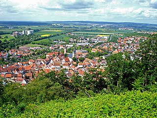
Kelheim is a town and municipality in Bavaria, Germany. It is the capital of the district Kelheim and is situated at the confluence of the rivers Altmühl and Danube. Kelheim has a population of around 16,750 (2020).

Oettingen in Bayern is a town in the Donau-Ries district, in Swabia, Bavaria, Germany. It is situated 29 km (18 mi) northwest of Donauwörth, and 14 km (8.7 mi) northeast of Nördlingen.

Hilpoltstein is a town in the district of Roth, in Bavaria, Germany. It is situated 10 km southeast of Roth bei Nürnberg and 30 km south of Nuremberg, close to the lake 'Rothsee.

Maisach is a municipality in the district of Fürstenfeldbruck, in Bavaria, Germany.
Zeil am Main is a town in the Haßberge district in Lower Franconia, an area in the federal state of Bavaria, Germany. It is situated on the right bank of the Main, 7 km east of Haßfurt, 24 km northwest of Bamberg, and 25 km east of Schweinfurt. Zeil is a historic Franconian town known for its old churches, romantic houses, medieval walls and towers, the hill church of "Zeiler Käpelle", and the castle ruins of the Schmachtenburg.

Ayinger Brewery is in Aying, Bavaria, Germany, about 25 km south of Munich. Ayinger beers are exported to Italy, the United States, and the rest of Europe.

Andechs is a municipality in the district of Starnberg in Bavaria in Germany. It is renowned in Germany and beyond for Andechs Abbey, a Benedictine monastery that has brewed beer since 1455. The monastery brewery offers tours to visitors.

Motten is a municipality in the district of Bad Kissingen in Bavaria in Germany.

Rattelsdorf is a municipality with market rights in the Upper Franconian district of Bamberg.
Zapfendorf is a municipality with market rights in the Upper Franconian district of Bamberg in Bavaria, Germany with roughly 5,000 inhabitants.

Altomünster is a municipality in the district of Dachau in Bavaria in Germany.

Odelzhausen is a town and municipality in the west of the district of Dachau in Upper Bavaria, Germany.

Pretzfeld is a municipality in the district of Forchheim in Bavaria in Germany.

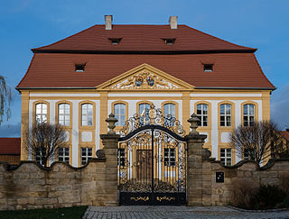
Herrngiersdorf is a municipality in the district of Kelheim in Bavaria in Germany. The village is dominated by the large, square Schloss Herrngiersdorf, a brewery.

Igling is a municipality in the district of Landsberg in Bavaria in Germany.

Heimenkirch is a municipality in the district of Lindau in Bavaria in Germany.

Valley is a municipality in the district of Miesbach in Bavaria in Germany. The municipality of Valley holds, as of 2006, 2949 inhabitants.

Otterfing is a municipality in the district of Miesbach in Bavaria in Germany.

Thalmässing is a municipality in the district of Roth, in Bavaria, Germany.
Ustersbach is a municipality in the district of Augsburg in Bavaria in Germany. It is situated approx. 20 kilometres (12 mi) west of Augsburg


