Unterhaching (German pronunciation:[ʔʊntɐˈhaxɪŋ]; Central Bavarian: Haching) is the second largest municipality in the district of Munich in Bavaria, Germany, located to the south of Munich city centre and easily accessible via two federal motorways, Bundesautobahn 8 and Bundesautobahn 995, and also on the Munich S-Bahn, connecting Unterhaching to Marienplatz in less than 20 minutes. The municipality is best known for its football club SpVgg Unterhaching, who played in the Bundesliga in 1999–2001 and is also home to a CO2 neutral district heating network.

Ottobrunn is a municipality southeast of Munich, Bavaria, Germany, founded in 1955. Ottobrunn consists of mainly semi-detached and detached houses, as well as extensive garden areas. Ottobrunn is also the German Headquarters of Airbus Defense and Space, with the majority of Airbus DS grounds situated in the neighbouring community of Taufkirchen. According to the Federal Statistical Office of Germany, the municipality is the second-most densely populated in all of Germany, trailing only Munich, and ahead of Berlin.

Ismaning is a municipality in Bavaria, Germany, located near Munich.

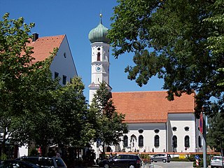
Oberhaching is a municipality in Bavaria, Germany, with 13,638 inhabitants (2020) on an area of 26.6 km2 (10.3 sq mi). It is located 15 km (9.3 mi) south of Munich city centre and has a 1,250 year history.

Nersingen is a municipality in the District of Neu-Ulm in Bavaria, Germany. The neighbours are Neu-Ulm, Elchingen, Bibertal and Pfaffenhofen an der Roth.
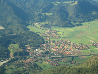
Marquartstein is a municipality in the southeastern part of Bavaria, Germany and is part of the Verwaltungsgemeinschaft Marquartstein and Staudach-Egerndach. It is situated in a region called Chiemgau, approximately 10 km south of Lake Chiemsee between Munich and Salzburg. Most of the area is situated in the valley of the river Tiroler Achen, which separates the village into two parts. Marquartstein is at the edge of the Alps. Its geographical location is 47°46′N12°28′E.

Unterföhring is a municipality in Upper Bavaria. It lies adjacent to the northeast side of Munich, and is one of the nearest suburbs to Munich's central district.
Karlsfeld is a municipality in the district of Dachau, and a suburb to Munich in Bavaria, Germany. During World War II, it was the location of a subcamp of Dachau concentration camp.

Neufahrn bei Freising is a municipality in the district of Freising, in Bavaria, Germany. It has about 20,000 inhabitants and is located near the river Isar, 12 km southwest of Freising and 20 km northeast of Munich.
Gräfelfing is a municipality in the district of Munich, in Bavaria, Germany. It is located 1 km west of Munich.
Kirchheim bei München is a municipality in the district of Munich, in Bavaria, Germany. It is located 14 km east of Munich (centre). As of 2023 it has a population of 14,030.

Herrieden is a town in the district of Ansbach and situated in the Middle Franconia region of Bavaria, Germany. It lies along the upper Altmühl river, about 9 km (6 mi) southwest of the city of Ansbach, 47 km southwest of the city of Nürnberg, 95 km east of Heilbronn and 144 km northwest of Munich.

Hirschbach is a municipality in the district of Amberg-Sulzbach in Bavaria in Germany.

Oberau is a municipality in the district of Garmisch-Partenkirchen, in Bavaria, Germany.

Weyarn is a municipality in the district of Miesbach in Bavaria in Germany.

Haag in Oberbayern is a municipality in the district of Mühldorf in Bavaria in Germany, in December 2013 the municipality had a population of 6359.

Baierbrunn is a municipality in the district of Munich in the south-German state Bavaria. It is located between Schäftlarn and Pullach on the Bundesstraße 11 and consists of the two villages Baierbrunn and Buchenhain. Baierbrunn has a stop on the S7 of the Munich S-Bahn.
Putzbrunn is a town in the district of Munich, Bavaria in Germany.
Ustersbach is a municipality in the district of Augsburg in Bavaria in Germany. It is situated approx. 20 kilometres (12 mi) west of Augsburg

Fürstenzell is a municipality in the district of Passau in Bavaria in Germany.