Passau (district)

Last updated
Passau
Flagge Landkreis Passau.svg
DEU Landkreis Passau COA.svg
Passau (district)
Country Germany
State Bavaria
Adm. region Lower Bavaria
Capital Passau
Government
  District admin.Raimund Kneidinger (CSU)
Area
  Total1,530.28 km2 (590.84 sq mi)
Population
 (31 December 2022) [1]
  Total196,963
  Density130/km2 (330/sq mi)
Time zone UTC+01:00 (CET)
  Summer (DST) UTC+02:00 (CEST)
Vehicle registration PA
Website www.landkreis-passau.de

Passau is a Landkreis (district) in the southeast of Bavaria, Germany. It encloses the city of Passau geographically from two sides. Neighboring districts are (from the east clockwise) Rottal-Inn, Deggendorf, Freyung-Grafenau. To the south it borders Austria.

Contents

History

Archaeological findings prove that the area was settled more than 7000 years ago. In 1971 the district was created by merging the previous districts Wegscheid, Vilshofen, Griesbach (Rottal) and parts of the districts Pfarrkirchen and Eggenfelden. The city's original name was Batava (also known as Batavia) in Roman times. Passau survived three major fires, the biggest one being the all-destructive fire from 1662. After much of the city had burned down, bishops rebuilt it in Baroque style. To this day, massive cathedrals such as the St. Stephan's Dom (Dom means "cathedral" in German) stun visitors from all over the world. St. Stephan houses the world's largest church organ.

Geography

The district consists of two geographically different parts, separated by the river Danube. In the north is the southern part of the Bayrischer Wald (Bavarian Forest) mountains with hills up to 1000 meters tall. In the south of the Danube river the landscape is only hilly with plains between the valleys of the Inn and Ilz river.

Coat of arms

The bottom of the coat of arms show the blue-and-white checkered symbol of Bavaria. In the top part is a red wolf and a red panther. The wolf represents the abbey of Passau (Hochstift Passau), which is now the central part of the district. The panther is the symbol of the Wittelsbach family, and it represents the area of the former districts Vilshofen and Griesbach.

Towns and municipalities

Clickable map of towns and municipalities in the district Municipalities in PA.svgTiefenbachOrtenburgHofkirchenBreitenberg
Clickable map of towns and municipalities in the district
Towns Verbandsgemeinden Municipalities
  1. Bad Griesbach (Rottal)
  2. Hauzenberg
  3. Pocking
  4. Vilshofen
  1. Aidenbach [lower-alpha 1]
  2. Rotthalmünster [lower-alpha 2]
  3. Tittling [lower-alpha 3]

Market towns (märkte)

  1. Aidenbach
  2. Eging am See
  3. Fürstenzell
  4. Hofkirchen
  5. Hutthurm
  6. Obernzell
  7. Ortenburg
  8. Rotthalmünster
  9. Tittling
  10. Untergriesbach
  11. Wegscheid
  12. Windorf
  1. Aicha vorm Wald
  2. Aldersbach
  3. Bad Füssing
  4. Beutelsbach
  5. Breitenberg
  6. Büchlberg
  7. Fürstenstein
  8. Haarbach
  9. Kirchham
  10. Kößlarn
  11. Malching
  12. Neuburg am Inn
  13. Neuhaus am Inn
  14. Neukirchen vorm Wald
  15. Ruderting
  16. Ruhstorf an der Rott
  17. Salzweg
  18. Sonnen
  19. Tettenweis
  20. Thyrnau
  21. Tiefenbach
  22. Witzmannsberg
Notes
  1. Aidenbach Verbandsgemeinde consists of the market town municipality of Aidenbach and the municipality of Beutelsbach.
  2. Rotthalmünster Verbandsgemeinde consists of the municipality of Malching and the market town municipality of Rotthalmünster.
  3. Tittling Verbandsgemeinde consists of the market town municipality of Tittling and the municipality of Witzmannsberg.

Related Research Articles

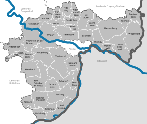
Altötting is a Landkreis (district) in Bavaria, Germany. It is bounded by Austria and the Bavarian districts of Traunstein, Mühldorf and Rottal-Inn.

<span class="mw-page-title-main">Passau</span> University town in Lower Bavaria, Germany

Passau is a city in Lower Bavaria, Germany. It is also known as the Dreiflüssestadt as the river Danube is joined by the Inn from the south and the Ilz from the north.

Deggendorf is a Landkreis (district) in Bavaria, Germany. It is bordered by the districts of Regen, Freyung-Grafenau, Passau, Rottal-Inn, Dingolfing-Landau and Straubing-Bogen.

Dingolfing-Landau is a Landkreis (district) in Bavaria, Germany. It is bounded by the districts of Straubing-Bogen, Deggendorf, Rottal-Inn and Landshut.

Freyung-Grafenau is a Landkreis (district) in Bavaria, Germany. It is bounded by the districts of Passau, Deggendorf and Regen, the Czech Republic and by Austria.

Landshut is a Landkreis (district) in Bavaria, Germany. It is bounded by the districts of Kelheim, Straubing-Bogen, Dingolfing-Landau, Rottal-Inn, Mühldorf, Erding and Freising. The city of Landshut is enclosed by, but does not belong to the district. It is nonetheless its administrative seat.

Rottal-Inn is a Landkreis (district) in the southeastern part of Bavaria, Germany. Neighboring districts are Altötting, Mühldorf, Landshut, Dingolfing-Landau and Passau. To the southeast is the Austrian state of Upper Austria (Braunau).

Straubing-Bogen is a Landkreis (district) in the eastern part of Bavaria, Germany. Neighboring districts are Cham, Regen, Deggendorf, Dingolfing-Landau, Landshut and Regensburg. The independent town of Straubing is surrounded by the district. The seat of the government of the district (Landratsamt) is located in Straubing.

<span class="mw-page-title-main">Aldersbach</span> Municipality in Bavaria, Germany

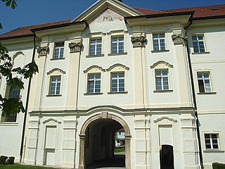
Aldersbach is a municipality in the district of Passau in Bavaria in Germany. The former Cistercian Aldersbach Abbey, of which the Baroque church remains, is located in the village. There is also a brewery with museum. Aldersbach has around 4,500 inhabitants.

<span class="mw-page-title-main">Zenting</span> Municipality in Bavaria, Germany

Zenting is a municipality in the district of Freyung-Grafenau in Bavaria in Germany.

<span class="mw-page-title-main">Bad Griesbach</span> Town in Bavaria, Germany

Bad Griesbach im Rottal, or just Bad Griesbach, is a town in the district of Passau in Bavaria in Germany.

<span class="mw-page-title-main">Neuburg am Inn</span> Municipality in Bavaria, Germany

Neuburg am Inn is a municipality in the district of Passau in Bavaria in Germany.

<span class="mw-page-title-main">Obernzell</span> Municipality in Bavaria, Germany

Obernzell is a municipality in the district of Passau in Bavaria in Germany.

<span class="mw-page-title-main">Ortenburg, Bavaria</span> Municipality in Bavaria, Germany

Ortenburg is a municipality and old market town in the district of Passau in Bavaria in Germany.

<span class="mw-page-title-main">Untergriesbach</span> Municipality in Bavaria, Germany

Untergriesbach is a municipality in the district of Passau in Bavaria in Germany.

<span class="mw-page-title-main">EV6 The Rivers Route</span> Cycling route in Europe

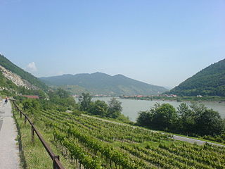
EuroVelo 6 (EV6), named the "Rivers Route", is a EuroVelo long-distance cycling route that runs along 3,653 km (2,270 mi) some of Europe's major rivers, including much of the Loire, some of the Saône, a short section of the upper Rhine and almost the entire length of Europe’s second longest river, the Danube — from the Atlantic coast of France to the city of Constanța on the Black Sea.

<span class="mw-page-title-main">Vilshofen–Ortenburg railway</span> Railway line in Bavaria, Germany

The Vilshofen –Ortenburg railway, also known as the Wolfach Valley Railway, is a branch line or Lokalbahn in the province of Lower Bavaria in southern Germany. It was opened on 16 January 1908 and closed to passenger services on 30 September 1962.

<span class="mw-page-title-main">Simbach am Inn–Pocking railway</span>

The Simbach am Inn–Pocking railway was a single-tracked branch line between Simbach am Inn and Pocking in the province of Lower Bavaria in southern Germany.

<span class="mw-page-title-main">Lower Danube Circle</span> 1806–1837 administrative district of the Kingdom of Bavaria

The Lower Danube Circle or Under Danube Circle was one of the administrative districts of the Kingdom of Bavaria between 1806 and 1837. It was named after its main river, the Danube and was the predecessor of the administrative district of Lower Bavaria. Its administrative headquarters were in Passau, but the appellate court was in Straubing.

<span class="mw-page-title-main">Neuburg Forest</span>

The Neuburg Forest is a largely forested hill ridge and natural region in Lower Bavaria in the county of Passau and the borough of Passau. It is named after the village of Neuburg am Inn.

References

48°30′N13°20′E / 48.5°N 13.33°E / 48.5; 13.33