Ortenburg, Bavaria

Last updated
Ortenburg, Bavaria
Ortenburg Marktplatz.JPG
Ortenburg town centre
DEU Ortenburg COA.svg
Location of Ortenburg, Bavaria within Passau district
Ortenburg in PA.svgTiefenbachOrtenburgHofkirchenBreitenberg
Germany adm location map.svg
Red pog.svg
Ortenburg, Bavaria
Bavaria location map.svg
Red pog.svg
Ortenburg, Bavaria
Coordinates: 48°32′N13°13′E / 48.533°N 13.217°E / 48.533; 13.217
Country Germany
State Bavaria
Admin. region Niederbayern
District Passau
Government
   Mayor (202026) Stefan Lang [1] (CSU)
Area
  Total60.73 km2 (23.45 sq mi)
Elevation
358 m (1,175 ft)
Population
 (2022-12-31) [2]
  Total7,437
  Density120/km2 (320/sq mi)
Time zone UTC+01:00 (CET)
  Summer (DST) UTC+02:00 (CEST)
Postal codes
94496
Dialling codes 08542
Vehicle registration PA
Website www.ortenburg.de

Ortenburg (Central Bavarian : Otnbuag) is a municipality and old market town in the district of Passau in Bavaria in Germany.

Contents

Geography

Geographical location

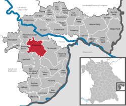
Ortenburg is situated in the forested area south of the Danube and north of the Rott. It is one of the main centres of population in the Lower Bavarian Upland. The majority of the municipality is located in the Wolfach Valley and the Wolfach itself runs directly through Ortenburg.

The market town lies 20 km west of Passau, 10 km south of Vilshofen an der Donau, 12 km northwest of Bad Griesbach and 20 km north of Pocking.

Neighbouring municipalities

The closest municipalities are Haarbach, Beutelsbach, Vilshofen an der Donau, Fürstenzell, and Bad Griesbach im Rottal. The cities of Passau and Pocking are somewhat farther away.

Administrative division

The municipality of Ortenburg includes 112 districts. [3]

History

The Ortenburg Market in 1620, from a watercolour by Friedrich Casimir. Ortenburg-1620.jpg
The Ortenburg Market in 1620, from a watercolour by Friedrich Casimir.

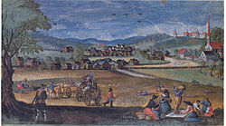
Set in the Wolfach River valley, Ortenburg can look back over a 900-year history. In about 1120 it was established by the Counts of Ortenburg (De). At the same time, the upwardly mobile von Kamm family appeared on the scene. However, during the thirteenth century, the von Kamms relocated to Hals (now a quarter of Passau). The Ortenburg counts, whose own origins lay with the Spanheimer dynasty, were keen to establish their own separate dynastic centre and such the Imperial County of Ortenburg kept its Imperial immediacy until 1806.

The Ortenburgs were among the most powerful of the Bavarian nobility, competing in terms of power and position with the Wittelsbach dynasty. During the height of their power, during the twelfth and thirteenth centuries, the Ortenburgs held lands from as far south as the Brixen valley, that extended also far into the Upper Palatinate.

Smuggling

Smuggling across the border Bibles (Martin Luther) to Habsburg: Hans Ungnad von Weißenwolff, Freiherr von Sonneck, Hans III (1493–1564), famous Bible printer and smuggler in Bad Urach [4] Smuggler, translator and Slovene refugee Protestant preacher Primož Trubar, who published the first books in Slovene and is regarded as the key consolidator of the Slovene identity, lived in Tübingen Derendingen. In The Free Imperial City (German: Freie Reichsstadt) bibles and the Ortenburger Ratschlag was produced.

Krypto Protestants

The original chalice in the protestant worship is still in use in Ortenburg. In this time the church of Ortemburg was the only reachable protestant church outside the border Crypto-Protestantism of Habsburg Empire.

Mostbauern

The Mostbauern of Ortenburg (orchard meadow farmers) came as grower and cellar master protestant refugees from Austria.

Notable residents

Related Research Articles

Passau is a Landkreis (district) in the southeast of Bavaria, Germany. It encloses the city of Passau geographically from two sides. Neighboring districts are Rottal-Inn, Deggendorf, Freyung-Grafenau. To the south it borders Austria.

<span class="mw-page-title-main">Vilshofen an der Donau</span> Town in Bavaria, Germany

Vilshofen an der Donau is the largest city in the southeast of Bavaria, Germany in the district of Passau. Until 1972, the town was the district seat of the district of Vilshofen.

<span class="mw-page-title-main">Neustadt an der Donau</span> Town in Bavaria, Germany

Neustadt an der Donau is a town in Lower Bavaria on the Danube in Bavaria, Germany. Lying on the western border of Landkreis Kelheim, Neustadt is primarily known for the thermal spa Bad Gögging. Neustadt had a population of 12,753 as of December 31, 2003.

<span class="mw-page-title-main">Aldersbach</span> Municipality in Bavaria, Germany

Aldersbach is a municipality in the district of Passau in Bavaria in Germany. The former Cistercian Aldersbach Abbey, of which the Baroque church remains, is located in the village. There is also a brewery with museum. Aldersbach has around 4,500 inhabitants.

<span class="mw-page-title-main">Pöcking</span> Municipality in Bavaria, Germany

Pöcking is a municipality in the district of Starnberg in Bavaria, Germany. It is best known for being the location of Duchess Elisabeth in Bavaria's childhood summer home, Possenhofen Castle.

<span class="mw-page-title-main">Pocking</span> Town in Bavaria, Germany

Pocking is a town in the district of Passau, in Lower Bavaria, Germany. It is situated about 30 km south-west of Passau, close to the Austrian border.

<span class="mw-page-title-main">Münsing</span> Municipality in Bavaria, Germany

Münsing is a municipality in the district of Bad Tölz-Wolfratshausen in Bavaria in Germany.

<span class="mw-page-title-main">Kaisheim</span> Municipality in Bavaria, Germany

Kaisheim is a municipality in the district of Donau-Ries in Bavaria in Germany. It was the location of Kaisheim Abbey.

<span class="mw-page-title-main">Haidmühle</span> Municipality in Bavaria, Germany

Haidmühle is a municipality in the district of Freyung-Grafenau in Bavaria in Germany.

<span class="mw-page-title-main">Zenting</span> Municipality in Bavaria, Germany

Zenting is a municipality in the district of Freyung-Grafenau in Bavaria in Germany.

<span class="mw-page-title-main">Saal an der Donau</span> Place in Bavaria, Germany

Saal is a municipality in the district of Kelheim in Bavaria in Germany. It is located along the banks of the Danube River, around 25 km southwest of Regensburg.

<span class="mw-page-title-main">Bad Füssing</span> Municipality in Bavaria, Germany

Bad Füssing is a municipality in the district of Passau in Bavaria in Germany. Located some 3 km from the river Inn, which creates a border to Austria.

<span class="mw-page-title-main">Bad Griesbach</span> Town in Bavaria, Germany

Bad Griesbach im Rottal, or just Bad Griesbach, is a town in the district of Passau in Bavaria in Germany.

<span class="mw-page-title-main">Kirchham</span> Municipality in Bavaria, Germany

Kirchham is a municipality in the district of Passau in Bavaria in Germany.

<span class="mw-page-title-main">Neuburg am Inn</span> Municipality in Bavaria, Germany

Neuburg am Inn is a municipality in the district of Passau in Bavaria in Germany.

<span class="mw-page-title-main">Sonnen</span> Municipality in Bavaria, Germany

Sonnen is a small municipality in the district of Passau in Bavaria in Germany. It is located in the Danube forest, lower Bavarian forest and is located mostly in the district Passau at a height of 700 to 900 meters. Sonnen lies 28 km from Passau, 9 km from Hauzenberg and from the forest itself 13 km. Sonnen borders with upper Austria which lies only 8 km away.

<span class="mw-page-title-main">Tiefenbach, Passau</span> Municipality in Bavaria, Germany

Tiefenbach is a municipality in the district of Passau in Bavaria in Germany.

<span class="mw-page-title-main">Obernzell</span> Municipality in Bavaria, Germany

Obernzell is a municipality in the district of Passau in Bavaria in Germany.

<span class="mw-page-title-main">Untergriesbach</span> Municipality in Bavaria, Germany

Untergriesbach is a municipality in the district of Passau in Bavaria in Germany.

<span class="mw-page-title-main">Vilshofen–Ortenburg railway</span> Railway line in Bavaria, Germany

The Vilshofen –Ortenburg railway, also known as the Wolfach Valley Railway, is a branch line or Lokalbahn in the province of Lower Bavaria in southern Germany. It was opened on 16 January 1908 and closed to passenger services on 30 September 1962.

References

  1. Liste der ersten Bürgermeister/Oberbürgermeister in kreisangehörigen Gemeinden, Bayerisches Landesamt für Statistik, 15 July 2021.
  2. Genesis Online-Datenbank des Bayerischen Landesamtes für Statistik Tabelle 12411-003r Fortschreibung des Bevölkerungsstandes: Gemeinden, Stichtag (Einwohnerzahlen auf Grundlage des Zensus 2011).
  3. "Bayerische Landesbibliothek Online (BLO)". www.bayerische-landesbibliothek-online.de (in German). Retrieved 2017-03-09.
  4. Smuggler in German
Ortenburg Castle Schloss Ortenburg.jpg
Ortenburg Castle