Lower Bavarian Upland

Last updated
In the Lower Bavarian Hills Niederbayerisches Hugelland.JPG
In the Lower Bavarian Hills

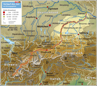
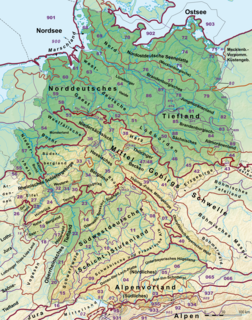
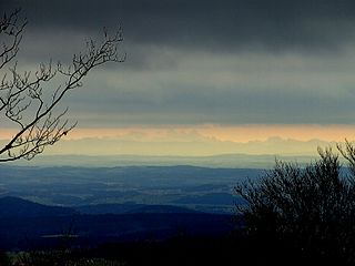
The Lower Bavarian Upland, Lower Bavarian Hill Country (German: Niederbayerisches Hügelland) or Lower Bavarian Hills, are part of the tertiary Hügelland or hill country [1] south of the River Danube and cover much of the land within the Bavarian province of Lower Bavaria in southern Germany. To the north it is bordered by the Gäuboden region and the Bavarian Forest; to the south by Upper Bavaria, to the east by the Lower Inn Valley and to the west by the Franconian Jura (Fränkische Alb). In the western part of the Lower Bavarian Hills lies the Hallertau, the world's largest hop-growing region. [2] It belongs to two of officially defined natural regions in Germany: the eponymous Lower Bavarian hills and the Isar-Inn Gravel Beds (Isar-Inn-Schotterplatten) and is sub-divided into the Danube-Isar Hills (Donau-Isar-Hügelland) and the Isar-Inn Upland (Isar-Inn-Hügelland) with the River Isar as the boundary. The hills continue over the border into Austria as the Upper Austrian Hills (Oberösterreichischen Hügelland).

Hügelland is a type of landscape consisting of low, rolling hills whose topography or surface structure lies between that of a lowland region and that of a more rugged hill range or low mountain range. The term is German and has no exact equivalent in English, but is often translated as "hill country", "hilly terrain", "upland(s)" or "gently undulating" or "rolling country", or "rolling countryside". It is derived from Hügel, a low hill or hillock and appears frequently as a proper name for this type of terrain.

Lower Bavaria adminstrative region in Bavaria, Germany

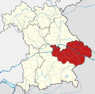
Lower Bavaria is one of the seven administrative regions of Bavaria, Germany, located in the east of the state.

Germany Federal parliamentary republic in central-western Europe

Germany, officially the Federal Republic of Germany, is a country in Central and Western Europe, lying between the Baltic and North Seas to the north, and the Alps, Lake Constance and the High Rhine to the south. It borders Denmark to the north, Poland and the Czech Republic to the east, Austria and Switzerland to the south, France to the southwest, and Luxembourg, Belgium and the Netherlands to the west.

The larger centres of population in the Lower Bavarian Upland are Landau an der Isar, Pfarrkirchen, Eggenfelden, Bad Griesbach im Rottal, Ortenburg, Triftern, Rottenburg an der Laaber and Pfeffenhausen. The Lower Bavarian Spa Triangle (Niederbayerisches Bäderdreieck) is of particularly importance for tourism.

Landau an der Isar Place in Bavaria, Germany

Landau an der Isar is the second largest town in the Lower Bavarian district, or Landkreis, of Dingolfing-Landau, in the state of Bavaria, Germany. It lies on the river Isar. In 2005, the population was around 12,950.

Pfarrkirchen Place in Bavaria, Germany

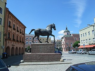
Pfarrkirchen is a municipality in southern Lower Bavaria Germany, the capital of the district Rottal-Inn. It has about 12,500 inhabitants and is an important school centre with about 10,000 pupils from all over Lower Bavaria. The town spreads over an area of about 52 square kilometers and lies approximately 377 meters above sea level. Pfarrkirchen lies at the small river "Rott", which gives the "Rottal" region its name. One of Pfarrkirchen's important industries include abattoirs which is due to the rural environment.

Related Research Articles

Upper Austria State of Austria

Upper Austria is one of the nine states or Bundesländer of Austria. Its capital is Linz. Upper Austria borders on Germany and the Czech Republic, as well as on the other Austrian states of Lower Austria, Styria, and Salzburg. With an area of 11,982 km2 (4,626 sq mi) and 1.437 million inhabitants, Upper Austria is the fourth-largest Austrian state by land area and the third-largest by population.

Bavarian language Major group of Upper German varieties spoken in the southeast of the German language area Bavaria

Bavarian is a West Germanic language belonging to the Upper German group, spoken in the southeast of the German language area, much of Bavaria, most of Austria and South Tyrol in Italy, as well as Samnaun in Switzerland. Before 1945, Bavarian was also prevalent in parts of the southern Czech Republic and western Hungary. It forms a continuum of more or less mutually intelligible local and regional variants.

Upper Bavaria Regierungsbezirk in Bavaria, Germany

Upper Bavaria is one of the seven administrative districts of Bavaria, Germany.

Upper Palatinate Regierungsbezirk in Bavaria, Germany

The Upper Palatinate is one of the seven administrative districts of Bavaria, Germany, located in the east of Bavaria.

Altötting (district) District in Bavaria, Germany

Altötting is a Landkreis (district) in Bavaria, Germany. It is bounded by Austria and the Bavarian districts of Traunstein, Mühldorf and Rottal-Inn.

Inn (river) river in Switzerland, Austria and Germany, a right tributary of the Danube

The Inn is a river in Switzerland, Austria and Germany. It is a right tributary of the Danube and is 518 kilometres (322 mi) long. The highest point of its drainage basin is the summit of Piz Bernina, at 4,049 metres (13,284 ft). The Engadine, the valley of the En, is the only Swiss valley whose waters end up in the Black Sea.

Salzach river in Austria and Germany

The Salzach is a river in Austria and Germany. It is a right tributary of the Inn and is 227 kilometres (141 mi) in length, its flow eventually joins the Danube. Its drainage basin of 6,829 km2 (2,637 sq mi) comprises large parts of the Northern Limestone and Central Eastern Alps. 83% of its drainage basin lies in Austria, the remainder in Germany (Bavaria). Its largest tributaries are Lammer, Berchtesgadener Ache, Saalach, Sur and Götzinger Achen.

Bavarian Forest low-mountain range in Bavaria, Germany

The Bavarian Forest is a wooded, low-mountain region in Bavaria, Germany that is about 100 kilometres long. It runs along the Czech border and is continued on the Czech side by the Bohemian Forest. Most of the Bavarian Forest lies within the province of Lower Bavaria, but the northern part lies within Upper Palatinate. In the south it reaches the border with Upper Austria.

Deggendorf (district) District in Bavaria, Germany

Deggendorf is a Landkreis (district) in Bavaria, Germany. It is bordered by the districts of Regen, Freyung-Grafenau, Passau, Rottal-Inn, Dingolfing-Landau and Straubing-Bogen.

Dingolfing-Landau District in Bavaria, Germany

Dingolfing-Landau is a Landkreis (district) in Bavaria, Germany. It is bounded by the districts of Straubing-Bogen, Deggendorf, Rottal-Inn and Landshut.

Innviertel geographic region

The Innviertel is a traditional Austrian region southeast of the Inn river. It forms the western part of the state of Upper Austria and borders the German state of Bavaria. The Innviertel is one of the four traditional "quarters" of Upper Austria, the others being Hausruckviertel, Mühlviertel, and Traunviertel.

Bavarian State Archaeological Collection

The Bavarian State Archaeological Collection in Munich is the central museum of prehistory of the State of Bavaria, considered to be one of the most important archaeological collections and cultural history museums in Germany.

Natural regions of Germany

This division of Germany into major natural regions takes account primarily of geomorphological, geological, hydrological, and pedological criteria in order to divide the country into large, physical units with a common geographical basis. Political boundaries play no part in this, apart from defining the national border.

Alpine Foreland geographic region

The Alpine Foreland, less commonly called the Bavarian Foreland, Bavarian Plateau or Bavarian Alpine Foreland, refers to a triangular region of plateau and rolling foothills in Southern Germany, stretching from Lake Constance in the west to beyond Linz on the Danube in the east, with the Bavarian Alps forming its south boundary and the Danube its northern extent.

Iller-Lech Plateau

The Iller-Lech Plateau, also known as the Upper Swabian Plateau, is one of the natural regions of Germany.

Bavarian Forest Nature Park nature park in Bavaria, Germany

The Bavarian Forest Nature Park covers an area north of the Danube as far as the border ridge with the Czech Republic. Its sponsor organisation is the Naturpark Bayerischer Wald whose head office is in Zwiesel, Bavaria. It was established in 1967 and is thus the oldest nature parks in Bavaria. It should not be confused with the Bavarian Forest National Park.

Neuburg Forest mountains in Germany

The Neuburg Forest is a largely forested hill ridge and natural region in Lower Bavaria in the county of Passau and the borough of Passau. It is named after the village of Neuburg am Inn.

Tertiary Hill Country

The Tertiary Hill Country, also called the Tertiary Hills, is an upland area with a moderate climate in the northern Alpine Foreland, which extends northwards as far as the River Danube. It is divided into two simple contiguous regions that are separated by the valley of the Lower Inn which itself is not usually counted as part of the Tertiary Hills. In Germany (Bavaria), the Lower Bavarian Upland is its larger northwestern element; in Upper Austria it forms the Hausruckviertl Mountain and Hill Country. From a natural regional perspective, depending on the definition, it forms one or two 3rd level natural regions.

References

  1. Dickinson, Robert E. (1964). Germany: A regional and economic geography (2nd ed.). London: Methuen.
  2. Bentley, James; Catling, Christopher; & Locke, Tim (1994). Munich and Bavaria. Chicago: Passport Books.

Sources

International Standard Book Number Unique numeric book identifier

The International Standard Book Number (ISBN) is a numeric commercial book identifier which is intended to be unique. Publishers purchase ISBNs from an affiliate of the International ISBN Agency.

Coordinates: 48°37′28″N12°19′58″E / 48.6244°N 12.3328°E / 48.6244; 12.3328

Geographic coordinate system Coordinate system

A geographic coordinate system is a coordinate system that enables every location on Earth to be specified by a set of numbers, letters or symbols. The coordinates are often chosen such that one of the numbers represents a vertical position and two or three of the numbers represent a horizontal position; alternatively, a geographic position may be expressed in a combined three-dimensional Cartesian vector. A common choice of coordinates is latitude, longitude and elevation. To specify a location on a plane requires a map projection.