Tiefenbach, Passau

Last updated

Tiefenbach
Pfarrkirche Tiefenbach.JPG
Parish church of Saint Margaret
DEU Tiefenbach COA.svg
Coat of arms
Location of Tiefenbach within Passau district
Tiefenbach in PA.svg
Germany adm location map.svg
Red pog.svg
Tiefenbach
Bavaria location map.svg
Red pog.svg
Tiefenbach
Coordinates: 48°37′N13°24′E / 48.617°N 13.400°E / 48.617; 13.400 Coordinates: 48°37′N13°24′E / 48.617°N 13.400°E / 48.617; 13.400
Country Germany
State Bavaria
Admin. region Niederbayern
District Passau
Government
   Mayor (201824) Christian Fürst [1] (CSU)
Area
  Total49.67 km2 (19.18 sq mi)
Elevation
373 m (1,224 ft)
Population
 (2020-12-31) [2]
  Total6,778
  Density140/km2 (350/sq mi)
Time zone UTC+01:00 (CET)
  Summer (DST) UTC+02:00 (CEST)
Postal codes
94113
Dialling codes 08509
Vehicle registration PA
Website www.gemeinde-tiefenbach.de

Tiefenbach is a municipality in the district of Passau in Bavaria in Germany.

Contents

Geography

Tiefenbach lies in the Danube Forest region, in one of the southernmost foothills of the Bavarian Forest northwest of Ilz and north of Danube on Bundesstraße 85. Tiefenbach is located only 9 km north of the university and three-river city Passau.

History

Until the church is planted

Tiefenbach was already early in the possession of the bishops of Passau, who left it to the Counts of Hals and other noble families as fiefs. The Sünzl von Söldenau family had been associated with the Hofmark since 1613 and were located at Schloss Weideneck near Tiefenbach. In 1690 the Hofmark was sold by Jakob Ferdinand Graf von Thun and Hohenstein to the Bishop of Passau, Tiefenbach henceforth belonged to the Hochstift Passau. With the Reichsdeputationshauptschlus of 1803 the place came to Bavaria. Tiefenbach was one of the few parts of the Hochstift that fell to Bavaria as early as 1803. The political community was founded in 1818.

19th century

Since the old church was dilapidated, the present church was built from 1842 to 1844 and consecrated on 12 October 1848 in honour of St. Margaret. In 1855 the village had 16 houses in addition to the parish church.

Incorporations

Haselbach, Kirchberg and Tiefenbach were independent communities from 1818 to 1971/1972. On 1 January 1972 Haselbach was incorporated into the municipality of Tiefenbach. The greater part of the municipality of Kirchberg was added on 1 July 1972. The rest of the municipality Kirchberg with the district Schalding on the left side of the Danube and Minihof (formerly Mimming) was incorporated into the city of Passau and there added to the newly formed district Hacklberg.

Population development

Related Research Articles

Passau is a Landkreis (district) in the southeast of Bavaria. It encloses the city of Passau geographically from two sides. Neighboring districts are Rottal-Inn, Deggendorf, Freyung-Grafenau. To the south it borders Austria.

Freyung-Grafenau is a Landkreis (district) in Bavaria, Germany. It is bounded by the districts of Passau, Deggendorf and Regen, the Czech Republic and by Austria.

Kissing, Bavaria Place in Bavaria, Germany

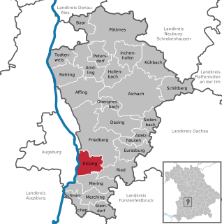
Kissing is a municipality in the Aichach-Friedberg district, in Bavaria, Germany. It is located just 10 km south of Augsburg and has about 11,200 inhabitants (2007).

Aldersbach Place in Bavaria, Germany

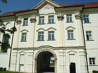
Aldersbach is a municipality in the district of Passau in Bavaria in Germany. The former Cistercian Aldersbach Abbey, of which the Baroque church remains, is located in the village. There is also a brewery with museum. Aldersbach has around 4,500 inhabitants.

Vilsbiburg Place in Bavaria, Germany

Vilsbiburg is a town on the river Große Vils, 18 km southeast of Landshut, in the district of Landshut, in Bavaria, Germany. The city owes its name to the river Große Vils which runs through Vilsbiburg. As of 2019 Vilsbiburg has 12,203 inhabitants.

Freyung, Bavaria Place in Bavaria, Germany

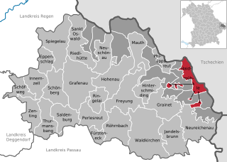
Freyung is a town in Bavaria, Germany, capital of the Freyung-Grafenau district. It is situated in the Bavarian Forest mountain range, near the border with Austria and the Czech Republic.

Seßlach Place in Bavaria, Germany

Seßlach is a town in the district of Coburg, in northern Bavaria, Germany. It is situated 12 km southwest of Coburg and has a population close to 4,000.

Lenggries Place in Bavaria, Germany

Lenggries is a municipality and a town in Bavaria, Germany. It is the center of the Isarwinkel, the region along the Isar between Bad Tölz and Wallgau. The town has about 9,500 inhabitants. By area, it is the largest rural municipality ("Gemeinde") in what was formerly West Germany, and the 7th-largest overall.

Lalling Place in Bavaria, Germany

Lalling is a municipality in the Lower Bavarian district of Deggendorf in Germany. It is a nationally recognized resort town.

Gößweinstein Place in Bavaria, Germany

Gößweinstein is a municipality in the district of Forchheim in Bavaria in Germany. It lies within the region known as Franconian Switzerland.

Haidmühle Place in Bavaria, Germany

Haidmühle is a municipality in the district of Freyung-Grafenau in Bavaria in Germany.

Althegnenberg Place in Bavaria, Germany

Althegnenberg is a municipality in the district of Fürstenfeldbruck in Bavaria in Germany.

Eching am Ammersee Place in Bavaria, Germany

Eching am Ammersee is a municipality in the district of Landsberg in Bavaria in Germany. It has a size of 6.15km2.

Neuburg am Inn Place in Bavaria, Germany

Neuburg am Inn is a municipality in the district of Passau in Bavaria in Germany.

Mitterskirchen Place in Bavaria, Germany

Mitterskirchen is a municipality in the district of Rottal-Inn in Bavaria in Germany.

Obernzell Place in Bavaria, Germany

Obernzell is a municipality in the district of Passau in Bavaria in Germany.

Ortenburg (Bavaria) Place in Bavaria, Germany

Ortenburg is a municipality and old market town in the district of Passau in Bavaria in Germany.

Tittling Place in Bavaria, Germany

Tittling is a municipality in the district of Passau in Bavaria in Germany.

Untergriesbach Place in Bavaria, Germany

Untergriesbach is a municipality in the district of Passau in Bavaria in Germany.

Haselbach, Bavaria Place in Bavaria, Germany

Haselbach is a municipality in the district of Straubing-Bogen in Bavaria, Germany.

References

  1. Liste der ersten Bürgermeister/Oberbürgermeister in kreisangehörigen Gemeinden, Bayerisches Landesamt für Statistik, accessed 19 July 2021.
  2. "Tabellenblatt "Daten 2", Statistischer Bericht A1200C 202041 Einwohnerzahlen der Gemeinden, Kreise und Regierungsbezirke". Bayerisches Landesamt für Statistik und Datenverarbeitung (in German). June 2021.