Untergriesbach

Last updated

Untergriesbach
Untergriesbach Marktplatz.jpg
Market square
Wappen Untergriesbach.svg
Location of Untergriesbach within Passau district
Untergriesbach in PA.svg
Germany adm location map.svg
Red pog.svg
Untergriesbach
Bavaria location map.svg
Red pog.svg
Untergriesbach
Coordinates: 48°34′30″N13°40′5″E / 48.57500°N 13.66806°E / 48.57500; 13.66806 Coordinates: 48°34′30″N13°40′5″E / 48.57500°N 13.66806°E / 48.57500; 13.66806
Country Germany
State Bavaria
Admin. region Niederbayern
District Passau
Government
   Mayor (2018–2024) Hermann Duschl [1]
Area
  Total73.60 km2 (28.42 sq mi)
Elevation
556 m (1,824 ft)
Population
 (2020-12-31) [2]
  Total6,070
  Density82/km2 (210/sq mi)
Time zone UTC+01:00 (CET)
  Summer (DST) UTC+02:00 (CEST)
Postal codes
94107
Dialling codes 08593
Vehicle registration PA
Website www.untergriesbach.de

Untergriesbach (Central Bavarian : Untagriasbo) is a municipality in the district of Passau in Bavaria in Germany.

Contents

Geography

Untergriesbach is located in the southern Bavarian Forest and extends high above the deep valley of the Danube. The height of the market town is 565 meters above sea level. Via the Bundesstraße 388 it is connected to Passau (22 km) and in the opposite direction to the Upper Austrian Haslach (32 km).

Untergriesbach in Passau district Untergriesbach in PA.svg
Untergriesbach in Passau district

History

The name comes from the nobles of Griesbach. These were a rich noble family with numerous possessions in the "land of the Abbey" (Passauer Abbey Country). Nothing remains from the former castle.

Originally it was named "Griespach", then "Griesbach on high market" (to distinguish it from "Griesbach in the cell" = Obernzell) and finally renamed in 1806 to Untergriesbach (to distinguish it from Bad Griesbach in the Rott Valley).

The nobles of Griesbach died out in the early 13th century. Their successors were the Wessenberger who possessed an extended property as a fief of the Bishopric Passau. The castle was probably destroyed after the death of the last Wessenberger around 1240.

Organ in St Michael's Church St.Michael - Orgelempore Gesamt.jpg
Organ in St Michael's Church

1260 Bishop Otto of Lonsdorf (approx. 1200–1265) gave the rights to hold a market and other privileges. During the Passau citizens revolt against Bishop Albert III. von Winkel (died 1380) Untergriesbach was burned down 1367 by insurgents from Passau. In 1456 Bishop Ulrich of Nussdorf confirmed and extended the rights and freedoms of the market.

Untergriesbach was largely spared from Thirty Years' War, but the Bavarian and Imperial troops, who were billeted here, imported in 1648 the plague during the last year of the war, which raged until early 1650 with great violence.

Gothic parish church of St. Michael Pfarrkirche Untergriesbach.JPG
Gothic parish church of St. Michael

The late Gothic parish church of St. Michael was remodeled baroque in several stages during the 18th century. In 1803 the market Griesbach came to Ferdinand III, Grand Duke of Tuscany (1769–1824) and 1806 to Kingdom of Bavaria. The trader Georg Saxinger was elected the first mayor. 1829 a new school building was erected, from 1829 to 1830 was built a new road to Obernzell, which was much more comfortable to drive than the old mountain road.

In 1903 the name of the municipality Griesbach was officially changed to Untergriesbach. [3] 1956 was built in the area of the municipality the water power plant Jochenstein.

Jochenstein power plant 2012 Kraftwerk Jochenstein AUT-GER, August 2012.jpg
Jochenstein power plant 2012

Municipality arrangement

Untergriesbach has 106 districts: [4]

Incorporations

On 1 October 1971, the previously independent municipality Lambsdorf was incorporated. On 1 January 1972 Gottsdorf and Schaibing were added. Oberötzdorf followed on 1 March 1972. [3]

Transport

A railway terminal was built in 1904 in Schaibing, located at the Passau-Hauzenberg railway. On this route the passenger transport ended in 1970, the freight transport ended in 1997. There are efforts to reactivate this route.

In 1912 Untergriesbach got connected to the Passau–Hauzenberg railway by a Rack railway. Rail traffic ceased in 1965, in 1975 the track Obernzell-Wegscheid was removed.

Town council

The town council has been elected in the local elections on 2 March 2008 as follows:

Crest

Blazon: "Argent, a left-facing rising red wolf."

Educational institutions

Culture

Attractions

Ruin of Neujochenstein Castle Burgruine Neujochenstein GO-3.jpg
Ruin of Neujochenstein Castle

People from Untergriesbach

Sports and teams

Related Research Articles

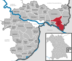
Passau is a Landkreis (district) in the southeast of Bavaria. It encloses the city of Passau geographically from two sides. Neighboring districts are Rottal-Inn, Deggendorf, Freyung-Grafenau. To the south it borders Austria.
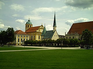
Neuburg an der Donau Town in Bavaria, Germany

Neuburg an der Donau, is a town which is the capital of the Neuburg-Schrobenhausen district in the state of Bavaria in Germany.

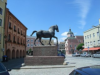
Pfarrkirchen is a municipality in southern Lower Bavaria Germany, the capital of the district Rottal-Inn. It has about 12,500 inhabitants and is an important school centre with about 10,000 pupils from all over Lower Bavaria. The town spreads over an area of about 52 square kilometers and lies approximately 377 meters above sea level. Pfarrkirchen lies at the small river "Rott", which gives the "Rottal" region its name. One of Pfarrkirchen's important industries include abattoirs which is due to the rural environment.

Waldkirchen Town in Bavaria, Germany

Waldkirchen is the biggest town in the district of Freyung-Grafenau in Germany.
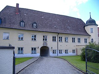
Waldsassen Town in Bavaria, Germany

Waldsassen is a town in the district of Tirschenreuth in the Upper Palatinate region of Bavaria.

Hauzenberg Town in Bavaria, Germany

Hauzenberg is a municipality in the district of Passau, in Bavaria, Germany. It is situated 15 kilometres northeast of Passau.

Mering Municipality in Bavaria, Germany

Mering is a municipality in the district Aichach-Friedberg, in Bavaria, Germany. It is located on the river Paar.

Freyung, Bavaria Town in Bavaria, Germany

Freyung is a town in Bavaria, Germany, capital of the Freyung-Grafenau district. It is situated in the Bavarian Forest mountain range, near the border with Austria and the Czech Republic.

Wallerstein, Bavaria Municipality in Bavaria, Germany

Wallerstein is a municipality and former principality in the district of Donau-Ries in Bavaria in Germany.

Biberbach, Bavaria Municipality in Bavaria, Germany

Biberbach is a municipality in the northern part of the district of Augsburg in Bavaria in Germany. A famous baroque pilgrimage church is located on the hill above the village.

Vierkirchen Municipality in Bavaria, Germany

Vierkirchen is a municipality in the district of Dachau in Bavaria in Germany.

Wiesentheid Municipality in Bavaria, Germany

Wiesentheid is a municipality in the district of Kitzingen in Bavaria in Germany.

Bad Griesbach Town in Bavaria, Germany

Bad Griesbach im Rottal, or just Bad Griesbach, is a town in the district of Passau in Bavaria in Germany.

Neuburg am Inn Municipality in Bavaria, Germany

Neuburg am Inn is a municipality in the district of Passau in Bavaria in Germany.

Sonnen Municipality in Bavaria, Germany

Sonnen is a small municipality in the district of Passau in Bavaria in Germany. It is located in the Danube forest, lower Bavarian forest and is located mostly in the district Passau at a height of 700 to 900 meters. Sonnen lies 28 km from Passau, 9 km from Hauzenberg and from the forest itself 13 km. Sonnen borders with upper Austria which lies only 8 km away.

Tiefenbach, Passau Municipality in Bavaria, Germany

Tiefenbach is a municipality in the district of Passau in Bavaria in Germany.

Seefeld, Bavaria Municipality in Bavaria, Germany

Seefeld is a municipality in the district of Starnberg in Bavaria, Germany. The town lies on the western shore of the Pilsensee. It is connected to the Bavarian capital city of Munich by the S-Bahn line S8. Seefeld is notable for the Seefeld Castle, a seat of the Toering noble family of Bavaria.

Hutthurm municipality in Bavaria, Germany

Hutthurm is a municipality in the district of Passau in Bavaria in Germany.

Obernzell Municipality in Bavaria, Germany

Obernzell is a municipality in the district of Passau in Bavaria in Germany.

Ortenburg (Bavaria) Municipality in Bavaria, Germany

Ortenburg is a municipality and old market town in the district of Passau in Bavaria in Germany.
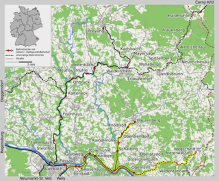
References

Commons-logo.svg Media related to Untergriesbach at Wikimedia Commons

  1. Liste der ersten Bürgermeister/Oberbürgermeister in kreisangehörigen Gemeinden, Bayerisches Landesamt für Statistik, accessed 19 July 2021.
  2. "Tabellenblatt "Daten 2", Statistischer Bericht A1200C 202041 Einwohnerzahlen der Gemeinden, Kreise und Regierungsbezirke". Bayerisches Landesamt für Statistik (in German). June 2021.
  3. 1 2 Wilhelm Volkert (1983), Handbuch der bayerischen Ämter, Gemeinden und Gerichte 1799–1980 (in German), München: C.H.Beck'sche Verlagsbuchhandlung, p. 590, ISBN   3-406-09669-7
  4. Untergriesbach in Bayerische Landesbibliothek Online