Aschaffenburg is a Landkreis (district) in Bavaria, Germany. It is bounded by the districts of Darmstadt-Dieburg, Offenbach, Main-Kinzig, the districts Main-Spessart and Miltenberg, and the City of Aschaffenburg.

Spessart is a Mittelgebirge, a range of low wooded mountains, in the States of Bavaria and Hesse in Germany. It is bordered by the Vogelsberg, Rhön and Odenwald. The highest elevation is the Geiersberg at 586 metres above sea level.
Miltenberg is a Landkreis (district) in Bavaria, Germany. It is bounded by the city of Aschaffenburg, the districts of Aschaffenburg and Main-Spessart, and the states of Baden-Württemberg and Hesse.
Neustadt (Aisch)-Bad Windsheim is a Landkreis (district) in Bavaria, Germany. It is bounded by the districts of Würzburg, Kitzingen, Bamberg, Erlangen-Höchstadt, Fürth and Ansbach, and by the state of Baden-Württemberg.
Würzburg is a Landkreis (district) in the northwestern part of Bavaria, Germany. Neighboring districts are Main-Spessart, Schweinfurt, Kitzingen, Neustadt (Aisch)-Bad Windsheim, and the district Main-Tauber in Baden-Württemberg. The city Würzburg is not part of the district, although it is completely enclosed by it.
Schweinfurt is a Landkreis (district) in the northwestern part of Bavaria, Germany. Neighboring districts are Bad Kissingen, Rhön-Grabfeld, Haßberge, Bamberg, Kitzingen, Würzburg and Main-Spessart. The district-free city Schweinfurt is surrounded by the district.

Karlstadt is a town in the Main-Spessart in the Regierungsbezirk of Lower Franconia (Unterfranken) in Bavaria, Germany. It is the administrative centre of Main-Spessart (Kreisstadt), and has a population of around 15,000.

Schönrain Priory was a house of the Benedictine Order located near Lohr in the Spessart, in Bavaria in southern Germany. Few signs of the monastic buildings are visible today. The ruins that remain mostly consist of later additions when the structure served as a temporal dwelling and foresters' lodge.

Lohr am Main is a town in the Main-Spessart district in the Regierungsbezirk of Lower Franconia (Unterfranken) in Bavaria, Germany and the seat of the Verwaltungsgemeinschaft of Lohr am Main. It has a population of around 15,000.

Gemünden am Main is a town in the Main-Spessart district in the Regierungsbezirk of Lower Franconia (Unterfranken) in Bavaria, Germany and lies roughly 40 km down the Main from Würzburg. Gemünden has around 10,000 inhabitants.

Rieneck is a town in the Main-Spessart district in the Regierungsbezirk of Lower Franconia (Unterfranken) in Bavaria, Germany.

Rothenbuch is a community in the Aschaffenburg district in the Regierungsbezirk of Lower Franconia (Unterfranken) in Bavaria, Germany. It has a population of around 1,700.

Aura im Sinngrund is a community in the Main-Spessart district in the Regierungsbezirk of Lower Franconia (Unterfranken) in Bavaria, Germany and a member of the Verwaltungsgemeinschaft of Burgsinn.

Gössenheim is a community in the Main-Spessart district in the Regierungsbezirk of Lower Franconia (Unterfranken) in Bavaria, Germany and a member of the Verwaltungsgemeinschaft of Gemünden am Main.

Neustadt am Main is a community in the Main-Spessart district in the Regierungsbezirk of Lower Franconia (Unterfranken) in Bavaria, Germany and a member of the Verwaltungsgemeinschaft Lohr am Main.
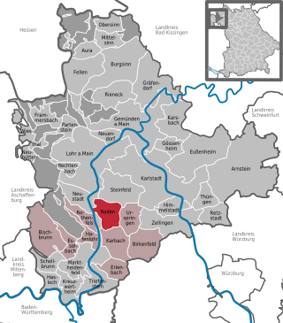
Roden is a community in the Main-Spessart district in the Regierungsbezirk of Lower Franconia (Unterfranken) in Bavaria, Germany and a member of the Verwaltungsgemeinschaft of Marktheidenfeld.

Steinfeld is a community in the Main-Spessart district in the Regierungsbezirk of Lower Franconia (Unterfranken) in Bavaria, Germany and a member of the Verwaltungsgemeinschaft of Lohr am Main.

The Ludwig Western Railway is a German railway line that was originally funded by the Kingdom of Bavaria. It runs from Bamberg via Würzburg to Aschaffenburg and on into the former "Kurhessian" Hanau.

The Würzburg–Aschaffenburg railway is an 89 kilometre-long railway line in the Bavarian province of Lower Franconia. It runs from Würzburg via Gemünden (Main) to Aschaffenburg. It is particularly important for long-distance and goods traffic because it links the Rhine-Main conurbation immediately northwest of Aschaffenburg with the Lower Franconian city of Würzburg and beyond it to the metropoles of Nuremberg and Munich. The German name derives from the fact that it initially runs parallel to the River Main and then cuts through the Spessart hills. It was opened on 22 June 1854 by the Frankfurt-Hanau Railway Company and is one of the oldest railways in Germany.

The Bundesstraße 26 or Federal Highway 26, runs between the city of Riedstadt at the B44, to the city of Hallstadt, at the Bundesautobahn 70, A70 in Germany. The highway run East to West. It crosses the River Main and the Mannheim–Frankfurt railway.