Burgsinn

Last updated
Burgsinn
DSCF0671.JPG
View from the Mäusberg over Burgsinn
Wappen Burgsinn.png
Location of Burgsinn within Main-Spessart district
Burgsinn in MSP.svg
Germany adm location map.svg
Red pog.svg
Burgsinn
Bavaria location map.svg
Red pog.svg
Burgsinn
Coordinates: 50°09′N09°39′E / 50.150°N 9.650°E / 50.150; 9.650 Coordinates: 50°09′N09°39′E / 50.150°N 9.650°E / 50.150; 9.650
Country Germany
State Bavaria
Admin. region Unterfranken
District Main-Spessart
Municipal assoc. Burgsinn
Government
   Mayor (202026) Robert Herold [1]
Area
  Total51.38 km2 (19.84 sq mi)
Elevation
190 m (620 ft)
Population
 (2020-12-31) [2]
  Total2,362
  Density46/km2 (120/sq mi)
Time zone UTC+01:00 (CET)
  Summer (DST) UTC+02:00 (CEST)
Postal codes
97775
Dialling codes 09356
Vehicle registration MSP
Website Municipal website

Burgsinn is a market community in the Main-Spessart district in the Regierungsbezirk of Lower Franconia (Unterfranken) in Bavaria, Germany and the seat of the Verwaltungsgemeinschaft (municipal association) of Burgsinn. It has a population of around 2,500.

Contents

Geography

Location

Burgsinn lies in the Main-Spessart district, in the Mittelgebirge Spessart. It is located in the valley of the river Sinn from which it takes its name.

Subdivisions

The community has only the Gemarkung (traditional rural cadastral area) of Burgsinn. The municipal territory stretches into the wooded hills east and west of the Sinn valley.

Neighbouring communities

Burgsinn borders on (from the north, clockwise): Mittelsinn, the unincorporated areas Forst Aura  [ de ] and Omerz und Roter Berg  [ de ], Wartmannsroth, Gräfendorf, Rieneck, Herrnwald  [ de ] (unincorporated area), Fellen and Aura im Sinngrund.

History

A stone hatchet found in Burgsinn, from the final days of the Neolithic Münchshöfener Kultur  [ de ] bears witness to the first known human presence in the municipal area.

In 812 a document from Fulda Abbey mentioned the Sinngau ("Sinn District"), or in the spelling of the time, Sinnahgeuue. From the year 1001 comes the first written proof of the community's existence; at that time it was the village of Sinna, a Würzburg holding. In 1303 a source speaks of Burgmannen of Gotzo, Aplo et Her (mannus) de Sinne occupying the Sinna border fortifications. In 1334, Emperor Ludwig der Bayer granted dem Dorf zu Synne ("The Village at Synne") everlasting market rights. In 1338, Dietz von Thüngen became hereditary Burgmann and lord of the castle and locality of Sinna. Dietz von Thüngen's son Wilhelm acquired the Burgsinn lordship, with all appurtenances, in 1405 for 10,000 Gulden

From 1405 until 1814 (with an interruption in the 17th century), Burgsinn was the seat of the Thüngen family (see House of Thüngen (German). [3] :63

The former knightly estate of the Barons of Thüngen was mediatized by Prince Primate von Dalberg's Principality of Aschaffenburg. In 1808, it was traded to the Grand Duchy of Würzburg, with which it passed to the Kingdom of Bavaria in 1814.

Demographics

Burgsinn

Economy

According to official statistics, there were 5 workers on the social welfare contribution rolls working in agriculture and forestry in 1998. In producing businesses this was 193, and in trade and transport 140. In other areas, 136 workers on the social welfare contribution rolls were employed, and 878 such workers worked from home. There were 3 processing businesses. Three businesses were in construction, and furthermore, in 1999, there were 24 agricultural operations with a working area of 371 ha, of which 29 ha was cropland and 325 ha was meadowland.

Municipal taxes in 1999 amounted to €1,065,000 (converted), of which net business taxes amounted to €155,000.

Governance

In 2014, Robert Herold (BüLi) was elected mayor with 58,4% of votes cast. [4]

Coat of arms

Voit von Rieneck family's coat of arms according to Siebmachers Wappenbuch Voit von Rieneck Siebmacher103 - Franken.jpg
Voit von Rieneck family's coat of arms according to Siebmachers Wappenbuch

The community's arms might be described thus: Or a ram's attire gules.

The ram's horn can have been taken from neither the arms borne by the Barons of Thüngen nor those borne by the Counts of Rieneck, even though both families are tightly bound with Burgsinn's history. While the half of Castle Burgsinn that the Counts of Rieneck held in fief passed, when the Counts’ Rothenfels line died out, back to Würzburg in 1333, with the Barons of Thüngen buying the whole castle in 1405 from Würzburg, it was the Voit von Rieneck family, long the Vögte at Rieneck, who were until the 15th century holders of part of the tithes and of the court at Mittelsinn.

In 1630, when the Electorate of Mainz moved to strip the family Thüngen of their fief, the court at Burgsinn was held by the von Rieneck family's steward. The Counts of Rieneck had already died out in the early 16th century. After the Thüngens were reinstated in Burgsinn in 1697, besides various other agreements made by the community, the community received an explicit assurance that it could use “its old village seal”. What kind of seal this was and from what time it came is not said, but since the Voit von Rieneck family bore a ram in its coat of arms, it can be assumed with a likelihood bordering on certainty that Burgsinn's coat of arms was a reduced version of the Voit von Rieneck family's.

Arts, culture and sightseeing

Monuments

Keep at the castle Burgsinn-MSP-029.JPG
Keep at the castle
Rienecker Tor (town gate) BurgsinnTor.JPG
Rienecker Tor (town gate)

There is also a park complex in the community and the cycle paths around Burgsinn run from Würzburg all the way to Fulda.

Infrastructure

Transport

Burgsinn lies on the Hanover-Würzburg high-speed rail line and the Flieden–Gemünden railway line. At the Betriebsbahnhof Burgsinn (depot), trains can be switched between the old and new lines.

The Staatsstrasse 2303 passes through Burgsinn. To the south it connects to Bundesstrasse 26 at Langenprozelten/Gemünden.

Health

Medical services are provided by three general practitioners with surgeries in the community, one dentist, a pharmacist and two physiotherapists. Furthermore, there is a Bavarian Red Cross rescue station in Burgsinn equipped with an ambulance.

Leisure

Burgsinn has at its disposal a relatively big outdoor swimming pool with a 50 m-long basin which includes a diving tower area (1, 2 and 3 m), a basin for non-swimmers with a slide and a wading pool. The complex also has a beach volleyball court.

Education

As of 1999 the following institutions existed in Burgsinn:

Related Research Articles

Spessart

Spessart is a Mittelgebirge, a range of low wooded mountains, in the States of Bavaria and Hesse in Germany. It is bordered by the Vogelsberg, Rhön and Odenwald. The highest elevation is the Geiersberg at 586 metres above sea level.

Rieneck Castle hilltop castle in Bavaria

Rieneck Castle is a hill castle located in the town of Rieneck, in Bavaria, southern Germany. It was built by Ludwig I, Count of Loon and Rieneck, around the year 1150. It is today used by the German Christian Guide and Scout Association.

Schönrain Priory

Schönrain Priory was a house of the Benedictine Order located near Lohr in the Spessart, in Bavaria in southern Germany. Few signs of the monastic buildings are visible today. The ruins that remain mostly consist of later additions when the structure served as a temporal dwelling and foresters' lodge.

Lohr am Main Place in Bavaria, Germany

Lohr am Main is a town in the Main-Spessart district in the Regierungsbezirk of Lower Franconia (Unterfranken) in Bavaria, Germany and the seat of the Verwaltungsgemeinschaft of Lohr am Main. It has a population of around 15,000.

Gemünden am Main Town in Bavaria, Germany

Gemünden am Main is a town in the Main-Spessart district in the Regierungsbezirk of Lower Franconia (Unterfranken) in Bavaria, Germany and lies roughly 40 km down the Main from Würzburg. Gemünden has around 10,000 inhabitants.

Rieneck Town in Bavaria, Germany

Rieneck is a town in the Main-Spessart district in the Regierungsbezirk of Lower Franconia (Unterfranken) in Bavaria, Germany.

Rothenfels Town in Bavaria, Germany

Rothenfels is a town in the Main-Spessart district in the Regierungsbezirk of Lower Franconia (Unterfranken) in Bavaria, Germany and a member of the Verwaltungsgemeinschaft of Marktheidenfeld. With a population of just around 1,000 it is said to be Bavaria’s smallest town.

Mespelbrunn Municipality in Bavaria, Germany

Mespelbrunn is a community in the Aschaffenburg district in the Regierungsbezirk of Lower Franconia (Unterfranken) in Bavaria, Germany and a member of the Verwaltungsgemeinschaft of Mespelbrunn, whose seat is in Heimbuchenthal.

Weibersbrunn Municipality in Bavaria, Germany

Weibersbrunn is a community with a population of close to 2,000 in the Aschaffenburg district in the Regierungsbezirk of Lower Franconia (Unterfranken) in Bavaria, Germany.

Aura im Sinngrund Municipality in Bavaria, Germany

Aura im Sinngrund is a community in the Main-Spessart district in the Regierungsbezirk of Lower Franconia (Unterfranken) in Bavaria, Germany and a member of the Verwaltungsgemeinschaft of Burgsinn.

Fellen Municipality in Bavaria, Germany

Fellen is a community in the Main-Spessart district in the Regierungsbezirk of Lower Franconia (Unterfranken) in Bavaria, Germany and a member of the Verwaltungsgemeinschaft of Burgsinn.

Mittelsinn Municipality in Bavaria, Germany

Mittelsinn is a community in the Main-Spessart district in the Regierungsbezirk of Lower Franconia (Unterfranken) in Bavaria, Germany and a member of the Verwaltungsgemeinschaft of Burgsinn.

Obersinn Municipality in Bavaria, Germany

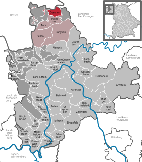
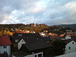
Obersinn is a market community in the Main-Spessart district in the Regierungsbezirk of Lower Franconia (Unterfranken) in Bavaria, Germany and a member of the Verwaltungsgemeinschaft of Burgsinn.

Thüngen Municipality in Bavaria, Germany

Thüngen is a market community in the Main-Spessart district in the Regierungsbezirk of Lower Franconia (Unterfranken) in Bavaria, Germany and a member of the Verwaltungsgemeinschaft of Zellingen.

Triefenstein Municipality in Bavaria, Germany

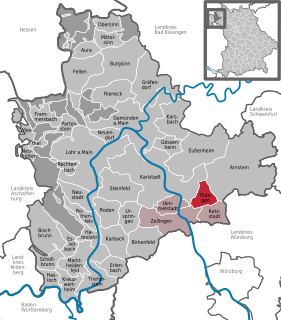
Markt Triefenstein is a market community in the Main-Spessart district in the Regierungsbezirk of Lower Franconia (Unterfranken) in Bavaria, Germany. It was created in 1978 out of the villages Homburg am Main, Lengfurt, Rettersheim and Trennfeld.

Urspringen Municipality in Bavaria, Germany

Urspringen is a community in the Main-Spessart district in the Regierungsbezirk of Lower Franconia (Unterfranken) in Bavaria, Germany and a member of the Verwaltungsgemeinschaft of Marktheidenfeld.

Jossgrund Municipality in Hesse, Germany

Jossgrund is a municipality in the Main-Kinzig district, in Hesse, Germany. It has around 3,500 inhabitants distributed among several formerly independent villages, now Ortsteile. The administration seat is at Oberndorf.

The County of Rieneck was a comital domain within the Holy Roman Empire that lay in what is now northwestern Bavaria. It bore the same name as its original ruling family, the Counts of Rieneck, from whom the county and its main seat, the town of Rieneck, got their names.

Sinn (river) River in Germany

The Sinn is a river that flows through the state of Hesse and the Bavarian province of Lower Franconia in southern Germany. It is about 69 kilometres (43 mi) long and is a right, northerly tributary of the Franconian Saale.

Scherenburg Castle

Scherenburg Castle is a ruined hill castle at an elevation of 200 m above sea level (NN) which stands on a hillside above the town of Gemünden am Main in the province of Lower Franconia in the German state of Bavaria.

References

  1. Liste der ersten Bürgermeister/Oberbürgermeister in kreisangehörigen Gemeinden, Bayerisches Landesamt für Statistik, 15 July 2021.
  2. "Tabellenblatt "Daten 2", Statistischer Bericht A1200C 202041 Einwohnerzahlen der Gemeinden, Kreise und Regierungsbezirke". Bayerisches Landesamt für Statistik (in German). June 2021.
  3. 1 2 Thiemig, Karl, ed. (1972). Grieben Reiseführer, Band 137: Spessart (German). Grieben Verlag, München.
  4. "Ergebnis der Bürgermeisterwahl 2014 im Markt Burgsinn (German)". Sinngrundallianz. Retrieved 8 April 2016.
  5. "Die Wasserburg (German)". Sinngrundallianz. Retrieved 8 April 2016.
  6. "Das Neue Schloss (German)". Sinngrundallianz. Retrieved 8 April 2016.
  7. "Das Fronhofer Schlösschen (German)". Sinngrundallianz. Retrieved 8 April 2016.
  8. "Das Rienecker Tor (German)". Sinngrundallianz. Retrieved 8 April 2016.
  9. "Die katholische Kirche (German)". Sinngrundallianz. Retrieved 8 April 2016.