Frammersbach

Last updated
Frammersbach
Frammersbach vom Backersberg.JPG
Frammersbach from Bäckersberg ("Baker's Hill")
Wappen von Frammersbach.svg
Location of Frammersbach within Main-Spessart district
Frammersbach in MSP.svgForst LohrerstraßeRuppertshüttener ForstRuppertshüttener ForstPartensteiner ForstPartensteiner ForstLangenprozeltener ForstHerrnwaldHaurainFürstlich Löwensteinscher ParkFrammersbacher ForstFrammersbacher ForstFrammersbacher ForstForst AuraForst AuraBurgjoß (unincorporated area)Burgjoß (unincorporated area)RodenNeuendorfKarbachBirkenfeldSteinfeld
Germany adm location map.svg
Red pog.svg
Frammersbach
Bavaria location map.svg
Red pog.svg
Frammersbach
Coordinates: 50°4′N9°28′E / 50.067°N 9.467°E / 50.067; 9.467
Country Germany
State Bavaria
Admin. region Lower Franconia
District Main-Spessart
Government
   Mayor (202228) Christian Holzemer [1] (SPD)
Area
  Total19.20 km2 (7.41 sq mi)
Elevation
246 m (807 ft)
Population
 (2022-12-31) [2]
  Total4,597
  Density240/km2 (620/sq mi)
Time zone UTC+01:00 (CET)
  Summer (DST) UTC+02:00 (CEST)
Postal codes
97833
Dialling codes 0 93 55
Vehicle registration MSP
Website www.frammersbach.de

Frammersbach is a market community in the Main-Spessart district in the Regierungsbezirk of Lower Franconia (Unterfranken) in Bavaria, Germany. In the early modern period, people from Frammersbach achieved international renown as drivers of wagons on the most important trans-European trade routes. Today, Frammersbach has a population of around 4,500.

Contents

Geography

Location

This state-recognized resort (staatlich anerkannter Erholungsort) lies between Würzburg und Aschaffenburg, in the middle of the Spessart Nature Park (Naturpark Spessart).

The municipal territory borders on the state of Hesse in places and is not continuous: Habichsthal is separated from Frammersbach proper by the wooded unincorporated area of the Frammersbacher Forst  [ de ]. On all other sides, the village is surrounded by the Heinrichsthaler Forst  [ de ] (located in the neighbouring Aschaffenburg district).

Frammersbach is located in the valley of the Lohr river, while Habichsthal lies in a side valley of the Aubach, which flows into the Lohr at Partenstein. Out of a total municipal area of around 2,000 hectares, about 700 hectares are covered by communally-owned forest. [3]

Nearby hills are the Wellersberg  [ de ], Eichenberg  [ de ] and the Hermannskoppe.

Subdivisions

The community has the following Gemarkungen (traditional rural cadastral areas): Frammersbach and Habichsthal. These are also Frammersbach's two Ortsteile (boroughs).

The former villages Herbertshain, Hofreith and Schwartel have been absorbed into Frammersbach proper.

Neighbouring communities

The neighbouring communities are from the north, clockwise: Flörsbachtal (Hesse), the unincorporated areas Haurain  [ de ] and Frammersbacher Forst, Partenstein, Partensteiner Forst  [ de ] (unincorporated area), Wiesthal, Heinrichsthaler Forst (unincorporated area), again Frammersbacher Forst and finally Wiesen.

History

There have been archaeological finds in the area dating to the Stone Age, the Bronze Age, and the Iron Age. [3]

The locality was systematically settled at the time when the Franks took the land. In around 500, a hunting outpost was established at the site of today's parish church. Through the 8th century, this was gradually expanded into a Zehnthof (tithe court) and fortified by an earthen rampart. Around 1000 a wall with five or six towers was constructed inside the rampart. The tithe court of Frammersbach belonged to the Catholic parish of Lohrhaupten (Flörsbachtal). [3] [4]

In 1314, Herbertshain is first mentioned in a surviving record. Until recently, the earliest mention of Frammersbach itself was thought to have been in 1339. However, new evidence suggests it was in fact also mentioned in 1314. [4] [5]

In 1553, Frammersbach converted to Protestantism under the Counts of Rieneck. After the family died out, Frammersbach fell to the Archbishop of Mainz in 1559. In 1605, the village reverted to Catholicism. [3] [4]

A window on village life is found in the Sechserbuch [6] – a book mainly about Frammersbach's Feldgeschworene, the traditional boundary keepers who decided where the community’s limits were and who were charged with marking them – which describes the state of affairs in a Spessart community in the waning years of the Middle Ages and the onset of the modern era, in particular the records of the decisions of the village court between 1572 and 1764.

In that early modern period — beginning in the 15th century — carters from Frammersbach dominated the long distance trade on two of the most important European routes: from Nuremberg to Antwerp and from Leipzig to Frankfurt (following the Via Regia). There were two reasons for the prominent role played by the people from this small town. For one, Frammersbach was well connected to the major trade routes by the Wiesener Strasse and then the Birkenhainer Strasse . Secondly, the Counts of Rieneck recognized the economic potential of the long distance trade and supported it. The carters built on these advantages by establishing an international acclaim for their performance. In 1522, two of them managed twice to cover 100 kilometres in a single day's travel, when the normal speed for carts was around 30 kilometres a day. [7]

During the Thirty Years' War, the village was sacked by Swedish troops and was temporarily completely depopulated in 1635. [3] The town was resettled, however, and in 1665 Frammersbach was granted the status of Markt. [4]

In 1803, with the Reichsdeputationshauptschluss , the former Amt of the Archbishopric of Mainz passed, along with the village, to Prince Primate Karl von Dalberg 's newly formed Principality of Aschaffenburg (1803–10), with which in 1814 it passed to the Kingdom of Bavaria under the terms of the Treaties of Paris, having previously been part of the Grand Duchy of Frankfurt (1810-4). [4]

In the 20th century, home tailoring became an important industry in Frammersbach, as did a clothing factory owned by Alfons Müller-Wipperfürth  [ de ].

In 1952, the community's official name was set to be Markt Frammersbach. [4] On 1 January 1975, Habichsthal was merged with Frammersbach. [8] At the same time, it was awarded the status of resort. [3]

Economy

The market community of Frammersbach has grown into a commercial centre and has regional supply functions for the community of Partenstein lying to the south and the community of Flörsbachtal lying to the north, just across the boundary in Hesse as well as the community of Jossgrund. The feeder area of the lesser centre of Frammersbach is home to roughly 18,500 inhabitants. Frammersbach lies on the Partenstein-Frammersbach-Wiesen-Aschaffenburg regional development axis.

Arts and culture

Culture

Churches

Parish church St. Bartholomaus Frammersbach, Kirche St. Bartholomaus.jpg
Parish church St. Bartholomäus

Sport and leisure facilities

Clubs

In Frammersbach 45 local clubs are currently active.

Customs and festivals

Government

Coat of arms

The community’s arms might be described thus: Per pale argent a waggoner vert and gules in chief a wheel of the first spoked of six and in base three closets Or.

The wheel is the Wheel of Mainz, and the closets (that is, narrow horizontal bars) are drawn from the arms borne by the Counts of Rieneck, which themselves go back to those borne by the Counts of Loon.

Twin towns – sister cities

The latter place is home to descendants of emigrants from Frammersbach who still speak a dialect of German rather like the one spoken in Frammersbach. [12]

This is a sponsorship arrangement initiated on 14 May 1977 by former citizens from St. Joachimsthal's (now called Jáchymov) outlying centre of Dürnberg (now called Suchá) who after being driven out of their old homeland came to live in Frammersbach. Both regions were protected forests (Bannwälder) where one could settle only on the edges. In both areas was an Eselsweg (“ass’s way”) and in each was a village with a greater than average number of people working in goods transport, Frammersbach in the Spessart and Reischdorf (now called Rusová) in the Ore Mountains.

Infrastructure

Transport

Through Frammersbach run Bundesstraße 276  [ de ], going north-south, and Staatsstraße (State Road) 2305, going east-west.

The nearest Autobahn interchanges are:

Frammersbach is linked to local transport on weekdays through the following bus routes:

Frammersbach has no direct link to the DB railway network. The nearest railway station is at Partenstein, 5 km away. Railway goods transport is handled through the station at Lohr am Main, 13 km away. Both stations lie on DB’s Nuremberg-Frankfurt mainline.

The nearest airport is Frankfurt Airport, which can be reached on the A 3 or the A 66. The distance is about 80 km, while Nuremberg Airport lies roughly 160 km away.

Education

Schools

Kindergartens

Youth work

Notable people

Related Research Articles

<span class="mw-page-title-main">Schöllkrippen</span> Municipality in Bavaria, Germany

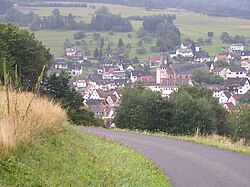
Schöllkrippen is a market community in the Aschaffenburg district in the Regierungsbezirk of Lower Franconia (Unterfranken) in Bavaria, Germany and seat of the Verwaltungsgemeinschaft of Schöllkrippen. It has a total population of around 4,300 (2020).

<span class="mw-page-title-main">Neuendorf, Bavaria</span> Municipality in Bavaria, Germany

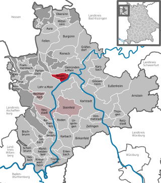
Neuendorf is a community in the Main-Spessart district in the Regierungsbezirk of Lower Franconia (Unterfranken) in Bavaria, Germany and a member of the Verwaltungsgemeinschaft of Lohr am Main.

<span class="mw-page-title-main">Lohr am Main</span> Place in Bavaria, Germany

Lohr am Main is a town in the Main-Spessart district in the Regierungsbezirk of Lower Franconia (Unterfranken) in Bavaria, Germany and the seat of the Verwaltungsgemeinschaft of Lohr am Main. It has a population of around 15,000.

<span class="mw-page-title-main">Rieneck</span> Town in Bavaria, Germany

Rieneck is a town in the Main-Spessart district in the Regierungsbezirk of Lower Franconia (Unterfranken) in Bavaria, Germany.

<span class="mw-page-title-main">Laufach</span> Municipality in Bavaria, Germany

Laufach is a community in the Aschaffenburg district in the Regierungsbezirk of Lower Franconia (Unterfranken) in Bavaria, Germany.

<span class="mw-page-title-main">Mespelbrunn</span> Municipality in Bavaria, Germany

Mespelbrunn is a community in the Aschaffenburg district in the Regierungsbezirk of Lower Franconia (Unterfranken) in Bavaria, Germany and a member of the Verwaltungsgemeinschaft of Mespelbrunn, whose seat is in Heimbuchenthal.

<span class="mw-page-title-main">Sailauf</span> Municipality in Bavaria, Germany

Sailauf is a municipality in the Aschaffenburg district in the Regierungsbezirk of Lower Franconia (Unterfranken) in Bavaria, Germany. It has a population of around 3,600.

<span class="mw-page-title-main">Weibersbrunn</span> Municipality in Bavaria, Germany

Weibersbrunn is a community with a population of close to 2,000 in the Aschaffenburg district in the Regierungsbezirk of Lower Franconia (Unterfranken) in Bavaria, Germany.

<span class="mw-page-title-main">Burgsinn</span> Municipality in Bavaria, Germany

Burgsinn is a market community in the Main-Spessart district in the Regierungsbezirk of Lower Franconia (Unterfranken) in Bavaria, Germany and the seat of the Verwaltungsgemeinschaft of Burgsinn. It has a population of around 2,500.

<span class="mw-page-title-main">Neuhütten</span> Municipality in Bavaria, Germany

Neuhütten is a community in the Main-Spessart district in the Regierungsbezirk of Lower Franconia (Unterfranken) in Bavaria, Germany and a member of the Verwaltungsgemeinschaft of Partenstein. It has a population of around 1,100.

<span class="mw-page-title-main">Neustadt am Main</span> Municipality in Bavaria, Germany

Neustadt am Main is a community in the Main-Spessart district in the Regierungsbezirk of Lower Franconia (Unterfranken) in Bavaria, Germany and a member of the Verwaltungsgemeinschaft Lohr am Main.

<span class="mw-page-title-main">Partenstein</span> Municipality in Bavaria, Germany

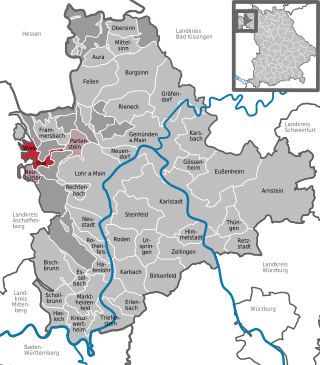
Partenstein is a community in the Main-Spessart district in the Regierungsbezirk of Lower Franconia (Unterfranken) in Bavaria, Germany and the seat of the Verwaltungsgemeinschaft of Partenstein. Partenstein is located on Bundesstraße 276.

<span class="mw-page-title-main">Rechtenbach</span> Municipality in Bavaria, Germany

Rechtenbach is a community in the Main-Spessart district in the Regierungsbezirk of Lower Franconia (Unterfranken) in Bavaria, Germany and a member of the Verwaltungsgemeinschaft of Lohr am Main. It has a population of around 1,000.

<span class="mw-page-title-main">Wiesthal</span> Municipality in Bavaria, Germany

Wiesthal is a community in the Main-Spessart district in the Regierungsbezirk of Lower Franconia (Unterfranken) in Bavaria, Germany and a member of the Verwaltungsgemeinschaft of Partenstein. It has a population of around 1,300.

<span class="mw-page-title-main">Wheel of Mainz</span>

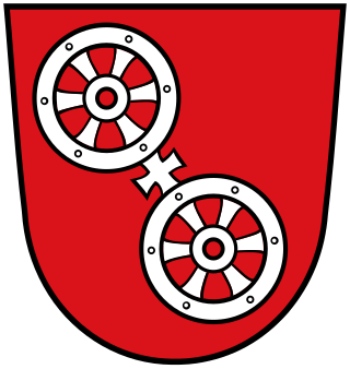
The Wheel of Mainz or Mainzer Rad, in German, was the coat of arms of the Archbishopric of Mainz and thus also of the Electorate of Mainz (Kurmainz), in Rhineland-Palatinate, Germany. It consists of a silver wheel with six spokes on a red background. The wheel can also be found in stonemasons' carvings and similar objects. Currently, the City of Mainz uses a double wheel connected by a silver cross.

<span class="mw-page-title-main">Biebergemünd</span> Municipality in Hesse, Germany

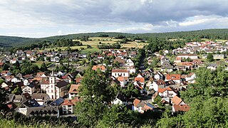
Biebergemünd is a municipality in the Main-Kinzig district, in Hesse, Germany. It has a population of over 8,000 and lies in the wooded hills of the Spessart.

<span class="mw-page-title-main">Flörsbachtal</span> Municipality in Hesse, Germany

Flörsbachtal is a municipality in the Main-Kinzig district, in Hesse, Germany. It has a population close to 2,400. Flösbachtal contains both the oldest parish and the youngest settlement established in the Spessart hills. Located within the municipal territory is the Hermannskoppe, the highest elevation in the Hessian part of the Spessart and the Wiesbüttmoor, a rare hanging bog.

<span class="mw-page-title-main">Jossgrund</span> Municipality in Hesse, Germany

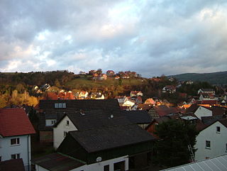
Jossgrund is a municipality in the Main-Kinzig district, in Hesse, Germany. It has around 3,500 inhabitants distributed among several formerly independent villages, now Ortsteile. The administration seat is at Oberndorf.

<span class="mw-page-title-main">Würzburg–Aschaffenburg railway</span>

The Würzburg–Aschaffenburg railway is an 89 kilometre-long railway line in the Bavarian province of Lower Franconia. It runs from Würzburg via Gemünden (Main) to Aschaffenburg. It is particularly important for long-distance and goods traffic because it links the Rhine-Main conurbation immediately northwest of Aschaffenburg with the Lower Franconian city of Würzburg and beyond it to the metropoles of Nuremberg and Munich. The German name derives from the fact that it initially runs parallel to the River Main and then cuts through the Spessart hills. It was opened on 22 June 1854 by the Frankfurt-Hanau Railway Company and is one of the oldest railways in Germany.

<span class="mw-page-title-main">Birkenhainer Straße</span>

The Birkenhainer Straße is a long-distance hiking trail that follows an ancient trade route through the Mittelgebirge Spessart, in the states of Hesse and Bavaria, Germany. It is 71 km long and leads from Hanau to Gemünden am Main, cutting across the so-called Mainviereck, a large loop of the river Main. The trail follows an ancient trade route which in the Middle Ages was an important road for moving troops and for long-distance trade. The Birkenhainer Straße was a part of the link between Nuremberg and Antwerp. Its origins may lie back as far as the Neolithic period. The name likely derives from a prominent copse of birch trees that used to exist near the road at Geiselbach (Hesse).

References

  1. Liste der ersten Bürgermeister/Oberbürgermeister in kreisangehörigen Gemeinden, Bayerisches Landesamt für Statistik. Retrieved 5 September 2023.
  2. Genesis Online-Datenbank des Bayerischen Landesamtes für Statistik Tabelle 12411-003r Fortschreibung des Bevölkerungsstandes: Gemeinden, Stichtag (Einwohnerzahlen auf Grundlage des Zensus 2011)
  3. 1 2 3 4 5 6 "Ortsgeschichte (German)". Gemeinde Markt Frammersbach. Retrieved 2 September 2015.
  4. 1 2 3 4 5 6 7 "Flyer Historischer Rundgang (German)" (PDF). Museumsverein des Markt Frammersbach. Retrieved 2 September 2015.
  5. Helfmann, Annette (23 April 2014). "Überraschung: Frammersbach wird heuer 700(German)". Main-Echo. Retrieved 2 September 2015.
  6. "Sechserbuch". Archived from the original on 2014-11-25. Retrieved 2009-03-26.
  7. "European Culture Trail - Hohlwege (German, English summary)". Europäisches Koordinationsbüro Pathways to Cultural Landscapes. Retrieved 4 July 2014.
  8. Historisches Gemeindeverzeichnis für die Bundesrepublik Deutschland. Namens-, Grenz- und Schlüsselnummernänderungen bei Gemeinden, Kreisen und Regierungsbezirken vom 27. 5. 1970 bis 31. 12. 1982. Statistisches Bundesamt. 1983. p. 762. ISBN   3-17-003263-1.
  9. 1 2 "Die Kreuzkapelle (German)". Archäologisches Spessartprojekt e.V. Retrieved 2 September 2015.
  10. "Pfarrkirche St Thekla (German)". Gemeinde Markt Frammersbach. Retrieved 2 September 2015.
  11. "Evangelische Friedenskirche (German)". Gemeinde Markt Frammersbach. Retrieved 2 September 2015.
  12. Nähere Informationen Städtepartnerschaft Nadasch
  13. "Herzlich Willkommen".