Karlstadt am Main

Last updated
Karlstadt am Main
Karlstadt von der Karlsburg.JPG
Old town of Karlstadt with the new building area at the Saupurzel in the background
Wappen Karlstadt.svg
Location of Karlstadt am Main within Main-Spessart district
Karlstadt in MSP.svgForst LohrerstraßeRuppertshüttener ForstRuppertshüttener ForstPartensteiner ForstPartensteiner ForstLangenprozeltener ForstHerrnwaldHaurainFürstlich Löwensteinscher ParkFrammersbacher ForstFrammersbacher ForstFrammersbacher ForstForst AuraForst AuraBurgjoß (unincorporated area)Burgjoß (unincorporated area)RodenNeuendorfKarbachBirkenfeldSteinfeld
Germany adm location map.svg
Red pog.svg
Karlstadt am Main
Bavaria location map.svg
Red pog.svg
Karlstadt am Main
Coordinates: 49°57′37″N9°46′20″E / 49.96028°N 9.77222°E / 49.96028; 9.77222
Country Germany
State Bavaria
Admin. region Unterfranken
District Main-Spessart
Subdivisions10 Ortsteile
Government
   Mayor (202026) Michael Hombach [1] (CSU)
Area
  Total98.11 km2 (37.88 sq mi)
Elevation
163 m (535 ft)
Population
 (2022-12-31) [2]
  Total14,995
  Density150/km2 (400/sq mi)
Time zone UTC+01:00 (CET)
  Summer (DST) UTC+02:00 (CEST)
Postal codes
97753
Dialling codes 09353, 09359 (Rohrbach)
Vehicle registration MSP
Website www.karlstadt.de

Karlstadt is a town in the Main-Spessart in the Regierungsbezirk of Lower Franconia (Unterfranken) in Bavaria, Germany. It is the administrative centre of Main-Spessart (Kreisstadt), and has a population of around 15,000.

Contents

Geography

Karlstadt lies on the River Main in the district (Landkreis) of Main-Spessart, roughly 25 km north of the city of Würzburg. It belongs to the Main-Franconian wine-growing region. The town itself is located on the right bank of the river, but the municipal territory extends to the left bank.

Since the amalgamations in 1978, Karlstadt's Stadtteile have been Gambach, Heßlar, Karlburg, Karlstadt, Laudenbach, Mühlbach, Rohrbach, Stadelhofen, Stetten, and Wiesenfeld.

History

From the late 6th to the mid-13th century, the settlement of Karlburg with its monastery and harbor was located on the west bank of the Main. It grew up around the Karlsburg, a castle perched high over the community, that was destroyed in the German Peasants' War in 1525.

In 1202, Karlstadt itself was founded by Konrad von Querfurt, Bishop of Würzburg. The town was methodically laid out with a nearly rectangular plan to defend Würzburg territory against the Counts of Rieneck. The plan is still well preserved today. The streets in the old town are laid out much like a chessboard, but for military reasons they are not quite straight.

In 1225, Karlstadt had its first documentary mention. In 1236, the castle and the village of Karlburg were destroyed in the Rieneck Feud. In 1244, winegrowing in Karlstadt was mentioned for the first time. From 1277 comes the earliest evidence of the town seal. In 1304, the town fortifications were finished. The parish of Karlstadt was first named in 1339. In 1369 a hospital was founded. Between 1370 and 1515, remodelling work was being done on the first, Romanesque parish church to turn it into a Gothic hall church. About 1400, Karlstadt became for a short time the seat of an episcopal mint. The former Oberamt of the Princely Electorate (Hochstift) of Würzburg was, after Secularization, in Bavaria's favour, passed in 1805 to Grand Duke Ferdinando III of Tuscany to form the Grand Duchy of Würzburg, and passed with this to the Kingdom of Bavaria.

The Jewish residents of the town had a synagogue as early as the Middle Ages. [3] The town's synagogue was destroyed on Kristallnacht (the Night of Broken Glass, 9 November 1938) by Nazi SA men, SS, and Hitler Youth, as well as other local residents. [3] Its destruction is recalled by a plaque at the synagogue's former site. [4] The homes of Jewish residents were attacked as well, the possessions therein were looted or brought to the square in front of the town hall where they were burned, and the Jews living in the town were beaten. [3]

Governance

The mayor of Karlstadt is Michael Hombach (CSU), elected in 2020. [1]

The council is made up of 24 council members, excluding the mayor.

CSU SPD Grüne FWG Total
20021072524 seats
2008863724 seats

(as of 2 March 2008)

The town's coat of arms might be described thus: Quarterly, first and fourth azure, second and third argent a fleur-de-lis gules. The town's earliest seal, from 1277, showed an effigy of Charlemagne, who is said to have founded and named the town (Charlemagne is called Karl der Große in German). The next seal after this one also bore Charlemagne's likeness, and this appeared on town seals until the 18th century. However, in 1544 the town began using a quartered shield as its arms. This is thought to have come from the banner of state borne by the Prince-Bishopric (Hochstift) of Würzburg, to which the town once belonged. The fleurs-de-lis were added in the early 19th century, and they refer to Charlemagne. [5]

Transport

Economy

Industry south of Karlstadt. 2013-09-19 Karlstadt economy 50519.jpg
Industry south of Karlstadt.

Local industry includes Düker Ironworks, the Schwenk Cement Works, and the Kohl Wood Veneer Factory. Besides these three large industrial plants, many handicraft businesses have also set up shop in Karlstadt. Another big employer is the Main-Spessart Landratsamt (district administration). Many inhabitants commute to Würzburg, 25 km away, or Lohr am Main, 18 km away.

Winegrowing has only a small economic importance nowadays, but still has great cultural significance. Vineyards in Karlstadt are the Roßtal and Im Stein. There are also others in centres, especially in Stetten (Stettener Stein) and on the way from the main town out to Gambach.

Education

In 1999 the following institutions existed in Karlstadt:

Notable people

Johannes Schoner Portrait-of-magdeburg-theologians-dr-johannes-schoner-1529.jpg
Johannes Schöner
Ruth Westheimer RuthWestheimer-a.jpg
Ruth Westheimer

Related Research Articles

Main-Spessart is a Landkreis (district) in the northwest of Bavaria, Germany. It is located in Lower Franconia and derives its name from the river Main and the wooded hills of the Spessart.

Würzburg is a Landkreis (district) in the northwestern part of Bavaria, Germany. Neighboring districts are Main-Spessart, Schweinfurt, Kitzingen, Neustadt (Aisch)-Bad Windsheim, and the district Main-Tauber in Baden-Württemberg. The city Würzburg is not part of the district, although it is completely enclosed by it.

<span class="mw-page-title-main">Lohr am Main</span> Place in Bavaria, Germany

Lohr am Main is a town in the Main-Spessart district in the Regierungsbezirk of Lower Franconia (Unterfranken) in Bavaria, Germany and the seat of the Verwaltungsgemeinschaft of Lohr am Main. It has a population of around 15,000.

<span class="mw-page-title-main">Gemünden am Main</span> Town in Bavaria, Germany

Gemünden am Main is a town in the Main-Spessart district in the Regierungsbezirk of Lower Franconia (Unterfranken) in Bavaria, Germany and lies roughly 40 km down the Main from Würzburg. Gemünden has around 10,000 inhabitants.

<span class="mw-page-title-main">Rieneck</span> Town in Bavaria, Germany

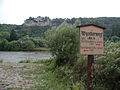
Rieneck is a town in the Main-Spessart district in the Regierungsbezirk of Lower Franconia (Unterfranken) in Bavaria, Germany.

<span class="mw-page-title-main">Rothenfels</span> Town in Bavaria, Germany

Rothenfels is a town in the Main-Spessart district in the Regierungsbezirk of Lower Franconia (Unterfranken) in Bavaria, Germany and a member of the Verwaltungsgemeinschaft of Marktheidenfeld. With a population of just around 1,000 it is said to be Bavaria’s smallest town.

<span class="mw-page-title-main">Bischbrunn</span> Municipality in Bavaria, Germany

Bischbrunn is a community with around 1,800 (2013) inhabitants in the Main-Spessart district in the Regierungsbezirk of Lower Franconia (Unterfranken) in Bavaria, Germany and a member of the Verwaltungsgemeinschaft of Marktheidenfeld.

<span class="mw-page-title-main">Burgsinn</span> Municipality in Bavaria, Germany

Burgsinn is a market community in the Main-Spessart district in the Regierungsbezirk of Lower Franconia (Unterfranken) in Bavaria, Germany and the seat of the Verwaltungsgemeinschaft of Burgsinn. It has a population of around 2,500.

<span class="mw-page-title-main">Gössenheim</span> Municipality in Bavaria, Germany

Gössenheim is a community in the Main-Spessart district in the Regierungsbezirk of Lower Franconia (Unterfranken) in Bavaria, Germany and a member of the Verwaltungsgemeinschaft of Gemünden am Main.

<span class="mw-page-title-main">Hafenlohr</span> Municipality in Bavaria, Germany

Hafenlohr is a community in the Main-Spessart district in the Regierungsbezirk of Lower Franconia (Unterfranken) in Bavaria, Germany and a member of the Verwaltungsgemeinschaft of Marktheidenfeld.

<span class="mw-page-title-main">Mittelsinn</span> Municipality in Bavaria, Germany

Mittelsinn is a municipality in the Main-Spessart district in the Regierungsbezirk of Lower Franconia (Unterfranken) in Bavaria, Germany and a member of the Verwaltungsgemeinschaft of Burgsinn.

<span class="mw-page-title-main">Neustadt am Main</span> Municipality in Bavaria, Germany

Neustadt am Main is a community in the Main-Spessart district in the Regierungsbezirk of Lower Franconia (Unterfranken) in Bavaria, Germany and a member of the Verwaltungsgemeinschaft Lohr am Main.

<span class="mw-page-title-main">Rechtenbach</span> Municipality in Bavaria, Germany

Rechtenbach is a community in the Main-Spessart district in the Regierungsbezirk of Lower Franconia (Unterfranken) in Bavaria, Germany and a member of the Verwaltungsgemeinschaft of Lohr am Main. It has a population of around 1,000.

<span class="mw-page-title-main">Retzstadt</span> Municipality in Bavaria, Germany

Retzstadt is a community in the Main-Spessart district in the Regierungsbezirk of Lower Franconia (Unterfranken) in Bavaria, Germany and a member of the Verwaltungsgemeinschaft of Zellingen.

<span class="mw-page-title-main">Steinfeld, Bavaria</span> Municipality in Bavaria, Germany

Steinfeld is a community in the Main-Spessart district in the Regierungsbezirk of Lower Franconia (Unterfranken) in Bavaria, Germany and a member of the Verwaltungsgemeinschaft of Lohr am Main.

<span class="mw-page-title-main">Triefenstein</span> Municipality in Bavaria, Germany

Markt Triefenstein is a market community in the Main-Spessart district in the Regierungsbezirk of Lower Franconia (Unterfranken) in Bavaria, Germany. It was created in 1978 out of the villages Homburg am Main, Lengfurt, Rettersheim and Trennfeld.

<span class="mw-page-title-main">Urspringen</span> Municipality in Bavaria, Germany

Urspringen is a community in the Main-Spessart district in the Regierungsbezirk of Lower Franconia (Unterfranken) in Bavaria, Germany and a member of the Verwaltungsgemeinschaft of Marktheidenfeld.

<span class="mw-page-title-main">Kleinheubach</span> Municipality in Bavaria, Germany

Kleinheubach is a market community in the Miltenberg district in the Regierungsbezirk of Lower Franconia (Unterfranken) in Bavaria, Germany and the seat of the like-named Verwaltungsgemeinschaft. As of the 2011 census, it has a population of around 3,614.

<span class="mw-page-title-main">Erlenbach bei Marktheidenfeld</span> Municipality in Bavaria, Germany

Erlenbach bei Marktheidenfeld is a community in the Main-Spessart district in the Regierungsbezirk of Lower Franconia in Bavaria, Germany and a member of the Verwaltungsgemeinschaft of Marktheidenfeld. It has given itself the title Weinort mit Herz – Wine Town with Heart.

Laudenbach is a village in the Main-Spessart district of Lower Franconia, Bavaria, Germany, which belongs to the town of Karlstadt am Main. Laudenbach is situated opposite Karlstadt, on the left bank of the Main, but was incorporated into the town administratively in 1978. The postcode is 97753.

References

  1. 1 2 Liste der ersten Bürgermeister/Oberbürgermeister in kreisangehörigen Gemeinden, Bayerisches Landesamt für Statistik, 15 July 2021.
  2. Genesis Online-Datenbank des Bayerischen Landesamtes für Statistik Tabelle 12411-003r Fortschreibung des Bevölkerungsstandes: Gemeinden, Stichtag (Einwohnerzahlen auf Grundlage des Zensus 2011)
  3. 1 2 3 "Die Synagoge in Karlstadt (Main-Spessart-Kreis)". www.alemannia-judaica.de. Retrieved 2023-07-14.
  4. Gedenkstätten für die Opfer des Nationalsozialismus. Eine Dokumentation, Band 1. Bundeszentrale für politische Bildung, Bonn 1995, ISBN   3-89331-208-0, S. 152
  5. "Town's armorial history at Heraldry of the World".