Rothenfels

Last updated
Rothenfels
Rothenfels, MSP v NO.jpg
Rothenfels from the northeast across the Main, Rothenfels Castle in the background
DEU Rothenfels COA.svg
Location of Rothenfels within Main-Spessart district
Rothenfels in MSP.svgForst LohrerstraßeRuppertshüttener ForstRuppertshüttener ForstPartensteiner ForstPartensteiner ForstLangenprozeltener ForstHerrnwaldHaurainFürstlich Löwensteinscher ParkFrammersbacher ForstFrammersbacher ForstFrammersbacher ForstForst AuraForst AuraBurgjoß (unincorporated area)Burgjoß (unincorporated area)RodenNeuendorfKarbachBirkenfeldSteinfeld
Germany adm location map.svg
Red pog.svg
Rothenfels
Bavaria location map.svg
Red pog.svg
Rothenfels
Coordinates: 49°53′N9°35′E / 49.883°N 9.583°E / 49.883; 9.583
Country Germany
State Bavaria
Admin. region Unterfranken
District Main-Spessart
Municipal assoc. Marktheidenfeld
Government
   Mayor (202026) Michael Gram [1]
Area
  Total
12.07 km2 (4.66 sq mi)
Elevation
154 m (505 ft)
Population
 (2023-12-31) [2]
  Total
1,022
  Density85/km2 (220/sq mi)
Time zone UTC+01:00 (CET)
  Summer (DST) UTC+02:00 (CEST)
Postal codes
97851
Dialling codes 09393
Vehicle registration MSP
Website www.rothenfels.de

Rothenfels is a town in the Main-Spessart district in the Regierungsbezirk of Lower Franconia (Unterfranken) in Bavaria, Germany, and a member of the Verwaltungsgemeinschaft (municipal association) of Marktheidenfeld. With a population of just around 1,000, it is said to be Bavaria's smallest town.

Contents

Geography

Location

Rothenfels lies on the Main's right bank between Lohr and Marktheidenfeld, 5 km north of Marktheidenfeld, and 33 km east of Aschaffenburg. Squeezed as it is between the river and a bluff, the town consists of little more than a main street. Since 2006, the Maindamm, previously part of the railway line Lohr-Wertheim  [ de ] has been used as a town bypass.

Neighbouring communities

From the north, clockwise: Neustadt am Main, Marktheidenfeld, Hafenlohr, Fürstlich Löwensteinscher Park  [ de ] (gemeindefreies Gebiet).

Subdivisions

Rothenfels has two Stadtteile , Rothenfels in the valley of the Main and Bergrothenfels on the hill, next to Rothenfels Castle ( Burg Rothenfels  [ de ]).

History

Marquardt II von Grumbach, Vogt of Neustadt Abbey, built a "hunting lodge" on the hill where the castle stands today. However, the land was property of the abbey, and the neighbours felt threatened by the fortification. The king asked the Prince-Bishop of Würzburg to settle the conflict. As a result of his mediation, Marquardt received the land as a fief in 1150, but he had to pay an annual rent to the abbey. Around 1200 the castle was rebuilt, and the bergfried was made from large bunter blocks on a square plan. Construction of the new castle wall also started with large blocks but was finished with quarrystone. [3] :40

Rothenfels Castle, with bunter bergfried and wall Burg Rothenfels02 2011-08-10.jpg
Rothenfels Castle, with bunter bergfried and wall

The settlements, which arose under Rothenfels Castle's protection, were the later town in the valley and the farming estate that later became Bergrothenfels. When, in 1243, Albert II, the last of the Gumbach family died, town and castle came to the Counts of Rieneck. Ludwig III of Rieneck had married Albert's daughter. However, a document from 1150 stated that the castle should return to Neustadt Abbey in such a case. The abbey was not able to enforce its claim, Würzburg offered no support but rather helped to appoint the Count of Rieneck as vogt of Neustadt Abbey. Thus the County added a southern property to its northern possessions around Rieneck and Lohr. In 1333, Count Ludwig V of Rieneck-Rothenfels died and an inheritance dispute ensued. After prolonged legal fighting, the Counts lost their territory to the Archbishopric of Mainz, the Prince-Bishop of Würzburg and the Lords of Hanau. Rothenfels came to Würzburg. A document from 1342 refers to Rothenfels as a town. [3] :40

In the 16th and early 17th century Rothenfels faced hardships, e.g. during the German Peasants War (1525) when the insurgents occupied and burned the castle. In the second half of the 16th century the town prospered based on shipping, fishing, trade and local crafts. This is the era in which the representative dwellings still extant were constructed in the town (see below). Around 1600 Rothenfels was the site of witch hunts in which around 100 women and men were charged with witchcraft, tortured and often killed. The Thirty Years' War brought another period of destruction: the castle was repeatedly occupied by passing armies and sacked. The population declined due to famine and plague. [3] :41

During German Mediatisation in the early 19th century, the Prince-Bishopric became the Grand Duchy of Würzburg. Castle and Amt Rothenfels passed to the princely house of Löwenstein-Wertheim-Rosenberg in 1803, and then in 1806 to the Principality of Aschaffenburg; in 1813, Rothenfels became part of the Kingdom of Bavaria. The castle remained property of the Lowenstein family. [3] :41

In 1881, the Lohr–Wertheim line was opened, connecting the town to the railway system. [3] :41

After World War II many Vertriebene came to the area, but Rothenfels remained the smallest municipality with town rights in Bavaria. [3] :40–1

Bergrothenfels was separated administratively from Rothenfels in the 19th century, only to be reamalgamated in the 1971 Gebietsreform. [3] :41

Governance

Mayor

From 1996 to 2014 Rosemarie Richartz (Stadtrat 96) was the mayor of Rothenfels. Since 2014 Michael Gram (Unabhängige Bürger/Freie Bürger/SPD) is the new mayor. [4]

Coat of arms

The town's arms might be described thus: Or in base water argent, issuant therefrom three crags gules, in chief the letter R of the same.

The town's oldest known seal, carved in the late 16th century and known from a 1619 imprint, only showed the uppercase R. The same image is shown in a roll of arms from 1544, wherein the R is shown in red on a silver field. Shown on town and council seals from 1710 is a castle on crags, which are surmounted by the uppercase R (that is, the R is on the crags, not over them), possibly canting for the town's name, which means "Stronghold in Red Bunter". Since the early 19th century, all examples of the town's seal show the current composition. The arms were affirmed in 1836. [5]

Attractions

Aside from its late-16th century town hall  [ de ] and the former Spital (1578-97), the town features some historic timber-frame houses from the 16th and 17th centuries. [3] :40

The parish church was originally built in the 15th century, serving both Rothenfels and Bergrothenfels. It was renovated in 1610/1. The Baroque tower dates from 1750. [3] :40

On the hill above the town stands Rothenfels Castle (Burg Rothenfels). Rothenfels Castle is associated with the Catholic youth movement "Quickborn  [ de ]" (named after Quickborn in Schleswig-Holstein), and serves as a Christian education and conference centre. The castle is also a German Youth Hostel Association (DJH) youth hostel.

Related Research Articles

<span class="mw-page-title-main">Spessart</span> Mountain range in Germany

Spessart is a Mittelgebirge, a range of low wooded mountains, in the States of Bavaria and Hesse in Germany. It is bordered by the Vogelsberg, Rhön and Odenwald. The highest elevation is the Geiersberg at 586 metres above sea level.

Main-Spessart is a Landkreis (district) in the northwest of Bavaria, Germany. It is located in Lower Franconia and derives its name from the river Main and the wooded hills of the Spessart.

<span class="mw-page-title-main">Neuendorf, Bavaria</span> Municipality in Bavaria, Germany

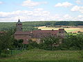
Neuendorf is a community in the Main-Spessart district in the Regierungsbezirk of Lower Franconia (Unterfranken) in Bavaria, Germany and a member of the Verwaltungsgemeinschaft of Lohr am Main.

<span class="mw-page-title-main">Lohr am Main</span> Place in Bavaria, Germany

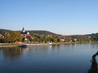
Lohr am Main is a town in the Main-Spessart district in the Regierungsbezirk of Lower Franconia (Unterfranken) in Bavaria, Germany and the seat of the Verwaltungsgemeinschaft of Lohr am Main. It has a population of around 15,000.

<span class="mw-page-title-main">Marktheidenfeld</span> Town in Bavaria, Germany

Marktheidenfeld is a town in the Main-Spessart district in the Regierungsbezirk of Lower Franconia (Unterfranken) in Bavaria, Germany, and the seat of the Verwaltungsgemeinschaft of Marktheidenfeld. The town has around 11,000 inhabitants.

<span class="mw-page-title-main">Rieneck</span> Town in Bavaria, Germany

Rieneck is a town in the Main-Spessart district in the Regierungsbezirk of Lower Franconia (Unterfranken) in Bavaria, Germany.

<span class="mw-page-title-main">Mespelbrunn</span> Municipality in Bavaria, Germany

Mespelbrunn is a community in the Aschaffenburg district in the Regierungsbezirk of Lower Franconia (Unterfranken) in Bavaria, Germany and a member of the Verwaltungsgemeinschaft of Mespelbrunn, whose seat is in Heimbuchenthal.

<span class="mw-page-title-main">Weibersbrunn</span> Municipality in Bavaria, Germany

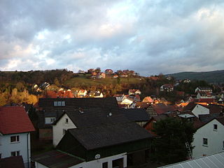
Weibersbrunn is a community with a population of close to 2,000 in the Aschaffenburg district in the Regierungsbezirk of Lower Franconia (Unterfranken) in Bavaria, Germany.

<span class="mw-page-title-main">Burgsinn</span> Municipality in Bavaria, Germany

Burgsinn is a market community in the Main-Spessart district in the Regierungsbezirk of Lower Franconia (Unterfranken) in Bavaria, Germany and the seat of the Verwaltungsgemeinschaft of Burgsinn. It has a population of around 2,500.

<span class="mw-page-title-main">Hafenlohr</span> Municipality in Bavaria, Germany

Hafenlohr is a community in the Main-Spessart district in the Regierungsbezirk of Lower Franconia (Unterfranken) in Bavaria, Germany and a member of the Verwaltungsgemeinschaft of Marktheidenfeld.

<span class="mw-page-title-main">Karbach, Bavaria</span> Municipality in Bavaria, Germany

Karbach is a market community in the Main-Spessart district in the Regierungsbezirk of Lower Franconia (Unterfranken) in Bavaria, Germany and a member of the Verwaltungsgemeinschaft of Marktheidenfeld.

<span class="mw-page-title-main">Neustadt am Main</span> Municipality in Bavaria, Germany

Neustadt am Main is a community in the Main-Spessart district in the Regierungsbezirk of Lower Franconia (Unterfranken) in Bavaria, Germany and a member of the Verwaltungsgemeinschaft Lohr am Main.

<span class="mw-page-title-main">Roden, Bavaria</span> Municipality in Bavaria, Germany

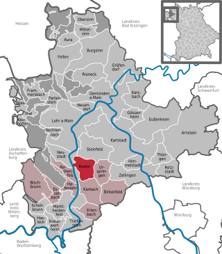
Roden is a community in the Main-Spessart district in the Regierungsbezirk of Lower Franconia (Unterfranken) in Bavaria, Germany and a member of the Verwaltungsgemeinschaft of Marktheidenfeld.

<span class="mw-page-title-main">Schollbrunn</span> Municipality in Bavaria, Germany

Schollbrunn is a community in the Main-Spessart district in the Regierungsbezirk of Lower Franconia (Unterfranken) in Bavaria, Germany and a member of the Verwaltungsgemeinschaft of Kreuzwertheim. It has a population of over 900.

<span class="mw-page-title-main">Steinfeld, Bavaria</span> Municipality in Bavaria, Germany

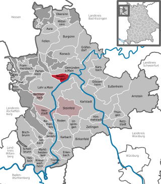
Steinfeld is a community in the Main-Spessart district in the Regierungsbezirk of Lower Franconia (Unterfranken) in Bavaria, Germany and a member of the Verwaltungsgemeinschaft of Lohr am Main.

<span class="mw-page-title-main">Triefenstein</span> Municipality in Bavaria, Germany

Markt Triefenstein is a market community in the Main-Spessart district in the Regierungsbezirk of Lower Franconia (Unterfranken) in Bavaria, Germany. It was created in 1978 out of the villages Homburg am Main, Lengfurt, Rettersheim and Trennfeld.

<span class="mw-page-title-main">Erlenbach bei Marktheidenfeld</span> Municipality in Bavaria, Germany

Erlenbach bei Marktheidenfeld is a community in the Main-Spessart district in the Regierungsbezirk of Lower Franconia in Bavaria, Germany and a member of the Verwaltungsgemeinschaft of Marktheidenfeld. It has given itself the title Weinort mit Herz – Wine Town with Heart.

The County of Rieneck was a comital domain within the Holy Roman Empire that lay in what is now northwestern Bavaria. It bore the same name as its original ruling family, the Counts of Rieneck, from whom the county and its main seat, the town of Rieneck, got their names.

<span class="mw-page-title-main">Hafenlohr (river)</span> River in Germany

Hafenlohr is a river of Bavaria, Germany. It is around 28 km (17 mi) long and discharges into the Main at the town of Hafenlohr. The Hafenlohr is located in the districts of Aschaffenburg and Main-Spessart in the Lower Franconia region.

<span class="mw-page-title-main">Neustadt am Main Abbey</span> German Benedictine monastery, 738–1803

Neustadt am Main Abbey was an abbey of the Benedictine Order in Neustadt am Main, Bavaria, Germany. It existed from the 8th century until the dissolution of abbeys in the course of secularization in 1803. During its heyday in the early Middle Ages, the abbey was a political power that vied for regional influence with the Prince-bishops of Würzburg, the Archbishops of Mainz and the Counts of Rieneck. Today its location is occupied by a monastery operated by the nuns of the "Dominican Order of Saint Catherine of Siena", also known as Kloster Neustadt. The former abbey church today serves as the Catholic parish church for Neustadt.

References

  1. Liste der ersten Bürgermeister/Oberbürgermeister in kreisangehörigen Gemeinden, Bayerisches Landesamt für Statistik, 15 July 2021.
  2. Genesis Online-Datenbank des Bayerischen Landesamtes für Statistik Tabelle 12411-003r Fortschreibung des Bevölkerungsstandes: Gemeinden, Stichtag (Einwohnerzahlen auf Grundlage des Zensus 2011).
  3. 1 2 3 4 5 6 7 8 9 Schumacher, Karin; Schumacher, Hans-Jürgen (2003). Zeitreise durch den Spessart (German). Wartberg Verlag. ISBN   3-8313-1075-0.
  4. "Bürgermeisterwahl in Rothenfels: Gram neuer Bürgermeister". 16 March 2014.
  5. Description and explanation of Rothenfels’s arms