Lower Franconia

Last updated
Lower Franconia
Unterfranken (German)
Flag of Lower Franconia.svg
Unterfranken Wappen.svg
Locator map RB Unterfranken in Bavaria.svg
Map of Bavaria highlighting Lower Franconia
Country Germany
State Bavaria
Region seat Würzburg
Government
   District President Eugen Ehmann
Area
  Total8,530.99 km2 (3,293.83 sq mi)
Population
 (31 December 2022) [1]
  Total1,334,376
  Density160/km2 (410/sq mi)
GDP
[2]
  Total€56.994 billion (2021)
Website www.regierung.unterfranken.bayern.de

Lower Franconia (German : Unterfranken) is one of seven districts of Bavaria, Germany. The districts of Lower, Middle and Upper Franconia make up the region of Franconia. It consists of nine districts and 308 municipalities (including three cities).

Contents

History

After the founding of the Kingdom of Bavaria the state was totally reorganised and, in 1808, divided into 15 administrative government regions (German: Regierungsbezirke, singular Regierungsbezirk ), in Bavaria called Kreise (singular: Kreis). They were created in the fashion of the French departements, quite even in size and population, and named after their main rivers.

In the following years, due to territorial changes (e. g. loss of Tyrol, addition of the Palatinate), the number of Kreise was reduced to 8. One of these was the Untermainkreis (Lower Main District). In 1837 king Ludwig I of Bavaria renamed the Kreise after historical territorial names and tribes of the area. This also involved some border changes or territorial swaps. Thus the name Untermainkreis changed to Lower Franconia and Aschaffenburg, but the city name was dropped in the middle of the 20th century, leaving just Lower Franconia.

From 1933, the regional Nazi Gauleiter , Otto Hellmuth, (who had renamed his party Gau "Mainfranken") insisted on renaming the government district Mainfranken as well. He encountered resistance from Bavarian state authorities but finally succeeded in having the name of the district changed, effective 1 June 1938. [3] After 1945 the name Unterfranken was restored.

The municipal reform (Kreisreform) of June 1972 consolidated the 22 country districts of Lower Franconia into nine.

New districtFormer district(s)
AschaffenburgAschaffenburg, Alzenau
Bad KissingenBad Kissingen, Bad Brückenau, Hammelburg
Haßberge Ebern, Haßfurt, Hofheim in Unterfranken, part of Gerolzhofen
KitzingenKitzingen, part of Gerolzhofen
Main-SpessartGemünden, Karlstadt, Lohr, part of Marktheidenfeld
MiltenbergMiltenberg, Obernburg, part of Marktheidenfeld
Rhön-Grabfeld Bad Neustadt an der Saale, Königshofen, Mellrichstadt
SchweinfurtSchweinfurt, part of Gerolzhofen
WürzburgWürzburg, Ochsenfurt, part of Gerolzhofen, part of Marktheidenfeld


Unterfranken is the north-west part of Franconia and consists of three district-free cities (Kreisfreie Städte) and nine country districts (Landkreise).

The major portion of the Franconian wine region is situated in Lower Franconia.

Economy

The Gross domestic product (GDP) of the region was 53.7 billion € in 2018, accounting for 1.6% of German economic output. GDP per capita adjusted for purchasing power was 37,500 € or 124% of the EU27 average in the same year. The GDP per employee was 102% of the EU average. [4]

Coat of arms

The coat of arms includes the "Franconian Rake" (the arms of Duchy of Franconia) in the upper portion, the "Rennfähnlein  [ de ]", a banner, quarterly argent (silver) and gules (red), on a lance or (gold), in bend, on an azure (blue) field, associated with Würzburg in the lower left quadrant, and a white/silver wheel on a red field symbolizing the clerical state of Mainz, in the lower right quadrant.

Area and population

City or DistrictPopulation (2013)Area (km2)Communities
City of Aschaffenburg 67,7485.22%620.7%10.3%
City of Schweinfurt 51,9184.00%360.4%10.3%
City of Würzburg 124,1549,57%881.0%10.3%
Aschaffenburg 172,52113.30%6998.2%3210.4%
Bad Kissingen 103,0037.94%1,13713.3%268.4%
Haßberge 84,1366.49%95611.2%268.4%
Kitzingen 88,0256.79%6848.0%3110.1%
Main-Spessart 126,4589.75%1,32215.5%4013.0%
Miltenberg 127,9809.87%7168.4%3210.4%
Rhön-Grabfeld 80,0656.17%1,02212.0%3712.0%
Schweinfurt 112,9168.71%8429.9%299.4%
Würzburg 158,13212.19%96811.3%5216.9%
Total1,297,056100.0%8,531100.0%308100.0%
Historical population
1910710,943
1939844,732
19501,038,930
19611,089,983
19701,181,309
19871,202,711
20021,344,300
20051,341,481
20101,318,695
20151,306,048
20191,317,619

Main sights

Wurzburg Residenz 1973 Wurzburg 02.JPG
Würzburg Residenz
Aschaffenburg, Johannisburg Aschaffenburg, Schloss Johannisburg, 09-08-2015, 005.jpg
Aschaffenburg, Johannisburg

Next to the former episcopal residence cities of Würzburg (with Veitshöchheim) and Aschaffenburg, the towns of Miltenberg, Amorbach and Werneck, the scenic attractions of the River Main including the Mainschleife at Volkach and the low mountain ranges of the Rhön with the spa town Bad Kissingen and of the Spessart with Mespelbrunn Castle belong to the major tourist attractions.

Notable people from Lower Franconia

Institutes of higher education

See also

Related Research Articles

<span class="mw-page-title-main">Bavaria</span> State in Germany

Bavaria, officially the Free State of Bavaria, is a state in the southeast of Germany. With an area of 70,550.19 km2 (27,239.58 sq mi), it is the largest German state by land area, comprising roughly a fifth of the total land area of Germany. With over 13 million inhabitants, it is the second most populous German state behind North Rhine-Westphalia, but due to its large physical size its population density is below the German average. Major cities include Munich, Nuremberg, and Augsburg.

<span class="mw-page-title-main">Franconia</span> Cultural region of Germany in Bavaria

Franconia is a region of Germany, characterised by its culture and East Franconian dialect . Franconia is made up of the three Regierungsbezirke of Lower, Middle and Upper Franconia in Bavaria, the adjacent, Franconian-speaking, South Thuringia, south of the Thuringian Forest—which constitutes the language boundary between Franconian and Thuringian—and the eastern parts of Heilbronn-Franconia in Baden-Württemberg.

<span class="mw-page-title-main">Upper Franconia</span> Regierungsbezirk in Bavaria, Germany

Upper Franconia is a Regierungsbezirk of the state of Bavaria, southern Germany. It forms part of the historically significant region of Franconia, the others being Middle Franconia and Lower Franconia, which are all now part of the German Federal State of Bayern (Bavaria).

<span class="mw-page-title-main">Middle Franconia</span> Regierungsbezirk in Bavaria, Germany

Middle Franconia is one of the three administrative regions of Franconia, Germany, in the west of Bavaria bordering the state of Baden-Württemberg. The administrative seat is Ansbach; the most populous and largest city is Nuremberg.

<span class="mw-page-title-main">Upper Bavaria</span> Regierungsbezirk in Bavaria, Germany

Upper Bavaria is one of the seven administrative districts of Bavaria, Germany.

<span class="mw-page-title-main">Lower Bavaria</span> Regierungsbezirk in Bavaria, Germany

Lower Bavaria is one of the seven administrative regions of Bavaria, Germany, located in the east of the state. It consists of nine districts and 258 municipalities.

<span class="mw-page-title-main">Upper Palatinate</span> Regierungsbezirk (administrative district) in Bavaria, Germany

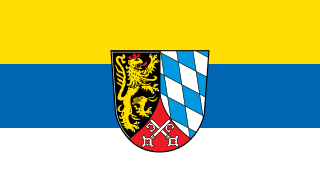
The Upper Palatinate is an administrative district in the east of Bavaria, Germany. It consists of seven districts and 226 municipalities, including three cities.

Main-Spessart is a Landkreis (district) in the northwest of Bavaria, Germany. It is located in Lower Franconia and derives its name from the river Main and the wooded hills of the Spessart.

<span class="mw-page-title-main">East Franconian German</span> Dialect

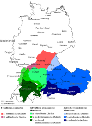
East Franconian or Mainfränkisch, usually referred to as Franconian in German, is a dialect which is spoken in Franconia, the northern part of the federal state of Bavaria and other areas in Germany around Nuremberg, Bamberg, Coburg, Würzburg, Hof, Bayreuth, Meiningen, Bad Mergentheim, and Crailsheim. The major subgroups are Unterostfränkisch, Oberostfränkisch and Südostfränkisch.

<span class="mw-page-title-main">Franconian Circle</span> Imperial circle of the Holy Roman Empire

The Franconian Circle was an Imperial Circle established in 1500 in the centre of the Holy Roman Empire. It comprised the eastern part of the former Franconian stem duchy—roughly corresponding with the present-day Bavarian Regierungsbezirke of Upper, Middle and Lower Franconia—while western Rhenish Franconia belonged to the Upper Rhenish Circle. The title of a "Duke of Franconia" was claimed by the Würzburg bishops.

<span class="mw-page-title-main">Kingdom of Bavaria</span> 1806–1918 kingdom in Central Europe

The Kingdom of Bavaria was a German state that succeeded the former Electorate of Bavaria in 1806 and continued to exist until 1918. With the unification of Germany into the German Empire in 1871, the kingdom became a federated state of the new empire and was second in size, power, and wealth only to the leading state, the Kingdom of Prussia.

<span class="mw-page-title-main">Otto Hellmuth</span> German politician and Nazi Party official (1896–1968)

Otto Hellmuth was a member of the Nazi Party and the Gauleiter in Lower Franconia (Unterfranken) from 1928 to 1945.

<span class="mw-page-title-main">Alzenau</span> Town in Bavaria, Germany

Alzenau is a town in the north of the Aschaffenburg district in the Regierungsbezirk of Lower Franconia (Unterfranken) in Bavaria, Germany. Until 1 July 1972, Alzenau was the district seat of the now abolished district of the same name and has a population of around 19,000.

<span class="mw-page-title-main">Gemünden am Main</span> Town in Bavaria, Germany

Gemünden am Main is a town in the Main-Spessart district in the Regierungsbezirk of Lower Franconia (Unterfranken) in Bavaria, Germany and lies roughly 40 km down the Main from Würzburg. Gemünden has around 10,000 inhabitants.

<span class="mw-page-title-main">Aura im Sinngrund</span> Municipality in Bavaria, Germany

Aura im Sinngrund is a community in the Main-Spessart district in the Regierungsbezirk of Lower Franconia (Unterfranken) in Bavaria, Germany and a member of the Verwaltungsgemeinschaft of Burgsinn.

<span class="mw-page-title-main">Gau Munich-Upper Bavaria</span> Administrative division of Nazi Germany

The Gau Munich–Upper Bavaria was an administrative division of Nazi Germany in Upper Bavaria from 1933 to 1945. From 1930 to 1933, it was the regional subdivision of the Nazi Party in that area.

<span class="mw-page-title-main">Gau Main Franconia</span> Administrative division of Nazi Germany

The Gau Main Franconia, formed as Gau Lower Franconia on 1 March 1929 and renamed Gau Main Franconia on 30 July 1935, was an administrative division of Nazi Germany in Lower Franconia, Bavaria, from 1933 to 1945. Before that, from 1929 to 1933, it was the regional subdivision of the Nazi Party in that area.

<span class="mw-page-title-main">SV Heidingsfeld</span> German football club

The SV Heidingsfeld is a German association football club from the Heidingsfeld suburb of Würzburg, Bavaria. For this reason, the club is sometimes also referred to as SVH Würzburg.

<span class="mw-page-title-main">Untermainkreis</span>

The Untermainkreis was one of the administrative districts of the Kingdom of Bavaria between 1806 and 1837 named after its main river Main. It was the predecessor of the administrative district of Lower Franconia. Administrative headquarters were in Würzburg.

<span class="mw-page-title-main">Franconian Rake</span> Coat of Arms of the Franconia region in Germany

The Franconian Rake is the name given to the coat of arms of the region of Franconia in Germany. It is described heraldically as per fess dancetty of three points gules and argent. The points represent a stylised heraldic rake.

References

  1. Genesis Online-Datenbank des Bayerischen Landesamtes für Statistik Tabelle 12411-003r Fortschreibung des Bevölkerungsstandes: Gemeinden, Stichtag (Einwohnerzahlen auf Grundlage des Zensus 2011)
  2. "EU regions by GDP, Eurostat" . Retrieved 18 September 2023.
  3. "Mainfranken – Historisches Lexikon Bayerns". www.historisches-lexikon-bayerns.de (in German).
  4. "Regional GDP per capita ranged from 30% to 263% of the EU average in 2018". Eurostat.