Greiz is a town in the state of Thuringia, Germany, and is the capital of the district of Greiz. Greiz is situated in eastern Thuringia, 100 kilometres (62 mi) east of the state capital Erfurt, on the White Elster river.
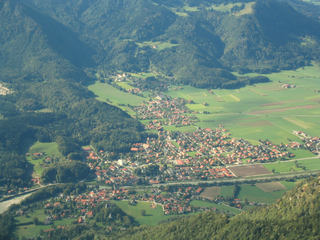
Marquartstein is a municipality in the southeastern part of Bavaria, Germany and is part of the Verwaltungsgemeinschaft Marquartstein and Staudach-Egerndach. It is situated in a region called Chiemgau, approximately 10 km south of Lake Chiemsee between Munich and Salzburg. Most of the area is situated in the valley of the river Tiroler Achen, which separates the village into two parts. Marquartstein is at the edge of the Alps. Its geographical location is 47°46′N12°28′E.

Grafing bei München is a town in the district of Ebersberg, Upper Bavaria, Germany.

Baunach is a town in the Upper Franconian district of Bamberg and the seat of the administrative community (Verwaltungsgemeinschaft) of Baunach. Until administrative reform in 1972, Baunach belonged to the Lower Franconian district of Ebern.
Ludwigsstadt is a town in the district of Kronach, in the Upper Franconian region of Bavaria, Germany.

Scheinfeld is a town in the Neustadt (Aisch)-Bad Windsheim district, in Bavaria, Germany. It is situated 14 km northwest of Neustadt (Aisch), and 40 km east of Würzburg. Schloss Schwarzenberg is adjacent to the town. The town is home to an Adidas testing factory.

Seßlach is a town in the district of Coburg, in northern Bavaria, Germany. It is situated 12 km southwest of Coburg and has a population close to 4,000.

Bad Bocklet is a municipality in the district of Bad Kissingen in Bavaria in Germany. It is a market town and a health spa.

Buttenheim is a market town in the Upper Franconian district of Bamberg and lies in the Regnitz Valley between Bamberg and Nuremberg, Germany.

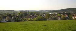
Gerach is a community in the Upper Franconian district of Bamberg and a member of the administrative community (Verwaltungsgemeinschaft) of Baunach. It lies in the Naturpark Haßberge roughly 20 km north of Bamberg and roughly 10 km south of Ebern.

Pfarrweisach is a municipality in the district of Haßberge in Bavaria in Germany.
Collenberg is a community in the Miltenberg district in the Regierungsbezirk of Lower Franconia (Unterfranken) in Bavaria, Germany. It has a population of about 2,400.

Schwangau is a municipality in the district of Ostallgäu in Bavaria, Germany. The village lies 4 km from the larger town of Füssen and just 1.5 km from Hohenschwangau, a collection of tourist-oriented facilities adjacent to the major tourist attractions of Schloss Neuschwanstein and Schloss Hohenschwangau.

Kallmünz is a municipality in the district of Regensburg in Bavaria, Germany. Located on Naab River about 25 km north of Regensburg, Kallmünz has preserved a beautiful medieval center. The main attractions are the ruins of the Kallmünz Castle above the town on a cliff and the old stone bridge over the Naab River. The Russian painter Wassily Kandinsky and the German expressionist painter Gabriele Münter met in Kallmünz during the summer of 1903. Since then, Kallmünz has been the constant home of a small art colony.

Bad Grönenbach is a market town in the district of Unterallgäu in Bavaria, Germany. It belongs to the region of Upper Swabia and the headquarters of the Gemeindeverband of the same name.

Erlabrunn is a municipality in the district of Würzburg in Bavaria, Germany, situated on the left bank of the river Main. It forms an administrative division together with its neighbour Margetshöchheim. It is known for its viticulture and its orcharding.
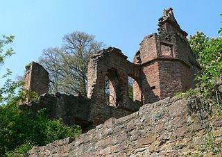
Bramberg Castle is the ruin of a Würzburg castle in the Haßberge hills in the county of Haßberge in Lower Franconia, Bavaria Germany.

Rotenhan Castle is a castle ruin about two kilometres north of the village of Eyrichshof in Lower Franconia in the south German state of Bavaria. Eyrichshof lies within the borough of Ebern in the district of Haßberge. The castle is the ancestral home (Stammsitz) of the House of Rotenhan, a family of imperial knights.

Haßberge Nature Park is a park of 804 km2 (310 sq mi) located in the north east of Franconian Keuperland in Bavaria, Germany.

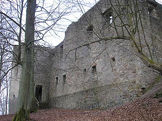
Rauheneck Castle is a ruined administrative castle of the Bishopric of Würzburg in the Haßberge in the county of Haßberge, Lower Franconia, Bavaria (Germany). The site, which was badly in need of repair, was closed until 2006 due to the danger of collapse but has been accessible again since the start of, as yet unfinished, emergency repair work.