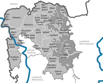
Aschaffenburg is a town in northwest Bavaria, Germany. The town of Aschaffenburg, despite being its administrative seat, is not part of the district of Aschaffenburg.
Offenbach is a Kreis (district) in the south of Hesse, Germany and is part of the Frankfurt/Rhine-Main Metropolitan Region. Neighbouring districts are Main-Kinzig, Aschaffenburg, Darmstadt-Dieburg, Groß-Gerau and the cities of Darmstadt, Frankfurt and Offenbach.

Spessart is a Mittelgebirge, a range of low wooded mountains, in the States of Bavaria and Hesse in Germany. It is bordered by the Vogelsberg, Rhön and Odenwald. The highest elevation is the Geiersberg at 586 metres above sea level.
Main-Kinzig-Kreis is a Kreis (district) in the east of Hesse, Germany. Neighboring districts are Wetteraukreis, Vogelsbergkreis, Fulda, Bad Kissingen, Main-Spessart, Aschaffenburg, Offenbach and the district-free cities of Offenbach and Frankfurt.
Main-Spessart is a Landkreis (district) in the northwest of Bavaria, Germany. It is located in Lower Franconia and derives its name from the river Main and the wooded hills of the Spessart.
Miltenberg is a Landkreis (district) in Bavaria, Germany. It is bounded by the city of Aschaffenburg, the districts of Aschaffenburg and Main-Spessart, and the states of Baden-Württemberg and Hesse.

Schöllkrippen is a market community in the Aschaffenburg district in the Regierungsbezirk of Lower Franconia (Unterfranken) in Bavaria, Germany and seat of the Verwaltungsgemeinschaft of Schöllkrippen. It has a total population of around 4,300 (2020).

Lohr am Main is a town in the Main-Spessart district in the Regierungsbezirk of Lower Franconia (Unterfranken) in Bavaria, Germany and the seat of the Verwaltungsgemeinschaft of Lohr am Main. It has a population of around 15,000.

Alzenau is a town in the north of the Aschaffenburg district in the Regierungsbezirk of Lower Franconia (Unterfranken) in Bavaria, Germany. Until 1 July 1972, Alzenau was the district seat of the now abolished district of the same name and has a population of around 19,000.

Rieneck is a town in the Main-Spessart district in the Regierungsbezirk of Lower Franconia (Unterfranken) in Bavaria, Germany.

Kleinostheim is a community in the Aschaffenburg district in the Regierungsbezirk of Lower Franconia (Unterfranken) in Bavaria, Germany.

Sommerkahl is a community in the Aschaffenburg district in the Regierungsbezirk of Lower Franconia (Unterfranken) in Bavaria, Germany and a member of the Verwaltungsgemeinschaft of Schöllkrippen. It has a population of around 1,300 (2020).

Stockstadt am Main is a market community in the Aschaffenburg district in the Regierungsbezirk of Lower Franconia (Unterfranken) in Bavaria, Germany.

Weibersbrunn is a community with a population of close to 2,000 in the Aschaffenburg district in the Regierungsbezirk of Lower Franconia (Unterfranken) in Bavaria, Germany.

Frammersbach is a market community in the Main-Spessart district in the Regierungsbezirk of Lower Franconia (Unterfranken) in Bavaria, Germany. In the early modern period, people from Frammersbach achieved international renown as drivers of wagons on the most important trans-European trade routes. Today, Frammersbach has a population of around 4,500.

Neustadt am Main is a community in the Main-Spessart district in the Regierungsbezirk of Lower Franconia (Unterfranken) in Bavaria, Germany and a member of the Verwaltungsgemeinschaft Lohr am Main.
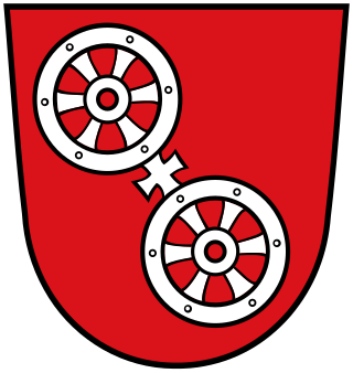
The Wheel of Mainz or Mainzer Rad, in German, was the coat of arms of the Archbishopric of Mainz and thus also of the Electorate of Mainz (Kurmainz), in Rhineland-Palatinate, Germany. It consists of a silver wheel with six spokes on a red background. The wheel can also be found in stonemasons' carvings and similar objects. Currently, the City of Mainz uses a double wheel connected by a silver cross.
Flörsbachtal is a municipality in the Main-Kinzig district, in Hesse, Germany. It has a population close to 2,400. Flösbachtal contains both the oldest parish and the youngest settlement established in the Spessart hills. Located within the municipal territory is the Hermannskoppe, the highest elevation in the Hessian part of the Spessart and the Wiesbüttmoor, a rare hanging bog.
The Rhine-Main Railway, is a railway line in southern Germany from Mainz via Darmstadt to Aschaffenburg. It was built by the Hessian Ludwig Railway and opened on 1 August 1858 and is one of the oldest railways in Germany. Until 1862, when the railway bridge over the Rhine river constructed and assembled by MAN-Werk Gustavsburg was finished, a train ferry operated on the river.
The Main Limes, also called the Nasser Limes, was built around 90 AD and, as part of the Upper Germanic-Rhaetian Limes, formed the frontier of the Roman Empire in the area between the present day villages of Großkrotzenburg and Bürgstadt. In this section the limes adjoined the River Main (Moenus), which forms a natural boundary for about 50 kilometres here, so "Main" refers to the river.