Kahl am Main

Last updated
Kahl a. Main
Kahl Rathaus (01).jpg
Town hall
Wappen Kahl.svg
Location of Kahl a. Main within Aschaffenburg district
Kahl am Main in AB.svgJohannesbergWiesener ForstForst Hain im SpessartHeinrichsthaler ForstHeinrichsthaler ForstWaldaschaffer ForstSchöllkrippener ForstSailaufer ForstRohrbrunner ForstRothenbucher ForstGoldbachWiesenKrombachHaibach
Germany adm location map.svg
Red pog.svg
Kahl a. Main
Bavaria location map.svg
Red pog.svg
Kahl a. Main
Coordinates: 50°4′5″N9°0′24″E / 50.06806°N 9.00667°E / 50.06806; 9.00667
Country Germany
State Bavaria
Admin. region Unterfranken
District Aschaffenburg
Government
   Mayor (201723) Jürgen Seitz [1] (SPD)
Area
  Total10.63 km2 (4.10 sq mi)
Elevation
110 m (360 ft)
Population
 (2022-12-31) [2]
  Total8,437
  Density790/km2 (2,100/sq mi)
Time zone UTC+01:00 (CET)
  Summer (DST) UTC+02:00 (CEST)
Postal codes
63796
Dialling codes 06188
Vehicle registration AB
Website www.kahl-main.de

Kahl am Main (officially Kahl a. Main) is a community in the Aschaffenburg district in the Regierungsbezirk of Lower Franconia (Unterfranken) in Bavaria, Germany. It has around 7,500 inhabitants. [3]

Contents

Geography

Location

Constituent communities Gemeinde Kahl am Main.svg
Constituent communities

Kahl am Main lies 107 m above sea level and includes, at the mouth of the river Kahl, the lowest-lying point in the state of Bavaria and covers an area of approximately 11 km2. It also lies right on the boundary with Hesse in a favourable location with regards to transport between Aschaffenburg and Hanau (Main-Kinzig-Kreis). [4]

Demographics

Kahl has a rate of population growth between 0.1% and 0.1%. It also has an aging population with the largest age group being 65 and above in 2014. The average age has increased from 46 in 2005 to 47.5 in 2014. Even though there have been fewer births than deaths consistently since 1975, the city has experiences slight growth due to newcomers. [3]

Governance

Community council

Kahler Sandhase Kahler Sandhas.JPG
Kahler Sandhase

The council is made up of 21 council members, counting the mayor.

CSU SPD Wählergemeinschaft GREENS Total
2008972321 seats

(as at municipal election held on 2 March 2008)

Coat of arms

The community's arms might be described thus: Party per bend sinister wavy, the parting surmounted by a bend sinister wavy argent, azure a coney courant of the first in bend sinister, gules a demi-wheel spoked of six of the first couped in bend sinister.

The community of Kahl lies on a bend in the river Main, and this is referenced by the bend sinister wavy (slanted wavy stripe) in the arms. This also refers to the river Kahl, which is part of the community's name. The tinctures argent and gules (silver and red) and the half-wheel refer to Electoral Mainz's former overlordship in the community. The silver hare recalls the Kahl dwellers’ nickname Sandhasen (“Sand Hares”) – sometimes also Sandbauern (“Sand Farmers”) – arising from the community's lower crop yields than in other Main communities due to the sandy soil. Since 1806 the place has belonged to Bavaria, which is reflected in the tinctures argent and azure (blue). [5]

The arms have been borne since 19 July 1960.

Town twinning

The latter relationship is a "town friendship".

Economy

Within Kahl's municipal limits, roughly 350 businesses have their seats, among them Kopp (500 employees), [6] Linde Material Handling GmbH (550 employees) [7] and Singulus Technologies (350 employees), [8] three big companies in engine building and electronics. Business taxes from all businesses lie between €3,300,000 and €9,100,000 each year.

Culture and sightseeing

Clubs

Clubs include the Feuerwehr FF-Kahl (fire brigade) and the Rotes Kreuz Kahl. There was an umbrella group, the Vereinsgemeinschaft Kahl (“Kahl Club Community”), to which many of the local clubs belonged, and which, among other things, staged the yearly Kerb . [9] Even though the community dissolved in 2016, [10] the Kerb has been taken up by several other communities and is now organized by volunteers. [11]

Buildings

Town hall and watertower Kahler Rathaus Wasserturm.JPG
Town hall and watertower
Timber-frame house (17th century) Kahler Fachwerkhaus.JPG
Timber-frame house (17th century)
Bakehouse (about 1650) Kahler Backes.JPG
Bakehouse (about 1650)

Parks

Nature

Typical sand slopes at the Campingsee Kahler See.JPG
Typical sand slopes at the Campingsee
"Witches' Oak" monument Kahler Hexeneiche.JPG
“Witches’ Oak” monument

The local scenery is characterized by forest and water, which make up 75% of the municipal area. The quarry lakes of the Kahl Lake Plateau (Kahler Seenplatte) with outdoor bathing at Waldseebad (former Emma-Nord stripmine) and Campingsee (Freigericht-Ost) with one of Bavaria's biggest campsites as well as the angling ponds of the former Emma-Süd pit and the Vorspessartseen (lakes) offer opportunities for angling, boating, swimming and surfing. Five hiking trails and a fitness course (Vitaparcours) lead through the Kahl nature areas with their typical vegetation and sand flora. Many wild herbs, hogweed, wild carrot and malva grow in the meadows alongside the Main, where there is also a small campsite. [20]

The natural monument Hexeneiche (“Witches’ Oak”) on the B 8 was destroyed on 7 August 1970 by a lightning strike. The oak, known to have already been standing in the Thirty Years' War, had to be felled on 8 June 1971. A newly planted oak and a memorial stone recall the witchhunts in the early 17th century, to which 69 women and 21 men fell victim here. [21]

On holidays, the railway line between Kahl am Main and Schöllkrippen is often used for “Historic Steam Locomotive Journeys”.

Landscape on the Main near the mouth of the Kahl Kahler Mainufer.JPG
Landscape on the Main near the mouth of the Kahl

The Kahltal-Spessart cycling-hiking trail starts at Kahl.

Infrastructure

Transport

Kahl am Main lies in a favourable location with regards to transport between Aschaffenburg and Hanau with good transport links to Autobahn A 45 (Gießen - Aschaffenburg) as well as Autobahn A 3 (Frankfurt am Main - Würzburg - Nuremberg - Munich). Bundesstraßen 8 (Aschaffenburg - Hanau), 43 and 43A link Kahl am Main to the Frankfurt Rhine Main Region. [22]

The Main–Spessart railway from Frankfurt to Würzburg, where it connects to Nuremberg and Munich, runs through the Kahl am Main station, which is served by Regional-Express services. Here the Kahlgrundbahn (to Schöllkrippen) branches off. Kahl has no goods station. The nearest ones are in Hanau and Aschaffenburg.

The nearest airport is Frankfurt Airport.

Utilities

Nuclear power station

Despite the name, the first nuclear reactor in Germany, the Versuchsatomkraftwerk Kahl ("Kahl Experimental Nuclear Power Station") was not built in Kahl am Main but in the neighbouring municipality of Großwelzheim (now part of Karlstein am Main). There were three reasons the plant was not named after Großwelzheim:

  • Kahl was easier to pronounce for the U.S. personnel;
  • Kahl had a railway station; Großwelzheim did not;
  • the plant got its mail from the Kahl Post Office.

The power plant was shut down in 1985 and the reactors have been dismantled. [23]

Related Research Articles

<span class="mw-page-title-main">Battle of Dettingen</span> 1743 battle during War of Austrian Succession

The Battle of Dettingen took place on 27 June 1743 during the War of the Austrian Succession at Dettingen in the Electorate of Mainz, Holy Roman Empire. It was fought between a Pragmatic Army, composed of the British, Hanoverian and Austrian troops, and a French army commanded by the duc de Noailles.

<span class="mw-page-title-main">Schöllkrippen</span> Municipality in Bavaria, Germany

Schöllkrippen is a market community in the Aschaffenburg district in the Regierungsbezirk of Lower Franconia (Unterfranken) in Bavaria, Germany and seat of the Verwaltungsgemeinschaft of Schöllkrippen. It has a total population of around 4,300 (2020).

<span class="mw-page-title-main">Karlstein am Main</span> Municipality in Bavaria, Germany

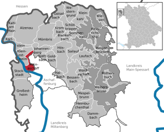
Karlstein am Main is a municipality in the Aschaffenburg district in the Regierungsbezirk of Lower Franconia (Unterfranken) in Bavaria, Germany. It is the westernmost settlement in Bavaria. Karlstein's Ortsteile are Dettingen and Großwelzheim, the former being notable as the site of the Battle of Dettingen during the War of the Austrian Succession. In the 20th century, the town was the site of the, now decommissioned, Großwelzheim Nuclear Power Plant.

<span class="mw-page-title-main">Hainburg, Germany</span> Municipality in Hesse, Germany

Hainburg is a municipality of just under 14,400 inhabitants in the Offenbach district in the Regierungsbezirk of Darmstadt in Hesse, Germany.

<span class="mw-page-title-main">Lohr am Main</span> Place in Bavaria, Germany

Lohr am Main is a town in the Main-Spessart district in the Regierungsbezirk of Lower Franconia (Unterfranken) in Bavaria, Germany and the seat of the Verwaltungsgemeinschaft of Lohr am Main. It has a population of around 15,000.

<span class="mw-page-title-main">Alzenau</span> Town in Bavaria, Germany

Alzenau is a town in the north of the Aschaffenburg district in the Regierungsbezirk of Lower Franconia (Unterfranken) in Bavaria, Germany. Until 1 July 1972, Alzenau was the district seat of the now abolished district of the same name and has a population of around 19,000.

<span class="mw-page-title-main">Erlensee</span> Town in Hesse, Germany

Erlensee is a town in the Main-Kinzig district, in Hesse, Germany. It is situated on the river Kinzig, 5 km northeast of Hanau. It was formed in 1970 by the merger, in 1970, of the towns of Langendiebach and Rückingen. The name deduces from the abundant alders at the lakes in this area.

<span class="mw-page-title-main">Aschaffenburg Hauptbahnhof</span>

Aschaffenburg Hauptbahnhof is the main station of Aschaffenburg in the German state of Bavaria. It is located on the busy Ruhr– Frankfurt–Nuremberg–Munich/Vienna rail corridor. Deutsche Bahn classifies it as a category 2 station. It forms the boundary between the city centre and the district of Damm.

<span class="mw-page-title-main">Glattbach</span> Municipality in Bavaria, Germany

Glattbach is a community in the Aschaffenburg district (landkreis) in the administrative region (regierungsbezirk) of Lower Franconia (Unterfranken) in Bavaria, Germany. It has around 3,300 inhabitants (2020). The town is located in a valley north of Aschaffenburg town on the western edge of the Spessart range.

<span class="mw-page-title-main">Kleinkahl</span> Municipality in Bavaria, Germany

Kleinkahl is a community in the Aschaffenburg district in the Regierungsbezirk of Lower Franconia (Unterfranken) in Bavaria, Germany, and a member of the Verwaltungsgemeinschaft of Schöllkrippen. Kleinkahl has around 1,800 inhabitants.

<span class="mw-page-title-main">Mainaschaff</span> Municipality in Bavaria, Germany

Mainaschaff is a community in the Aschaffenburg district in the Regierungsbezirk of Lower Franconia (Unterfranken) in Bavaria, Germany. It has a population of around 9,000 (2020).

<span class="mw-page-title-main">Obersinn</span> Municipality in Bavaria, Germany

Obersinn is a market community in the Main-Spessart district in the Regierungsbezirk of Lower Franconia (Unterfranken) in Bavaria, Germany and a member of the Verwaltungsgemeinschaft of Burgsinn.

<span class="mw-page-title-main">Elsenfeld</span> Municipality in Bavaria, Germany

Elsenfeld is a market community in the Miltenberg district in the Regierungsbezirk of Lower Franconia (Unterfranken) in Bavaria, Germany. It is located on the river Main between the hills of the Spessart, east of the river, and Odenwald, west of the river. Elsenfeld has a total population of around 9,000.

<span class="mw-page-title-main">Wheel of Mainz</span> Coat of arms of Mainz

The Wheel of Mainz or Mainzer Rad, in German, was the coat of arms of the Archbishopric of Mainz and thus also of the Electorate of Mainz (Kurmainz), in Rhineland-Palatinate, Germany. It consists of a silver wheel with six spokes on a red background. The wheel can also be found in stonemasons' carvings and similar objects. Currently, the City of Mainz uses a double wheel connected by a silver cross.

<span class="mw-page-title-main">Großkrotzenburg</span> Municipality in Hesse, Germany

Großkrotzenburg is a municipality in the Main-Kinzig district, in Hesse, Germany. It has a population of around 7,500.

<span class="mw-page-title-main">Ludwig Western Railway</span>

The Ludwig Western Railway is a German railway line that was originally funded by the Kingdom of Bavaria. It runs from Bamberg via Würzburg to Aschaffenburg and on into the former "Kurhessian" Hanau.

<span class="mw-page-title-main">Würzburg–Aschaffenburg railway</span>

The Würzburg–Aschaffenburg railway is an 89 kilometre-long railway line in the Bavarian province of Lower Franconia. It runs from Würzburg via Gemünden (Main) to Aschaffenburg. It is particularly important for long-distance and goods traffic because it links the Rhine-Main conurbation immediately northwest of Aschaffenburg with the Lower Franconian city of Würzburg and beyond it to the metropoles of Nuremberg and Munich. The German name derives from the fact that it initially runs parallel to the River Main and then cuts through the Spessart hills. It was opened on 22 June 1854 by the Frankfurt-Hanau Railway Company and is one of the oldest railways in Germany.

The Rhine-Main Railway, is a railway line in southern Germany from Mainz via Darmstadt to Aschaffenburg. It was built by the Hessian Ludwig Railway and opened on 1 August 1858 and is one of the oldest railways in Germany. Until 1862, when the railway bridge over the Rhine river constructed and assembled by MAN-Werk Gustavsburg was finished, a train ferry operated on the river.

<span class="mw-page-title-main">Hanau Hauptbahnhof</span> Railway station in Germany

Hanau Hauptbahnhof is a railway station in Hanau in the German state of Hesse, and is a major railway junction east of Frankfurt am Main. It was opened in 1867, but the current building was built in the late 1960s. It is located about 1.5 kilometres (0.93 mi) south-east of central Hanau. It is classified by Deutsche Bahn (DB) as a category 2 station and has many train services, including Intercity Express, regional and S-Bahn services.

<span class="mw-page-title-main">Frankfurt Rhine-Main</span> Place in Germany

The Rhine-Main Metropolitan Region, often simply referred to as Frankfurt Rhine-Main, Frankfurt Rhine-Main area or Rhine-Main area, is the second-largest metropolitan region in Germany after Rhine-Ruhr, with a total population exceeding 5.8 million. The metropolitan region is located in the central-western part of Germany, and stretches over parts of three German states: Hesse, Rhineland-Palatinate, and Bavaria. The largest cities in the region are Frankfurt am Main, Wiesbaden, Mainz, Darmstadt, Offenbach, Worms, Hanau, and Aschaffenburg.

References

  1. Liste der ersten Bürgermeister/Oberbürgermeister in kreisangehörigen Gemeinden, Bayerisches Landesamt für Statistik, accessed 19 July 2021.
  2. Genesis Online-Datenbank des Bayerischen Landesamtes für Statistik Tabelle 12411-003r Fortschreibung des Bevölkerungsstandes: Gemeinden, Stichtag (Einwohnerzahlen auf Grundlage des Zensus 2011)
  3. 1 2 "Statistik_kommunal_2015_2.xlsm" (PDF). bayern.de.
  4. "Info-Ort.de: Kahl am Main". Kahl am Main (in German). Retrieved 2017-10-28.
  5. "KahlProof" (PDF). spessartprojekt.de.
  6. "Impressum - Heinrich Kopp GmbH". www.kopp.eu (in German). Retrieved 2017-10-28.
  7. "▷ Linde Material Handling GmbH & Co. KG Werk III ✅ | Tel. (06188) 41... ☎ - 11880.com". www.11880.com (in German). Retrieved 2017-10-28.
  8. AG, SINGULUS TECHNOLOGIES (2017-08-08). "Disclaimer". www.singulus.com. Retrieved 2017-10-28.
  9. "Heute beginnt die Kerb-Planung in Kahl". main-echo.de (in German). 2014-03-06. Retrieved 2017-10-28.
  10. "Kahl: Vereinsgemeinschaft vor Aus, Kerb soll bleiben". main-echo.de (in German). 2016-09-22. Retrieved 2017-10-28.
  11. "Kahler Kerb 2017: Vereine suchen Helfer". main-echo.de (in German). 2016-12-13. Retrieved 2017-10-28.
  12. Darmstadt, IDL Software GmbH. "Weihnachtsmarkt auf Schloss Emmerichshofen - Weihnachten 2017". www.weihnachtsmarkt-deutschland.de (in German). Retrieved 2017-10-28.
  13. "Freizeit - Main-Echo". main-echo.de (in German). Retrieved 2017-10-28.
  14. "KW-Kahl-Taf-12" (PDF). spessartprojekt.de.
  15. "Interaktive Karte « KulturRegion FrankfurtRheinMain". www.krfrm.de (in German). Retrieved 2017-10-28.
  16. "Gemeinde Kahl am Main". www.kahl-main.de (in German). Retrieved 2017-10-28.
  17. "Der Mühlen-Radwanderweg Kahlgrund". www.steffenreichel.homepage.t-online.de. Retrieved 2017-10-28.
  18. "► Zoo-Infos.de ◄ - die Zoo-Datenbank".
  19. "Vogelpark-Planungen liegen auf Eis". main-echo.de (in German). 2012-01-06. Retrieved 2017-10-28.
  20. "Kahler See | Seen.de". www.seen.de (in German). Retrieved 2017-10-28.
  21. Großkrotzenburg, Museum. "Museum Großkrotzenburg | Illustration - Ortsgeschichte". www.museum-grosskrotzenburg.de. Retrieved 2017-10-28.
  22. "Gemeinde Kahl am Main". www.kahl-main.de (in German). Retrieved 2017-10-28.
  23. "Anfang und Ende des ersten deutschen Meilers". FOCUS Online (in German). Retrieved 2017-10-28.