This article has multiple issues. Please help improve it or discuss these issues on the talk page . (Learn how and when to remove these messages)
|
Mespelbrunn | |
|---|---|
 | |
 Coat of arms | |
Location of Mespelbrunn within Aschaffenburg district 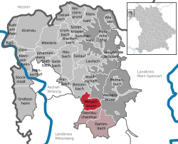 | |
 Location of Mespelbrunn | |
 Mespelbrunn  Mespelbrunn | |
| Coordinates: 49°55′N9°17′E / 49.917°N 9.283°E | |
| Country | Germany |
| State | Bavaria |
| Admin. region | Unterfranken |
| District | Aschaffenburg |
| Municipal assoc. | Mespelbrunn |
| Government | |
| • Mayor (2023–29) | Stephanie Fuchs [1] (CSU) |
| Area | |
• Total | 15.53 km2 (6.00 sq mi) |
| Elevation | 269 m (883 ft) |
| Population (2023-12-31) [2] | |
• Total | 2,283 |
| • Density | 147.0/km2 (380.7/sq mi) |
| Time zone | UTC+01:00 (CET) |
| • Summer (DST) | UTC+02:00 (CEST) |
| Postal codes | 63875 |
| Dialling codes | 06092 |
| Vehicle registration | AB, ALZ |
| Website | www.mespelbrunn.de |
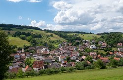


Mespelbrunn is a municipality in the Aschaffenburg district in the Regierungsbezirk of Lower Franconia (Unterfranken) in Bavaria, Germany and a member of the Verwaltungsgemeinschaft (municipal association) of Mespelbrunn, whose seat is in Heimbuchenthal.
Contents
- Geography
- Location
- Subdivision
- Neighbouring municipalities
- History
- Government
- Municipal council
- Coat of arms
- Attractions
- Schloss Mespelbrunn
- Wallfahrtskirche Hessenthal
- Herrnbildkapelle
- Notable people
- References
- External links
It is the site of Mespelbrunn Castle, one of the most famous landmarks of the Spessart region, and of the Wallfahrtskirche Hessenthal, for more than 700 years the destination of a Christian pilgrimage.


