Leidersbach

Last updated
Leidersbach
DEU Leidersbach COA.svg
Coat of arms
Location of Leidersbach within Miltenberg district
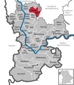
Leidersbach in MIL.svg
Germany adm location map.svg
Red pog.svg
Leidersbach
Bavaria location map.svg
Red pog.svg
Leidersbach
Coordinates: 49°54′N9°13′E / 49.900°N 9.217°E / 49.900; 9.217 Coordinates: 49°54′N9°13′E / 49.900°N 9.217°E / 49.900; 9.217
Country Germany
State Bavaria
Admin. region Unterfranken
District Miltenberg
Subdivisions4 Ortsteile
Government
   Mayor (201723) Michael Schüßler [1]
Area
  Total19.81 km2 (7.65 sq mi)
Elevation
196 m (643 ft)
Population
 (2020-12-31) [2]
  Total4,727
  Density240/km2 (620/sq mi)
Time zone UTC+01:00 (CET)
  Summer (DST) UTC+02:00 (CEST)
Postal codes
63849
Dialling codes 06028, 06092
Vehicle registration MIL
Website www.leidersbach.de

Leidersbach is a community in the Miltenberg district in the Regierungsbezirk of Lower Franconia (Unterfranken) in Bavaria, Germany.

Contents

Geography

Location

Leidersbach lies roughly 10 km south of Aschaffenburg in the Spessart.

Neighbouring communities

From the north, clockwise: Forst Hohe Wart (gemeindefreies Gebiet), Mespelbrunn, Heimbuchenthal, Hausen, Kleinwallstadt, Sulzbach am Main.

Subdivisions

Leidersbach's Ortsteile are Leidersbach, Ebersbach  [ de ], Roßbach  [ de ] and Volkersbrunn  [ de ].

History

The Schlossberg, a hill between Ebersbach and Soden, part of neighbouring Sulzbach, was already inhabited in Neolithic times and in the period of the Hallstatt culture (see Attractions).

The founding of the community itself came about in the Middle Ages. By comparing the place with other places with similar name origins, it can be inferred that the places ending in —bach (meaning “brook” in German) were likely founded in Carolingian times in the late 8th century. Ebersbach had its first documentary mention in 1183, and Leidersbach and Roßbach had theirs in 1200. Volkersbrunn's first written reference is from 1248.

Already by this time, these villages belonged to Electoral Mainz. When this state was dissolved by the 1803 Reichsdeputationshauptschluss , the villages passed to the newly formed Principality of Aschaffenburg, with which they passed in 1814 (by this time it had become a part of the Grand Duchy of Frankfurt) to the Kingdom of Bavaria.

Amalgamations

On 1 January 1972, the formerly self-administering communities of Leidersbach, Ebersbach, Roßbach and Volkersbrunn merged into a new unitary community of Leidersbach.

Economy

Leidersbach business is characterized by the clothing industry. Moreover, there are businesses in software development and marketing as well as an analytical laboratory.

Attractions

Altenburg

The Altenburg is an oval hilltop fortress on the Schlossberg, right at the municipal border between Sulzbach and Leidersbach. The circular rampart measures about 365 m west to east, with a width of up to 180 m. The remains of the rampart consist of an inner and an outer wall and a moat. Excavations in 2008 and 2009 indicated at least three distinct periods of use. The first period was during the Neolithic Michelsberg culture, as evidenced by findings of ceramic fragments and stone artefacts. No extant structures can be attributed to this period, however. The second phase of use was during the late Hallstatt period (700 to 450 BC). The inner wall (a Pfostenschlitzmauer) was built during this time. It likely had a fortified gate to the southeast. This inner wall was destroyed by a fire. The outer wall is the most recent, but it has not been possible so far to date it. It may have seen use well into early medieval times, possibly as a refuge castle for the population of the surrounding villages. [3]

A map from the 19th century shows remains of a square building near the southeast of the structure. However, this area was especially affected by locals using the Altenburg as a source of construction material and today no trace of the building remains. Additional damage to the structures resulted from post-World War II use as a training ground for US Armed Forces stationed nearby. They pitched tents in the area and dug trenches at the Altenburg. [4]

Others

Religion

The community of Leidersbach is overwhelmingly Roman Catholic.

Sports

Handball

The Rhein-Main Bienen (“Rhine-Main Bees”; formerly HSG Sulzbach/Leidersbach) represents the community in the Handball-Bundesliga der Frauen (Women's Federal Handball League). The club won the 2003-2004 championship, which brought with it advancement to the Hesse Upper League (Oberliga). The next season, the team became Hesse champions and won the subsequent elimination series with solid wins. In the Regionalliga Südwest the team took the championship with trainer Peter David in the 2005-2006 season unbeaten, moving up to the Second Bundesliga. HSG finished the season up as Second Bundesliga champions, and a playoff win against TuS Weibern earned the team a spot in the First Bundesliga. Furthermore, the women's team managed to fill the Sparkassen-Arena in Elsenfeld with 3,500 spectators at a cup game against German champions 1. FC Nürnberg. Besides this team, there are two men's teams, a further women's team and several youth teams play.

Government

Community council

The council is made up of 16 council members with seats apportioned thus:

Mayor

Michael Schüßler (CWG) has been elected in a special election 2017 after the incumbent Friedrich Wöhrl (CSU) passed away early that year.

Coat of arms

The community's arms might be described thus: A fess wavy argent, in chief vert three bars of the first surmounting which a pair of tailor's shears expanded in saltire their points in chief of the first, in base gules a wheel spoked of six of the first.

The escutcheon’s upper half with the tailor’s shears and narrow stripes (“bars”) is a reference to the tailor's craft and the clothing factories that were so important to the community's development in the 19th and 20th centuries. The shield's lower half shows the Wheel of Mainz in its historical tinctures, and this stands for the community's history as an Electoral Mainz holding until 1803. The arms have been borne since 1979. [5]

Infrastructure

Ermergency services

BRK Leidersbach is a local chapter of the Bavarian Red Cross (Bayerisches Rotes Kreuz) in the Miltenberg-Obernburg district association. It was founded on 16 March 1955. The Red Cross association is housed at Kolpingstraße 2 and has maintained the fields of the Youth Red Cross, Preparedness, SEG-Nord (emergency management) and, since 1 March 1984, a certified first responder with his own donation-financed, volunteered ambulance based at the Leidersbach fire station.

Education

As of 2007 the following institutions existed in :

There is also a youth education centre in the former monastery on the Klosterberg in Ebersbach.

Notable people

Related Research Articles

Spessart

Spessart is a Mittelgebirge, a range of low wooded mountains, in the States of Bavaria and Hesse in Germany. It is bordered by the Vogelsberg, Rhön and Odenwald. The highest elevation is the Geiersberg at 586 metres above sea level.

Miltenberg is a Landkreis (district) in Bavaria, Germany. It is bounded by the city of Aschaffenburg, the districts of Aschaffenburg and Main-Spessart, and the states of Baden-Württemberg and Hesse.

Miltenberg Place in Bavaria, Germany

Miltenberg is a town in the Regierungsbezirk of Lower Franconia (Unterfranken) in Bavaria, Germany. It is the seat of the like-named district and has a population of over 9,000.

Schöllkrippen Place in Bavaria, Germany

Schöllkrippen is a market community in the Aschaffenburg district in the Regierungsbezirk of Lower Franconia (Unterfranken) in Bavaria, Germany and seat of the Verwaltungsgemeinschaft of Schöllkrippen. It has a total population of around 4,000.

Mömbris Place in Bavaria, Germany

Mömbris is a community – since 31 January 1964 a market community – in the Aschaffenburg district in the Regierungsbezirk of Lower Franconia (Unterfranken) in Bavaria, Germany. With over 11,000 inhabitants, Mömbris is the district's fifth largest community.

Klingenberg am Main Place in Bavaria, Germany

Klingenberg am Main is a town in the Miltenberg district in the Regierungsbezirk of Lower Franconia (Unterfranken) in Bavaria, Germany. It has a population of around 6,200 and is located on both banks of the river Main.

Obernburg Place in Bavaria, Germany

Obernburg am Main is a town in the Miltenberg district in the Regierungsbezirk of Lower Franconia (Unterfranken) in Bavaria, Germany. It has a population of around 8,500.

Kleinwallstadt Place in Bavaria, Germany

Kleinwallstadt is a market community in the Miltenberg district in the Regierungsbezirk of Lower Franconia (Unterfranken) in Bavaria, Germany and the seat of the like-named Verwaltungsgemeinschaft.

Mespelbrunn Place in Bavaria, Germany

Mespelbrunn is a community in the Aschaffenburg district in the Regierungsbezirk of Lower Franconia (Unterfranken) in Bavaria, Germany and a member of the Verwaltungsgemeinschaft of Mespelbrunn, whose seat is in Heimbuchenthal.

Frammersbach Place in Bavaria, Germany

Frammersbach is a market community in the Main-Spessart district in the Regierungsbezirk of Lower Franconia (Unterfranken) in Bavaria, Germany. In the early modern period, people from Frammersbach achieved international renown as drivers of wagons on the most important trans-European trade routes. Today, Frammersbach has a population of around 4,500.

Neustadt am Main Place in Bavaria, Germany

Neustadt am Main is a community in the Main-Spessart district in the Regierungsbezirk of Lower Franconia (Unterfranken) in Bavaria, Germany and a member of the Verwaltungsgemeinschaft Lohr am Main.

Eichenbühl Place in Bavaria, Germany

Eichenbühl is a community in the Miltenberg district in the Regierungsbezirk of Lower Franconia (Unterfranken) in Bavaria, Germany.

Großwallstadt Place in Bavaria, Germany

Großwallstadt is a community in the Miltenberg district in the Regierungsbezirk of Lower Franconia (Unterfranken) in Bavaria, Germany.

Hausen, Miltenberg Place in Bavaria, Germany

Hausen is a community in the Miltenberg district in the Regierungsbezirk of Lower Franconia (Unterfranken) in Bavaria, Germany and a member of the Verwaltungsgemeinschaft of Kleinwallstadt.

Kirchzell Place in Bavaria, Germany

Kirchzell is a market community in the Miltenberg district in the Regierungsbezirk of Lower Franconia (Unterfranken) in Bavaria, Germany.

Mönchberg Place in Bavaria, Germany

Mönchberg is a market community in the Miltenberg district in the Regierungsbezirk of Lower Franconia (Unterfranken) in Bavaria, Germany. It is the seat of the Verwaltungsgemeinschaft of Mönchberg and a state-recognized climatic spa (Luftkurort).

Neunkirchen, Lower Franconia Place in Bavaria, Germany

Neunkirchen is a municipality in the Miltenberg district in the Regierungsbezirk of Lower Franconia (Unterfranken) in Bavaria, Germany and a member of the Verwaltungsgemeinschaft of Erftal, whose seat is in Bürgstadt.

Sulzbach am Main Place in Bavaria, Germany

Sulzbach am Main is a market municipality in the Miltenberg district in the Regierungsbezirk of Lower Franconia (Unterfranken) in Bavaria, Germany.

Wheel of Mainz

The Wheel of Mainz or Mainzer Rad, in German, was the coat of arms of the Archbishopric of Mainz and thus also of the Electorate of Mainz (Kurmainz), in Rhineland-Palatinate, Germany. It consists of a silver wheel with six spokes on a red background. The wheel can also be found in stonemasons' carvings and similar objects. Currently, the City of Mainz uses a double wheel connected by a silver cross.

Biebergemünd Place in Hesse, Germany

Biebergemünd is a municipality in the Main-Kinzig district, in Hesse, Germany. It has a population of over 8,000 and lies in the wooded hills of the Spessart.

References

  1. Liste der ersten Bürgermeister/Oberbürgermeister in kreisangehörigen Gemeinden, Bayerisches Landesamt für Statistik, accessed 19 July 2021.
  2. "Tabellenblatt "Daten 2", Statistischer Bericht A1200C 202041 Einwohnerzahlen der Gemeinden, Kreise und Regierungsbezirke". Bayerisches Landesamt für Statistik und Datenverarbeitung (in German). June 2021.
  3. "Altenburg - Kurz und bündig (German)". Archäologisches Spessartprojekt. Archived from the original on 20 May 2015. Retrieved 1 June 2015.
  4. "Die Forschungsgeschichte der Altenburg (German)". Archäologisches Spessartprojekt. Archived from the original on 20 May 2015. Retrieved 1 June 2015.
  5. Leidersbach’s arms at the Haus der Bayerischen Geschichte [ permanent dead link ]