Weilbach, Germany

Last updated
Weilbach
DEU Weilbach COA.svg
Coat of arms
Location of Weilbach within Miltenberg district
Weilbach in MIL.svg
Germany adm location map.svg
Red pog.svg
Weilbach
Bavaria location map.svg
Red pog.svg
Weilbach
Coordinates: 49°41′N09°12′E / 49.683°N 9.200°E / 49.683; 9.200 Coordinates: 49°41′N09°12′E / 49.683°N 9.200°E / 49.683; 9.200
Country Germany
State Bavaria
Admin. region Unterfranken
District Miltenberg
Subdivisions7 Ortsteile
Government
   Mayor (202026) Robin Haseler [1] (SPD)
Area
  Total27.28 km2 (10.53 sq mi)
Elevation
152 m (499 ft)
Population
 (2020-12-31) [2]
  Total2,175
  Density80/km2 (210/sq mi)
Time zone UTC+01:00 (CET)
  Summer (DST) UTC+02:00 (CEST)
Postal codes
63937
Dialling codes 09373
Vehicle registration MIL
Website www.weilbach.de

Weilbach is a market municipality in the Miltenberg district in the Regierungsbezirk of Lower Franconia (Unterfranken) in Bavaria, Germany.

Contents

Geography

Location

Weilbach lies in the Bavarian part of the Odenwald (range).

Weilbach church and old school Weilbach 2003.JPG
Weilbach church and old school

Constituent communities

The municipality is divided into the centres of Weilbach, Weckbach, Gönz, Reuenthal, Ohrenbach, Wiesenthal and Sansenhof.

History

In 1201, Weilbach had its first documentary mention. The knight Cunrat von Wilenbach was witness to a land deal of the House of Dürn, which he served. The Lords of Dürn were Hohenstaufen ministeriales and from 1171 to 1272 protective Vögte of the Amorbach Monastery.

For most of its history, Weilbach was under Electoral Mainz lordship. In 1803, Weilbach was passed to the Principality of Leiningen, and along with this passed shortly thereafter to the Grand Duchy of Baden. A few years later (1810), Weilbach ended up with the Grand Duchy of Hesse-Darmstadt. Since 1816 it has belonged to Bavaria.

In 1977, under municipal reform, Weckbach with its outlying centres of Gönz, Ohrnbach, Wiesenthal and Sansenhof was amalgamated with Weilbach.

Politics

Mayor

The mayor is Robin Haseler (SPD), he was first elected in 2020.

Municipal council

The council is made up of 14 council members, with seats apportioned thus:

There are otherwise no further, active local party groups in Weilbach. The SPD, though, has a Young Socialist working group.

Coat of arms

The municipality's arms might be described thus: Per mantle argent a fountain with three spouts, dexter, affronty and sinister, before which a trough azure, in chief dexter gules a wheel spoked of six of the first, in chief sinister a cogwheel spoked of four and toothed of twelve of the first.

The Wheel of Mainz refers to Electoral Mainz's long rule over the community, as do the tinctures argent and gules (silver and red). The cogwheel refers to the long tradition of metalworking in the municipal area. The fountain is the municipality's landmark.

The arms have been borne since 1969. [3]

Culture and sightseeing

Buildings

There are the church and the historic centre with the Drei-Röhren-Brunnen (“Three-Pipe Fountain”). From the Gotthardsruine, half of which is within Amorbach’s town limits, there is a panoramic view over the Odenwald and on into the Spessart (range).

Gotthardsruine

Pano Gotthard 2002.JPG
Panoramic view from the Gotthardsruine

The Gotthardsruine, a Gothic column basilica, stands on the summit of the nearby Gotthardsberg. From here there are views into seven dales and the surrounding hills. The “Gotthard”, once “Frankenberg”, was for a time a robber-baron's castle and then later a convent.

The first written account that has come down to the present goes back to the year 714. It was then that the Gaugraf (regional count) Ruthard von Frankenberg supposedly called the missionaries Saint Pirmin and Amor to the “Gotthard”. During the German Peasants' War (1525), rebels laid the “Gotthard” in rubble and ashes. In 1631, the church was built anew by Abbot Erhard Landecker. On 8 June 1714, the Gotthard Basilica was struck by lightning and destroyed. The ruins, such as they are today, were restored in 1956.

Dreiröhrenbrunnen

The Dreiröhrenbrunnen (“Three-Pipe Fountain”) is found in Weilbach's community core, right at an intersection. It has a great sandstone trough with a Baroque relief. The water squirts out through three spouts. The fountain even appears in the municipality's coat of arms, held as it is to be one of its landmarks. At the opening of Carnival (known locally as Fasching) by the Weilbacher Frösch Carnival Company on 11 November, the water is dyed green.

Mudmühle

On the northwest route out of Weilbach stands the mill with its Renaissance gable converted by Mainz court master builder Ambrosius Brosamer in 1585.

Hallsteine

These are a collection of interesting ancient stones on the Hallhöhe (heights) in Weilbach's west. A signposted hiking trail leads to this natural monument.

Glockenspiel

The Glockenspiel was added to the Town Hall in December 1991 with 24 bells. These ring daily at 9:10, 12:10 and 18:10. This was financed by a private initiative by Weilbach citizens and clubs under the umbrella of the Heimatverein Weilbach-Weckbach e.V. (local historical society).

Since 25 June 2006, the Glockenspiel – now expanded to 37 bells – plays in a specially built tower on the old schoolyard. One particularity is that the Glockenspiel can also be played by hand, making it a rarity in Bavaria, where there are only five functional carillons.

Economy and infrastructure

At the beginning of the 19th century, the factory der Eisenhammer (“The Iron Hammer”), now belonging to The Linde Group, was founded. Several scale-modelling businesses that make moulded models consequently settled here.

A pallet factory works wood from the Odenwald.

At the new Gewerbegebiet-Süd (“Commercial Area South”), a logistics business and craft businesses have set up shop.

Famous people

Honorary citizens

Paul Breunig (b. 6 January 1926; d. 24 August 2006) began working at the post of municipal secretary in 1946. From 1956 to 1985, he was mayor of the market municipality of Weilbach. Beginning in 1966 he was a Member of the Kreistag (district assembly) for three terms. From 1967 to 1984, as Chairman of the Bavarian Municipal Assembly (Bayerischer Gemeindetag), he took on responsibility for the Miltenberg district chapter.

For his outstanding services, he was awarded the Bundesverdienstkreuz with Ribbon. Furthermore, he was the recipient of the Mayor's Medal in Gold of the market municipality of Weilbach. In 1985 he became an honorary citizen and in 1991 he was awarded the Kommunale Verdienstmedaille (a Bavarian medal for municipal service) in silver. On 24 August 2006, Paul Breunig died in his hometown, Weilbach.

Sons and daughters of the town

Related Research Articles

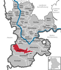
Miltenberg is a Landkreis (district) in Bavaria, Germany. It is bounded by the city of Aschaffenburg, the districts of Aschaffenburg and Main-Spessart, and the states of Baden-Württemberg and Hesse.

Miltenberg Place in Bavaria, Germany

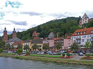
Miltenberg is a town in the Regierungsbezirk of Lower Franconia (Unterfranken) in Bavaria, Germany. It is the seat of the like-named district and has a population of over 9,000.

Amorbach Place in Bavaria, Germany

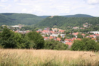
Amorbach is a town in the Miltenberg district in the Regierungsbezirk of Lower Franconia (Unterfranken) in Bavaria, Germany, with some 4,000 inhabitants. It is situated on the small river Mud, in the northeastern part of the Odenwald.

Obernburg Place in Bavaria, Germany

Obernburg am Main is a town in the Miltenberg district in the Regierungsbezirk of Lower Franconia (Unterfranken) in Bavaria, Germany. It has a population of around 8,500.

Kleinwallstadt Place in Bavaria, Germany

Kleinwallstadt is a market community in the Miltenberg district in the Regierungsbezirk of Lower Franconia (Unterfranken) in Bavaria, Germany and the seat of the like-named Verwaltungsgemeinschaft.

Heimbuchenthal Place in Bavaria, Germany

Heimbuchenthal is a community in the Aschaffenburg district in the Regierungsbezirk of Lower Franconia (Unterfranken) in Bavaria, Germany, and the seat of the Verwaltungsgemeinschaft of Mespelbrunn. It is also a state-recognized recreational resort (Erholungsort).

Bürgstadt Place in Bavaria, Germany

Bürgstadt is a market community in the Miltenberg district in the Regierungsbezirk of Lower Franconia (Unterfranken) in Bavaria, Germany and the seat of the Verwaltungsgemeinschaft of Erftal. Bürgstadt is a winegrowing community in the wine region of Franken. It has a population of around 4,300.

Eichenbühl Place in Bavaria, Germany

Eichenbühl is a community in the Miltenberg district in the Regierungsbezirk of Lower Franconia (Unterfranken) in Bavaria, Germany.

Elsenfeld Place in Bavaria, Germany

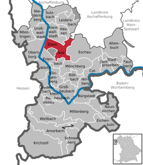
Elsenfeld is a market community in the Miltenberg district in the Regierungsbezirk of Lower Franconia (Unterfranken) in Bavaria, Germany. It is located on the river Main between the hills of the Spessart, east of the river, and Odenwald, west of the river. Elsenfeld has a total population of around 9,000.

Faulbach Place in Bavaria, Germany

Faulbach is a municipality in the Miltenberg district in the Regierungsbezirk of Lower Franconia (Unterfranken) in Bavaria, Germany. It has a population of around 2,600.

Großheubach Place in Bavaria, Germany

Großheubach is a market community in the Miltenberg district in the Regierungsbezirk of Lower Franconia (Unterfranken) in Bavaria, Germany.

Großwallstadt Place in Bavaria, Germany

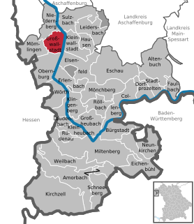
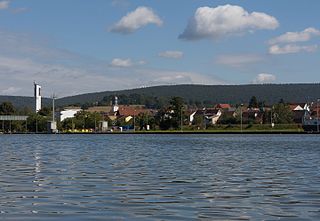
Großwallstadt is a community in the Miltenberg district in the Regierungsbezirk of Lower Franconia (Unterfranken) in Bavaria, Germany.

Kirchzell Place in Bavaria, Germany

Kirchzell is a market community in the Miltenberg district in the Regierungsbezirk of Lower Franconia (Unterfranken) in Bavaria, Germany.

Kleinheubach Place in Bavaria, Germany

Kleinheubach is a market community in the Miltenberg district in the Regierungsbezirk of Lower Franconia (Unterfranken) in Bavaria, Germany and the seat of the like-named Verwaltungsgemeinschaft. It has a population of around 3,600.

Laudenbach, Bavaria Place in Bavaria, Germany

For other places with the same name, see Laudenbach (disambiguation)

Neunkirchen, Lower Franconia Place in Bavaria, Germany

Neunkirchen is a municipality in the Miltenberg district in the Regierungsbezirk of Lower Franconia (Unterfranken) in Bavaria, Germany and a member of the Verwaltungsgemeinschaft of Erftal, whose seat is in Bürgstadt.

Röllbach Place in Bavaria, Germany

Röllbach is a municipality in the Miltenberg district in the Regierungsbezirk of Lower Franconia (Unterfranken) in Bavaria, Germany and a member of the Verwaltungsgemeinschaft of Mönchberg.

Rüdenau Place in Bavaria, Germany

Rüdenau is a municipality in the Miltenberg district in the Regierungsbezirk of Lower Franconia (Unterfranken) in Bavaria, Germany and a member of the Verwaltungsgemeinschaft of Kleinheubach.

Schneeberg, Bavaria Place in Bavaria, Germany

Schneeberg is a market municipality in the Miltenberg district in the Regierungsbezirk of Lower Franconia (Unterfranken) in Bavaria, Germany.

Wildenberg Castle (Kirchzell)

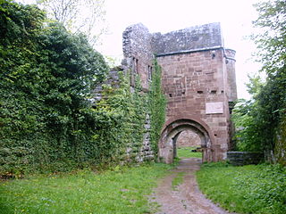
Wildenberg Castle, also called the Wildenburg, is a ruined, Hohenstaufen period castle in the Odenwald hills in Germany. It is located in the parish of Preunschen in the municipality of Kirchzell, in the Lower Franconian district of Miltenberg in Bavaria.

References

  1. Liste der ersten Bürgermeister/Oberbürgermeister in kreisangehörigen Gemeinden, Bayerisches Landesamt für Statistik, 15 July 2021.
  2. "Tabellenblatt "Daten 2", Statistischer Bericht A1200C 202041 Einwohnerzahlen der Gemeinden, Kreise und Regierungsbezirke". Bayerisches Landesamt für Statistik und Datenverarbeitung (in German). June 2021.
  3. Description and explanation of Weilbach’s arms