Faulbach

Last updated
Faulbach
Faulbach, dorpszicht foto7 2016-08-08 10.40.jpg
View of Faulbach from the Main
Wappen von Faulbach.svg
Location of Faulbach within Miltenberg district
Faulbach in MIL.svg
Germany adm location map.svg
Red pog.svg
Faulbach
Bavaria location map.svg
Red pog.svg
Faulbach
Coordinates: 49°47′N9°27′E / 49.783°N 9.450°E / 49.783; 9.450 Coordinates: 49°47′N9°27′E / 49.783°N 9.450°E / 49.783; 9.450
Country Germany
State Bavaria
Admin. region Unterfranken
District Miltenberg
Subdivisions2 Ortsteile
Government
   Mayor (202026) Wolfgang Hörnig [1] (SPD)
Area
  Total10.97 km2 (4.24 sq mi)
Elevation
142 m (466 ft)
Population
 (2020-12-31) [2]
  Total2,588
  Density240/km2 (610/sq mi)
Time zone UTC+01:00 (CET)
  Summer (DST) UTC+02:00 (CEST)
Postal codes
97906
Dialling codes 09392
Vehicle registration MIL
Website www.faulbach.de

Faulbach is a municipality in the Miltenberg district in the Regierungsbezirk of Lower Franconia (Unterfranken) in Bavaria, Germany. It has a population of around 2,600.

Contents

Geography

Location

Faulbach lies on the right bank of the river Main, between Wertheim am Main and Miltenberg, where it is joined by the Faulbach. Around the municipality lie the hills of the Spessart. At Faulbach, the Main is the border between the states of Bavaria and Baden-Württemberg.

Subdivision

The community has the following Gemarkungen (traditional rural cadastral areas): Breitenbrunn, Faulbach.

History

The Electoral Mainz Amt became, in accordance with the 1803 Reichsdeputationshauptschluss part of Prince Primate von Dalberg’s newly formed Principality of Aschaffenburg, with which it passed in 1814 (by this time it had become a department of the Grand Duchy of Frankfurt) to the Kingdom of Bavaria. In the course of administrative reform in Bavaria, the current community came into being with the Gemeindeedikt (“Municipal Edict”) of 1818.

Demographics

Within town limits, 2,466 inhabitants were counted in 1970, 2,502 in 1987 and in 2000 2,795.

Economy

According to official statistics, there were 465 workers on the social welfare contribution rolls working in producing businesses in 1998. In trade and transport this was 55. In other areas, 126 workers on the social welfare contribution rolls were employed, and 1,064 such workers worked from home. There were 62 processing businesses. Three businesses were in construction, and furthermore, in 1999, there were 10 agricultural operations with a working area of 127 ha, of which 68 ha was cropland and 59 ha was meadowland.

Municipal taxes in 1999 amounted to €1,743,000 (converted), of which net business taxes amounted to €602,000.

Governance

The mayor is Wolfgang Hörnig (SPD).

Coat of arms

The community’s arms might be described thus: Per fess, gules a wheel spoked of six Or and argent a bend wavy azure with a base of grass proper.

The arms come from a village seal from the 17th century. Faulbach ended up in Electoral Mainz’s hands after a territorial swap with the Teutonic Knights in 1484 and stayed with Mainz until the Old Empire came to an end in 1803. The Wheel of Mainz (here shown in gold instead of the silver found in most civic arms that bear this charge) recalls the community’s long history as an Electoral Mainz holding, as do the tinctures gules and argent (red and silver). The wavy fess stands for the community’s namesake brook, while the grass represents the brook's banks. [3]

The arms have been borne since 1956. [4]

Education

In 1999 the following institutions existed in Faulbach:

Related Research Articles

Kleinwallstadt Municipality in Bavaria, Germany

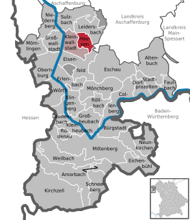
Kleinwallstadt is a market community in the Miltenberg district in the Regierungsbezirk of Lower Franconia (Unterfranken) in Bavaria, Germany and the seat of the like-named Verwaltungsgemeinschaft.

Blankenbach Municipality in Bavaria, Germany

Blankenbach is a community in the Aschaffenburg district in the Regierungsbezirk of Lower Franconia (Unterfranken) in Bavaria, Germany, and a member of the Verwaltungsgemeinschaft of Schöllkrippen.

Heimbuchenthal Municipality in Bavaria, Germany

Heimbuchenthal is a community in the Aschaffenburg district in the Regierungsbezirk of Lower Franconia (Unterfranken) in Bavaria, Germany, and the seat of the Verwaltungsgemeinschaft of Mespelbrunn. It is also a state-recognized recreational resort (Erholungsort).

Kleinkahl Municipality in Bavaria, Germany

Kleinkahl is a community in the Aschaffenburg district in the Regierungsbezirk of Lower Franconia (Unterfranken) in Bavaria, Germany, and a member of the Verwaltungsgemeinschaft of Schöllkrippen. Kleinkahl has around 1,800 inhabitants.

Wiesen, Bavaria Municipality in Bavaria, Germany

Wiesen is a community in the Aschaffenburg district in the Regierungsbezirk of Lower Franconia (Unterfranken) in Bavaria, Germany and a member of the Verwaltungsgemeinschaft of Schöllkrippen. It has around 1,000 inhabitants.

Gräfendorf Municipality in Bavaria, Germany

Gräfendorf is a community in the Main-Spessart district in the Regierungsbezirk of Lower Franconia (Unterfranken) in Bavaria, Germany and a member of the Verwaltungsgemeinschaft of Gemünden am Main.

Himmelstadt Municipality in Bavaria, Germany

Himmelstadt is a community in the Main-Spessart district in the Regierungsbezirk of Lower Franconia (Unterfranken) in Bavaria, Germany and a member of the Verwaltungsgemeinschaft of Zellingen.

Karbach, Bavaria Municipality in Bavaria, Germany

Karbach is a market community in the Main-Spessart district in the Regierungsbezirk of Lower Franconia (Unterfranken) in Bavaria, Germany and a member of the Verwaltungsgemeinschaft of Marktheidenfeld.

Mittelsinn Municipality in Bavaria, Germany

Mittelsinn is a community in the Main-Spessart district in the Regierungsbezirk of Lower Franconia (Unterfranken) in Bavaria, Germany and a member of the Verwaltungsgemeinschaft of Burgsinn.

Neuhütten Municipality in Bavaria, Germany

Neuhütten is a community in the Main-Spessart district in the Regierungsbezirk of Lower Franconia (Unterfranken) in Bavaria, Germany and a member of the Verwaltungsgemeinschaft of Partenstein. It has a population of around 1,100.

Rechtenbach Municipality in Bavaria, Germany

Rechtenbach is a community in the Main-Spessart district in the Regierungsbezirk of Lower Franconia (Unterfranken) in Bavaria, Germany and a member of the Verwaltungsgemeinschaft of Lohr am Main. It has a population of around 1,000.

Collenberg Municipality in Bavaria, Germany

Collenberg is a community in the Miltenberg district in the Regierungsbezirk of Lower Franconia (Unterfranken) in Bavaria, Germany. It has a population of about 2,400.

Dorfprozelten Municipality in Bavaria, Germany

Dorfprozelten is a municipality in the Miltenberg district in the Regierungsbezirk of Lower Franconia (Unterfranken) in Bavaria, Germany. It is one of the oldest settlements on the Lower Main. Sandstone quarrying was a major industry once. The village has also long been known as the home of people involved in inland (river) navigation. Today, Dorfprozelten has a population of close to 1,800.

Eichenbühl Municipality in Bavaria, Germany

Eichenbühl is a community in the Miltenberg district in the Regierungsbezirk of Lower Franconia (Unterfranken) in Bavaria, Germany.

Elsenfeld Municipality in Bavaria, Germany

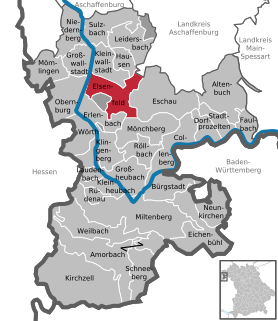
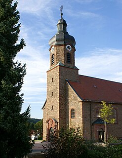
Elsenfeld is a market community in the Miltenberg district in the Regierungsbezirk of Lower Franconia (Unterfranken) in Bavaria, Germany. It is located on the river Main between the hills of the Spessart, east of the river, and Odenwald, west of the river. Elsenfeld has a total population of around 9,000.

Eschau Municipality in Bavaria, Germany

Eschau is a market community in the Miltenberg district in the Regierungsbezirk of Lower Franconia (Unterfranken) in Bavaria, Germany. It has a population of around 3,800.

Großwallstadt Municipality in Bavaria, Germany

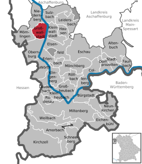
Großwallstadt is a community in the Miltenberg district in the Regierungsbezirk of Lower Franconia (Unterfranken) in Bavaria, Germany.

Hausen, Miltenberg Municipality in Bavaria, Germany

Hausen is a community in the Miltenberg district in the Regierungsbezirk of Lower Franconia (Unterfranken) in Bavaria, Germany and a member of the Verwaltungsgemeinschaft of Kleinwallstadt.

Rüdenau Municipality in Bavaria, Germany

Rüdenau is a municipality in the Miltenberg district in the Regierungsbezirk of Lower Franconia (Unterfranken) in Bavaria, Germany and a member of the Verwaltungsgemeinschaft of Kleinheubach.

Schneeberg, Bavaria Municipality in Bavaria, Germany

Schneeberg is a market municipality in the Miltenberg district in the Regierungsbezirk of Lower Franconia (Unterfranken) in Bavaria, Germany.

References

  1. Liste der ersten Bürgermeister/Oberbürgermeister in kreisangehörigen Gemeinden, Bayerisches Landesamt für Statistik, 15 July 2021.
  2. "Tabellenblatt "Daten 2", Statistischer Bericht A1200C 202041 Einwohnerzahlen der Gemeinden, Kreise und Regierungsbezirke". Bayerisches Landesamt für Statistik (in German). June 2021.
  3. "Further information about the arms from community's website". Archived from the original on 2016-06-20. Retrieved 2018-09-21.
  4. Description and explanation of Faulbach’s arms