Hausen, Miltenberg

Last updated
Hausen
Wappen Hausen (Aschaffenburg).svg
Coat of arms
Location of Hausen within Miltenberg district
Hausen in MIL.svg
Germany adm location map.svg
Red pog.svg
Hausen
Bavaria location map.svg
Red pog.svg
Hausen
Coordinates: 49°52′11″N9°12′37″E / 49.86972°N 9.21028°E / 49.86972; 9.21028 Coordinates: 49°52′11″N9°12′37″E / 49.86972°N 9.21028°E / 49.86972; 9.21028
Country Germany
State Bavaria
Admin. region Unterfranken
District Miltenberg
Municipal assoc. Kleinwallstadt
Subdivisions2 Ortsteile
Government
   Mayor (202026) Michael Bein [1]
Area
  Total8.06 km2 (3.11 sq mi)
Elevation
203 m (666 ft)
Population
 (2020-12-31) [2]
  Total1,857
  Density230/km2 (600/sq mi)
Time zone UTC+01:00 (CET)
  Summer (DST) UTC+02:00 (CEST)
Postal codes
63840
Dialling codes 06022
Vehicle registration MIL
Website www.hausen-spessart.de

Hausen is a community in the Miltenberg district in the Regierungsbezirk of Lower Franconia (Unterfranken) in Bavaria, Germany and a member of the Verwaltungsgemeinschaft (Administrative Community) of Kleinwallstadt.

Contents

Geography

Location

Hausen lies in the Bavarian Lower Main (Bayerischer Untermain) Region.

The community has only the Gemarkung (traditional rural cadastral area) of Hausen.

History

The settlements of Oberhausen and Unterhausen, once part of the Archbishopric of Mainz, became in accordance with the 1803 Reichsdeputationshauptschluss part of Prince Primate von Dalberg’s newly formed Principality of Aschaffenburg, with which it passed in 1814 (by this time it had become a department of the Grand Duchy of Frankfurt) to Bavaria. On 25 April 1856 the two formerly self-administering communities were merged to form the single community of Hausen.

Population development

Within town limits, 1,385 inhabitants were counted in 1970, 1,682 in 1987 and in 2000 1,965.

Politics

Town council

The council is made up of 13 council members, counting the mayor, with seats apportioned thus:

Municipal taxes in 1999 amounted to €674,000 (converted), of which net business taxes amounted to €36,000.

Coat of arms

The community’s arms might be described thus: Sable a sword per bend sinister the point to chief and flammant argent, the whole surmounted by a cross chequy of two Or and gules, in chief dexter a wheel spoked of six of the second, in base sinister an oakleaf per bend sinister acorned of one of the second.

The chequered cross is drawn from the arms once borne by the Counts of Ingelheim, who succeeded the Echter von Mespelbrunn family as feudal lords when the latter died out in 1665. The Wheel of Mainz refers to the Archbishopric of Mainz, which was also once an overlord. The flaming sword is one of Saint Michael’s attributes, and it is to him that the church in Hausen is consecrated. The oakleaf and the acorn stand for Hausen’s geographical location in the Spessart (range).

The arms have been borne since 1988. [3]

Economy and infrastructure

According to official statistics, there were 42 workers on the social welfare contribution rolls working in producing businesses in 1998. In trade and transport this was 0. In other areas, 746 such workers worked from home. There were 4 processing businesses. Two businesses were in construction, and furthermore, in 1999, there were 12 agricultural operations with a working area of 144 ha, of which 83 ha was cropland and 57 ha was meadowland.

Education

In 1999 the following institutions existed in Hausen:

Related Research Articles

Dammbach Place in Bavaria, Germany

Dammbach is a community in the Aschaffenburg district in the Regierungsbezirk of Lower Franconia (Unterfranken) in Bavaria, Germany, and a member of the Verwaltungsgemeinschaft of Mespelbrunn, whose seat is in Heimbuchenthal.

Kleinwallstadt Place in Bavaria, Germany

Kleinwallstadt is a market community in the Miltenberg district in the Regierungsbezirk of Lower Franconia (Unterfranken) in Bavaria, Germany and the seat of the like-named Verwaltungsgemeinschaft.

Blankenbach Place in Bavaria, Germany

Blankenbach is a community in the Aschaffenburg district in the Regierungsbezirk of Lower Franconia (Unterfranken) in Bavaria, Germany, and a member of the Verwaltungsgemeinschaft of Schöllkrippen.

Johannesberg, Bavaria Place in Bavaria, Germany

Johannesberg is a community in the Aschaffenburg district in the Regierungsbezirk of Lower Franconia (Unterfranken) in Bavaria, Germany. It has around 3,900 inhabitants.

Kleinkahl Place in Bavaria, Germany

Kleinkahl is a community in the Aschaffenburg district in the Regierungsbezirk of Lower Franconia (Unterfranken) in Bavaria, Germany, and a member of the Verwaltungsgemeinschaft of Schöllkrippen. Kleinkahl has around 1,800 inhabitants.

Krombach, Bavaria Place in Bavaria, Germany

Krombach is a community in the Aschaffenburg district in the Regierungsbezirk of Lower Franconia (Unterfranken) in Bavaria, Germany and a member of the Verwaltungsgemeinschaft of Schöllkrippen.

Sailauf Place in Bavaria, Germany

Sailauf is a municipality in the Aschaffenburg district in the Regierungsbezirk of Lower Franconia (Unterfranken) in Bavaria, Germany. It has a population of around 3,600.

Waldaschaff Place in Bavaria, Germany

Waldaschaff is a community in the Aschaffenburg district in the Regierungsbezirk of Lower Franconia (Unterfranken) in Bavaria, Germany.

Wiesen, Bavaria Place in Bavaria, Germany

Wiesen is a community in the Aschaffenburg district in the Regierungsbezirk of Lower Franconia (Unterfranken) in Bavaria, Germany and a member of the Verwaltungsgemeinschaft of Schöllkrippen. It has around 1,000 inhabitants.

Bischbrunn Place in Bavaria, Germany

Bischbrunn is a community with around 1,800 (2013) inhabitants in the Main-Spessart district in the Regierungsbezirk of Lower Franconia (Unterfranken) in Bavaria, Germany and a member of the Verwaltungsgemeinschaft of Marktheidenfeld.

Neuhütten Place in Bavaria, Germany

Neuhütten is a community in the Main-Spessart district in the Regierungsbezirk of Lower Franconia (Unterfranken) in Bavaria, Germany and a member of the Verwaltungsgemeinschaft of Partenstein. It has a population of around 1,100.

Rechtenbach Place in Bavaria, Germany

Rechtenbach is a community in the Main-Spessart district in the Regierungsbezirk of Lower Franconia (Unterfranken) in Bavaria, Germany and a member of the Verwaltungsgemeinschaft of Lohr am Main. It has a population of around 1,000.

Schollbrunn Place in Bavaria, Germany

Schollbrunn is a community in the Main-Spessart district in the Regierungsbezirk of Lower Franconia (Unterfranken) in Bavaria, Germany and a member of the Verwaltungsgemeinschaft of Kreuzwertheim. It has a population of over 900.
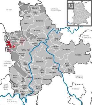
Steinfeld, Bavaria Place in Bavaria, Germany

Steinfeld is a community in the Main-Spessart district in the Regierungsbezirk of Lower Franconia (Unterfranken) in Bavaria, Germany and a member of the Verwaltungsgemeinschaft of Lohr am Main.

Altenbuch Place in Bavaria, Germany

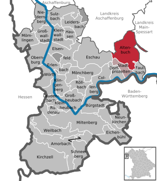
Altenbuch is a community in the Miltenberg district in the Regierungsbezirk of Lower Franconia (Unterfranken) in Bavaria, Germany and a member of the Verwaltungsgemeinschaft of Stadtprozelten. Altenbuch has around 1,200 inhabitants.

Eichenbühl Place in Bavaria, Germany

Eichenbühl is a community in the Miltenberg district in the Regierungsbezirk of Lower Franconia (Unterfranken) in Bavaria, Germany.

Faulbach Place in Bavaria, Germany

Faulbach is a municipality in the Miltenberg district in the Regierungsbezirk of Lower Franconia (Unterfranken) in Bavaria, Germany. It has a population of around 2,600.

Neunkirchen, Lower Franconia Place in Bavaria, Germany

Neunkirchen is a municipality in the Miltenberg district in the Regierungsbezirk of Lower Franconia (Unterfranken) in Bavaria, Germany and a member of the Verwaltungsgemeinschaft of Erftal, whose seat is in Bürgstadt.

Röllbach Place in Bavaria, Germany

Röllbach is a municipality in the Miltenberg district in the Regierungsbezirk of Lower Franconia (Unterfranken) in Bavaria, Germany and a member of the Verwaltungsgemeinschaft of Mönchberg.

Rüdenau Place in Bavaria, Germany

Rüdenau is a municipality in the Miltenberg district in the Regierungsbezirk of Lower Franconia (Unterfranken) in Bavaria, Germany and a member of the Verwaltungsgemeinschaft of Kleinheubach.

References

  1. Liste der ersten Bürgermeister/Oberbürgermeister in kreisangehörigen Gemeinden, Bayerisches Landesamt für Statistik, 15 July 2021.
  2. "Tabellenblatt "Daten 2", Statistischer Bericht A1200C 202041 Einwohnerzahlen der Gemeinden, Kreise und Regierungsbezirke". Bayerisches Landesamt für Statistik und Datenverarbeitung (in German). June 2021.
  3. Description and explanation of Hausen’s arms [ permanent dead link ]