Laudenbach, Bavaria

Last updated

For other places with the same name, see Laudenbach (disambiguation)

Contents

Laudenbach
DEU Laudenbach COA.svg
Location of Laudenbach within Miltenberg district
Laudenbach in MIL.svgHohe Wart (unincorporated area)ForstwaldHohe BergWeilbachSchneebergNeunkirchenLaudenbachHausen
Germany adm location map.svg
Red pog.svg
Laudenbach
Bavaria location map.svg
Red pog.svg
Laudenbach
Coordinates: 49°44′45″N9°10′34″E / 49.74583°N 9.17611°E / 49.74583; 9.17611 Coordinates: 49°44′45″N9°10′34″E / 49.74583°N 9.17611°E / 49.74583; 9.17611
Country Germany
State Bavaria
Admin. region Unterfranken
District Miltenberg
Municipal assoc. Kleinheubach
Government
   Mayor (202026) Stefan Distler [1]
Area
  Total4.94 km2 (1.91 sq mi)
Elevation
127 m (417 ft)
Population
 (2021-12-31) [2]
  Total1,483
  Density300/km2 (780/sq mi)
Time zone UTC+01:00 (CET)
  Summer (DST) UTC+02:00 (CEST)
Postal codes
63925 (formerly 8761)
Dialling codes 09372
Vehicle registration MIL
Website www.laudenbach-am-main.de

Laudenbach is a municipality in the Miltenberg district in the Regierungsbezirk of Lower Franconia (Unterfranken) in Bavaria, Germany and a member of the Verwaltungsgemeinschaft (Administrative Community) of Kleinheubach.

History

Since 1315 Laudenbach was owned by the imperial barons of Fechenbach. In the course of the reorganization of Germany under Napoleon, the place came to the Grand Duchy of Hesse in 1810. With a contract of January 29, 1817, Laudenbach, together with the towns of Umpfenbach, Windischbuchen and Reichartshausen, came to the Kingdom of Bavaria in exchange for Dorndiel, Mosbach and Radheim from the Grand Duchy of Hesse. In 1862 the Miltenberg district office was formed, on whose administrative area Laudenbach was located. During the Nazi Germany Regime, Laudenbach was one of 31 communities which were assigned in the so called 'Landkreis' of Miltenberg. On July 1, 1972, this merged with the district of Obernburg am Main to form the new district of Miltenberg. [3]

Geography

Location

Laudenbach lies right on the Bavarian Lower Main between Miltenberg and Obernburg, and borders on the Odenwald.

It is relatively well linked to the highway network by Bundesstraße 469. The Frankfurt Rhine Main Region’s hub can be reached quickly by car or train.

Neighbouring communities

The next community down the Main is Klingenberg am Main, and the next one upstream is Kleinheubach.

Amalgamations

The hamlet of Brunnthal in Hessen, which belongs to Michelstadt’s outlying centre of Vielbrunn, is co-administered by Laudenbach.

Population development

There has been a slight rise in the community's population over the last few years owing mainly to the opening of new building areas, such as Sommerberg II, Bocksberg.

Politics

Community council

The council is made up of 12 council members with seats apportioned thus:

Mayor

Currently in office is Stefan Distler, elected in 2020.

Coat of arms

The community's arms might be described thus: A bend sinister wavy azure, in chief barry of six Or and gules, in base argent a buffalo's attire sable.

The wavy bend sinister stands for the community's namesake brook. The stripes are drawn from the arms once borne by the Counts of Rieneck. They sold their holdings in Laudenbach in 1315 to the Barons of Fechenbach, who then, in 1385, enfeoffed the Counts with the holding. After they died out in 1559, the community passed to Electoral Mainz. The Barons of Fechenbach died out in their male line in 1892. The buffalo's horn is drawn from their arms. Both these elements symbolize former hegemony.

The arms have been borne since 1970. [4]

Culture and sightseeing

Music

Buildings

Parks

Schlosspark Laudenbach

Natural monuments

A giant tree in the Schlosspark is the oldest living thing in the Miltenberg district.

Regular events

Education

There is a primary school-Hauptschule within the Kleinheubach/Laudenbach/Rüdenau school association.

Related Research Articles

Main-Spessart is a Landkreis (district) in the northwest of Bavaria, Germany. It is located in Lower Franconia and derives its name from the river Main and the wooded hills of the Spessart.

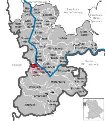
Miltenberg is a Landkreis (district) in Bavaria, Germany. It is bounded by the city of Aschaffenburg, the districts of Aschaffenburg and Main-Spessart, and the states of Baden-Württemberg and Hesse.

<span class="mw-page-title-main">Dammbach</span> Municipality in Bavaria, Germany

Dammbach is a community in the Aschaffenburg district in the Regierungsbezirk of Lower Franconia (Unterfranken) in Bavaria, Germany, and a member of the Verwaltungsgemeinschaft of Mespelbrunn, whose seat is in Heimbuchenthal.

<span class="mw-page-title-main">Obernburg</span> Town in Bavaria, Germany

Obernburg am Main is a town in the Miltenberg district in the Regierungsbezirk of Lower Franconia (Unterfranken) in Bavaria, Germany. It has a population of around 8,500.

<span class="mw-page-title-main">Mittelsinn</span> Municipality in Bavaria, Germany

Mittelsinn is a community in the Main-Spessart district in the Regierungsbezirk of Lower Franconia (Unterfranken) in Bavaria, Germany and a member of the Verwaltungsgemeinschaft of Burgsinn.

<span class="mw-page-title-main">Obersinn</span> Municipality in Bavaria, Germany

Obersinn is a market community in the Main-Spessart district in the Regierungsbezirk of Lower Franconia (Unterfranken) in Bavaria, Germany and a member of the Verwaltungsgemeinschaft of Burgsinn.

<span class="mw-page-title-main">Urspringen</span> Municipality in Bavaria, Germany

Urspringen is a community in the Main-Spessart district in the Regierungsbezirk of Lower Franconia (Unterfranken) in Bavaria, Germany and a member of the Verwaltungsgemeinschaft of Marktheidenfeld.

<span class="mw-page-title-main">Collenberg</span> Municipality in Bavaria, Germany

Collenberg is a community in the Miltenberg district in the Regierungsbezirk of Lower Franconia (Unterfranken) in Bavaria, Germany. It has a population of about 2,400.

<span class="mw-page-title-main">Eichenbühl</span> Municipality in Bavaria, Germany

Eichenbühl is a community in the Miltenberg district in the Regierungsbezirk of Lower Franconia (Unterfranken) in Bavaria, Germany.

<span class="mw-page-title-main">Elsenfeld</span> Municipality in Bavaria, Germany

Elsenfeld is a market community in the Miltenberg district in the Regierungsbezirk of Lower Franconia (Unterfranken) in Bavaria, Germany. It is located on the river Main between the hills of the Spessart, east of the river, and Odenwald, west of the river. Elsenfeld has a total population of around 9,000.

<span class="mw-page-title-main">Eschau</span> Municipality in Bavaria, Germany

Eschau is a market community in the Miltenberg district in the Regierungsbezirk of Lower Franconia (Unterfranken) in Bavaria, Germany. It has a population of around 3,800.

<span class="mw-page-title-main">Faulbach</span> Municipality in Bavaria, Germany

Faulbach is a municipality in the Miltenberg district in the Regierungsbezirk of Lower Franconia (Unterfranken) in Bavaria, Germany. It has a population of around 2,600.

<span class="mw-page-title-main">Hausen, Miltenberg</span> Municipality in Bavaria, Germany

Hausen is a community in the Miltenberg district in the Regierungsbezirk of Lower Franconia (Unterfranken) in Bavaria, Germany and a member of the Verwaltungsgemeinschaft of Kleinwallstadt.

<span class="mw-page-title-main">Kirchzell</span> Municipality in Bavaria, Germany

Kirchzell is a market community in the Miltenberg district in the Regierungsbezirk of Lower Franconia (Unterfranken) in Bavaria, Germany.

<span class="mw-page-title-main">Kleinheubach</span> Municipality in Bavaria, Germany

Kleinheubach is a market community in the Miltenberg district in the Regierungsbezirk of Lower Franconia (Unterfranken) in Bavaria, Germany and the seat of the like-named Verwaltungsgemeinschaft. It has a population of around 3,600.

<span class="mw-page-title-main">Leidersbach</span> Municipality in Bavaria, Germany

Leidersbach is a community in the Miltenberg district in the Regierungsbezirk of Lower Franconia (Unterfranken) in Bavaria, Germany.

<span class="mw-page-title-main">Neunkirchen, Lower Franconia</span> Municipality in Bavaria, Germany

Neunkirchen is a municipality in the Miltenberg district in the Regierungsbezirk of Lower Franconia (Unterfranken) in Bavaria, Germany and a member of the Verwaltungsgemeinschaft of Erftal, whose seat is in Bürgstadt.

<span class="mw-page-title-main">Röllbach</span> Municipality in Bavaria, Germany

Röllbach is a municipality in the Miltenberg district in the Regierungsbezirk of Lower Franconia (Unterfranken) in Bavaria, Germany and a member of the Verwaltungsgemeinschaft of Mönchberg.

<span class="mw-page-title-main">Rüdenau</span> Municipality in Bavaria, Germany

Rüdenau is a municipality in the Miltenberg district in the Regierungsbezirk of Lower Franconia (Unterfranken) in Bavaria, Germany and a member of the Verwaltungsgemeinschaft of Kleinheubach.

<span class="mw-page-title-main">Schneeberg, Bavaria</span> Municipality in Bavaria, Germany

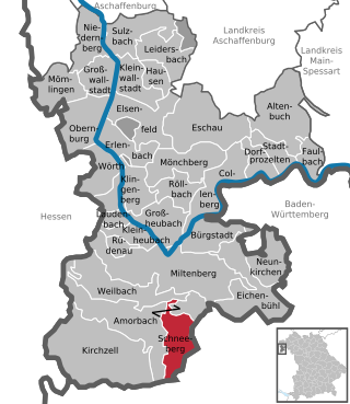
Schneeberg is a market municipality in the Miltenberg district in the Regierungsbezirk of Lower Franconia (Unterfranken) in Bavaria, Germany.

References

  1. Liste der ersten Bürgermeister/Oberbürgermeister in kreisangehörigen Gemeinden, Bayerisches Landesamt für Statistik, 15 July 2021.
  2. "Tabelle 12411-003r Fortschreibung des Bevölkerungsstandes: Gemeinden, Stichtag" (in German). Bayerisches Landesamt für Statistik. June 2022.
  3. Official Website, January 7th 2020 (in German)
  4. Description and explanation of Laudenbach’s arms