Schneeberg, Bavaria

Last updated
Schneeberg
DEU Schneeberg COA.svg
Location of Schneeberg within Miltenberg district
Schneeberg in MIL.svg
Germany adm location map.svg
Red pog.svg
Schneeberg
Bavaria location map.svg
Red pog.svg
Schneeberg
Coordinates: 49°38′22″N09°14′49″E / 49.63944°N 9.24694°E / 49.63944; 9.24694 Coordinates: 49°38′22″N09°14′49″E / 49.63944°N 9.24694°E / 49.63944; 9.24694
Country Germany
State Bavaria
Admin. region Unterfranken
District Miltenberg
Government
   Mayor (202026) Kurt Repp [1] (CSU)
Area
  Total16.60 km2 (6.41 sq mi)
Elevation
168 m (551 ft)
Population
 (2020-12-31) [2]
  Total1,738
  Density100/km2 (270/sq mi)
Time zone UTC+01:00 (CET)
  Summer (DST) UTC+02:00 (CEST)
Postal codes
63936
Dialling codes 09373
Vehicle registration MIL
Website www.schneeberg-odenwald.de

Schneeberg is a market municipality in the Miltenberg district in the Regierungsbezirk of Lower Franconia (Unterfranken) in Bavaria, Germany.

Contents

Geography

Location

Schneeberg lies in the Bavarian Lower Main (Bayerischer Untermain) Region.

The municipality has the following Gemarkungen (traditional rural cadastral areas): Hambrunn, Schneeberg, Zittenfelden.

History

Schneeberg belonged to the Grand Duchy of Hesse-Darmstadt. After the Treaty of Munich in 1816 the place belonged to Bavaria. The Electoral Mainz community was assigned in the 1803 Reichsdeputationshauptschluss to the Princes of Leiningen, was mediatized in 1806 by Baden, and in 1810 was ceded to Hesse-Darmstadt. In the Hesse-Bavaria Rezeß (Frankfurt 1816), it finally passed to Bavaria. In the course of administrative reform in Bavaria, the current municipality came into being with the Gemeindeedikt (“Municipal Edict”) of 1818.

Population development

Within town limits, 1,754 inhabitants were counted in 1970, 1,822 in 1987 and in 2000 1,904.

On 1 January 2006, a figure of 2,009 inhabitants was reported, who represented 17 nationalities, while 1,931 of them were German nationals.

Politics

Mayor

The mayor is Kurt Repp (CSU).

Town council

The council is made up of 12 council members with seats apportioned thus (Election 2020):

Municipal taxes in 1999 amounted to €825,000 (converted), of which net business taxes amounted to €82,000.

Coat of arms

The municipality’s arms might be described thus: Per pale gules a fleur-de-lis argent banded by a crown Or, argent in base a mount of three issuant from which a coniferous tree vert.

The mount of three (a charge called a Dreiberg in German) and the tree symbolize the municipality’s location in the Odenwald (range). The mount itself is also canting for the name element —berg. The lily and the crown are Marian symbols and refer to the pilgrimage known to have been undertaken before 1474 to the “Mother of God on the Elder Trunk” (Muttergottes auf dem Holderstock), the legend underlying which tells of an icon that somehow mysteriously and repeatedly moved from its place in the church to a place on an elder tree.

The arms have been borne since 1968. [3]

Economy and infrastructure

According to official statistics, there were 263 workers on the social welfare contribution rolls working in producing businesses in 1998. In trade and transport this was 0. In other areas, 784 such workers worked from home. There was 1 processing business and 1 construction business, and furthermore, in 1999, there were 18 agricultural operations with a working area of 326 ha, of which 247 ha was meadowland.

Transport

The railway station lies on the Seckach-Miltenberg line (KBS 709), also called the Madonnenlandbahn.

Education

In 1999 the following institutions existed in :

Notable people

Related Research Articles

Miltenberg is a Landkreis (district) in Bavaria, Germany. It is bounded by the city of Aschaffenburg, the districts of Aschaffenburg and Main-Spessart, and the states of Baden-Württemberg and Hesse.

Wattendorf Municipality in Bavaria, Germany

Wattendorf is the smallest community in the Upper Franconian district of Bamberg and a member of the administrative community (Verwaltungsgemeinschaft) of Steinfeld.

Obernburg Town in Bavaria, Germany

Obernburg am Main is a town in the Miltenberg district in the Regierungsbezirk of Lower Franconia (Unterfranken) in Bavaria, Germany. It has a population of around 8,500.

Kleinwallstadt Municipality in Bavaria, Germany

Kleinwallstadt is a market community in the Miltenberg district in the Regierungsbezirk of Lower Franconia (Unterfranken) in Bavaria, Germany and the seat of the like-named Verwaltungsgemeinschaft.

Lauter, Bavaria Municipality in Bavaria, Germany

Lauter is a community in the Upper Franconian district of Bamberg and a member of the administrative community (Verwaltungsgemeinschaft) of Baunach.

Fellen Municipality in Bavaria, Germany

Fellen is a community in the Main-Spessart district in the Regierungsbezirk of Lower Franconia (Unterfranken) in Bavaria, Germany and a member of the Verwaltungsgemeinschaft of Burgsinn.

Karbach, Bavaria Municipality in Bavaria, Germany

Karbach is a market community in the Main-Spessart district in the Regierungsbezirk of Lower Franconia (Unterfranken) in Bavaria, Germany and a member of the Verwaltungsgemeinschaft of Marktheidenfeld.

Retzstadt Municipality in Bavaria, Germany

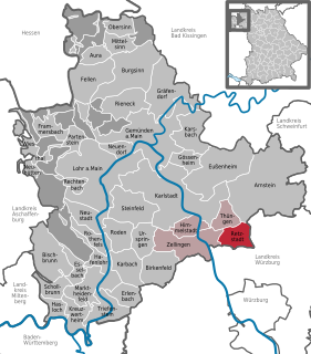
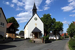
Retzstadt is a community in the Main-Spessart district in the Regierungsbezirk of Lower Franconia (Unterfranken) in Bavaria, Germany and a member of the Verwaltungsgemeinschaft of Zellingen.

Dorfprozelten Municipality in Bavaria, Germany

Dorfprozelten is a municipality in the Miltenberg district in the Regierungsbezirk of Lower Franconia (Unterfranken) in Bavaria, Germany. It is one of the oldest settlements on the Lower Main. Sandstone quarrying was a major industry once. The village has also long been known as the home of people involved in inland (river) navigation. Today, Dorfprozelten has a population of close to 1,800.

Eichenbühl Municipality in Bavaria, Germany

Eichenbühl is a community in the Miltenberg district in the Regierungsbezirk of Lower Franconia (Unterfranken) in Bavaria, Germany.

Eschau Municipality in Bavaria, Germany

Eschau is a market community in the Miltenberg district in the Regierungsbezirk of Lower Franconia (Unterfranken) in Bavaria, Germany. It has a population of around 3,800.

Faulbach Municipality in Bavaria, Germany

Faulbach is a municipality in the Miltenberg district in the Regierungsbezirk of Lower Franconia (Unterfranken) in Bavaria, Germany. It has a population of around 2,600.

Großwallstadt Municipality in Bavaria, Germany

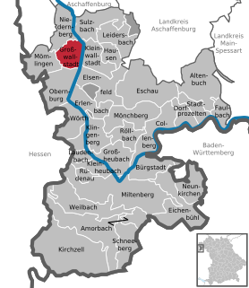
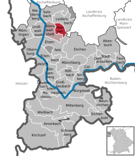
Großwallstadt is a community in the Miltenberg district in the Regierungsbezirk of Lower Franconia (Unterfranken) in Bavaria, Germany.

Hausen, Miltenberg Municipality in Bavaria, Germany

Hausen is a community in the Miltenberg district in the Regierungsbezirk of Lower Franconia (Unterfranken) in Bavaria, Germany and a member of the Verwaltungsgemeinschaft of Kleinwallstadt.

Kirchzell Municipality in Bavaria, Germany

Kirchzell is a market community in the Miltenberg district in the Regierungsbezirk of Lower Franconia (Unterfranken) in Bavaria, Germany.

Kleinheubach Municipality in Bavaria, Germany

Kleinheubach is a market community in the Miltenberg district in the Regierungsbezirk of Lower Franconia (Unterfranken) in Bavaria, Germany and the seat of the like-named Verwaltungsgemeinschaft. It has a population of around 3,600.

Laudenbach, Bavaria Municipality in Bavaria, Germany

For other places with the same name, see Laudenbach (disambiguation)

Röllbach Municipality in Bavaria, Germany

Röllbach is a municipality in the Miltenberg district in the Regierungsbezirk of Lower Franconia (Unterfranken) in Bavaria, Germany and a member of the Verwaltungsgemeinschaft of Mönchberg.

Rüdenau Municipality in Bavaria, Germany

Rüdenau is a municipality in the Miltenberg district in the Regierungsbezirk of Lower Franconia (Unterfranken) in Bavaria, Germany and a member of the Verwaltungsgemeinschaft of Kleinheubach.

Weilbach, Germany Municipality in Bavaria, Germany

Weilbach is a market municipality in the Miltenberg district in the Regierungsbezirk of Lower Franconia (Unterfranken) in Bavaria, Germany.

References

  1. Liste der ersten Bürgermeister/Oberbürgermeister in kreisangehörigen Gemeinden, Bayerisches Landesamt für Statistik, 15 July 2021.
  2. "Tabellenblatt "Daten 2", Statistischer Bericht A1200C 202041 Einwohnerzahlen der Gemeinden, Kreise und Regierungsbezirke". Bayerisches Landesamt für Statistik (in German). June 2021.
  3. Description and explanation of Schneeberg’s arms