Dorfprozelten

Last updated
Dorfprozelten
Bayern Dorfprozelten am Main mit Magna Mirrors Gmbh from north IMG 8261.JPG
Aerial picture of Dorfprozelten from the north
DEU Dorfprozelten COA.svg
Location of Dorfprozelten within Miltenberg district
Dorfprozelten in MIL.svgHohe Wart (unincorporated area)ForstwaldHohe BergWeilbachSchneebergNeunkirchenLaudenbachHausen
Germany adm location map.svg
Red pog.svg
Dorfprozelten
Bavaria location map.svg
Red pog.svg
Dorfprozelten
Coordinates: 49°47′N9°23′E / 49.783°N 9.383°E / 49.783; 9.383
Country Germany
State Bavaria
Admin. region Unterfranken
District Miltenberg
Government
   Mayor (202026) Lisa Steger [1] (CSU)
Area
  Total
10.39 km2 (4.01 sq mi)
Elevation
141 m (463 ft)
Population
 (2023-12-31) [2]
  Total
1,721
  Density170/km2 (430/sq mi)
Time zone UTC+01:00 (CET)
  Summer (DST) UTC+02:00 (CEST)
Postal codes
97904
Dialling codes 09392
Vehicle registration MIL
Website www.dorfprozelten.de

Dorfprozelten is a municipality in the Miltenberg district in the Regierungsbezirk of Lower Franconia (Unterfranken) in Bavaria, Germany. It is one of the oldest settlements on the Lower Main. Sandstone quarrying was a major industry once. The village has also long been known as the home of people involved in inland (river) navigation. Today, Dorfprozelten has a population of close to 1,800.

Contents

Geography

Location

Dorfprozelten lies on the right bank of the river Main between Miltenberg and Wertheim on the southern edge of the Mittelgebirge Spessart.

Subdivisions

The community has only the Gemarkung (traditional rural cadastral area) of Dorfprozelten.

Neighbouring communities

Dorfprozelten borders on (clockwise from the north): Eschau, Stadtprozelten, Wertheim (Baden-Württemberg), Freudenberg (Baden-Württemberg) and Collenberg.

History

St. Vitus, Romanesque Revival church Dorfprozelten, St. Vitus-001.jpg
St. Vitus, Romanesque Revival church

A church was built here in 1009 by Willigis, Archbishop of Mainz. [3] :65 In 1012, Dorfprozelten had its first documentary mention under the name Brotselden or Bradselden. There are various explanations for the name's origin.

Previously ruled by the Archbishop of Mainz, with the 1803 Reichsdeputationshauptschluss Dorfprozelten became a part of Prince Primate von Dalberg's newly formed Principality of Aschaffenburg, with which it passed in 1814 (by this time it had become a department of the Grand Duchy of Frankfurt) to the Kingdom of Bavaria.

In the course of administrative reform in Bavaria, the current community came into being with the Gemeindeedikt ("Municipal Edict") of 1818.

Demographics

Within town limits, 1,627 inhabitants were counted in 1970, 1,741 in 1987 and in 2000 1,972.

Economy

Until the 1970s, the community was home to a substantial sandstone industry. Dorfprozelten stonemasons took part in building, among other projects, the Hermitage in Saint Petersburg, Mainz Cathedral and the Reichstag. Sandstone quarrying also supported the local shipping industry, which for a time made Dorfprozelten Germany's inland port village.

Today, Dorfprozelten is home to various branches of industry. Among others, a big car component manufacturer has settled here. On the slopes of the Main, in the Dorfprozeltener Predigtstuhl vineyard, Franconian wine is grown.

According to official statistics, there were 192 workers on the social welfare contribution rolls working in producing businesses in 1998. In trade and transport this was 0. In other areas, 54 workers on the social welfare contribution rolls were employed, and 717 such workers worked from home. There were 9 processing businesses. Two businesses were in construction, and furthermore, in 1999, there were 5 agricultural operations with a working area of 17 ha.

Municipal taxes in 1999 amounted to €987,000 (converted), of which net business taxes amounted to €123,000.

Governance

The mayor is Lisa Steger (CSU), elected in March 2020. [1]

Coat of arms

The community’s arms might be described thus: Per fess gules a wheel spoked of six argent and argent a cross sable, a base wavy of three azure.

The black cross on a silver background is the coat of arms once borne by the Teutonic Knights, who are known to have been in the municipal area about 1260. About 1319 or 1320, the Knights acquired Prozelten Castle and the community of Dorfprozelten, then also known as Niederprozelten or Altprozelten (Dorf means “village” in German, while Nieder means “lower” and Alt “old”). The Teutonic Knights held the lordship over Dorfprozelten, and the Vogtei . These, however, were traded to Electoral Mainz in 1484 until the Old Empire was dissolved in 1803. The six-spoked wheel and the tinctures argent and gules (silver and red) refer to Mainz’s former overlordship. The wavy blue base symbolizes the Main and also the shipping that has been important since days of yore, above all in connection with wood transport from the Spessart.

The arms have been borne since 1954. [4]

Arts and culture

Steel engraving of Collenburg, 1847 Collenberg 1847.jpg
Steel engraving of Collenburg, 1847

The Collenburg  [ de ], a ruined castle, is located just inside the municipal territory.

See also list of monuments at Dorfprozelten (German)

Education

In 1999 the following institutions existed in Dorfprozelten:

Further reading

Related Research Articles

Miltenberg is a Landkreis (district) in Bavaria, Germany. It is bounded by the city of Aschaffenburg, the districts of Aschaffenburg and Main-Spessart, and the states of Baden-Württemberg and Hesse.

<span class="mw-page-title-main">Stadtprozelten</span> Town in Bavaria, Germany

Stadtprozelten is a town and municipality in the Miltenberg district in the Regierungsbezirk of Lower Franconia (Unterfranken) in Bavaria, Germany and the seat of the Verwaltungsgemeinschaft of Stadtprozelten.

<span class="mw-page-title-main">Heimbuchenthal</span> Municipality in Bavaria, Germany

Heimbuchenthal is a community in the Aschaffenburg district in the Regierungsbezirk of Lower Franconia (Unterfranken) in Bavaria, Germany, and the seat of the Verwaltungsgemeinschaft of Mespelbrunn. It is also a state-recognized recreational resort (Erholungsort).

<span class="mw-page-title-main">Kleinostheim</span> Municipality in Bavaria, Germany

Kleinostheim is a community in the Aschaffenburg district in the Regierungsbezirk of Lower Franconia (Unterfranken) in Bavaria, Germany.

<span class="mw-page-title-main">Sommerkahl</span> Municipality in Bavaria, Germany

Sommerkahl is a community in the Aschaffenburg district in the Regierungsbezirk of Lower Franconia (Unterfranken) in Bavaria, Germany and a member of the Verwaltungsgemeinschaft of Schöllkrippen. It has a population of around 1,300 (2020).

<span class="mw-page-title-main">Aura im Sinngrund</span> Municipality in Bavaria, Germany

Aura im Sinngrund is a community in the Main-Spessart district in the Regierungsbezirk of Lower Franconia (Unterfranken) in Bavaria, Germany and a member of the Verwaltungsgemeinschaft of Burgsinn.

<span class="mw-page-title-main">Neuhütten</span> Municipality in Bavaria, Germany

Neuhütten is a place in the Main-Spessart district in the Regierungsbezirk of Lower Franconia (Unterfranken) in Bavaria, Germany and a member of the Verwaltungsgemeinschaft of Partenstein. It has a population of around 1,100.

<span class="mw-page-title-main">Neustadt am Main</span> Municipality in Bavaria, Germany

Neustadt am Main is a community in the Main-Spessart district in the Regierungsbezirk of Lower Franconia (Unterfranken) in Bavaria, Germany and a member of the Verwaltungsgemeinschaft Lohr am Main.

<span class="mw-page-title-main">Triefenstein</span> Municipality in Bavaria, Germany

Markt Triefenstein is a market community in the Main-Spessart district in the Regierungsbezirk of Lower Franconia (Unterfranken) in Bavaria, Germany. It was created in 1978 out of the villages Homburg am Main, Lengfurt, Rettersheim and Trennfeld.

<span class="mw-page-title-main">Altenbuch</span> Municipality in Bavaria, Germany

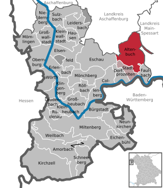
Altenbuch is a community in the Miltenberg district in the Regierungsbezirk of Lower Franconia (Unterfranken) in Bavaria, Germany and a member of the Verwaltungsgemeinschaft of Stadtprozelten. Altenbuch has around 1,200 inhabitants.

<span class="mw-page-title-main">Bürgstadt</span> Municipality in Bavaria, Germany

Bürgstadt is a market community in the Miltenberg district in the Regierungsbezirk of Lower Franconia (Unterfranken) in Bavaria, Germany and the seat of the Verwaltungsgemeinschaft of Erftal. Bürgstadt is a winegrowing community in the wine region of Franken. It has a population of around 4,300.

<span class="mw-page-title-main">Collenberg</span> Municipality in Bavaria, Germany

Collenberg is a community in the Miltenberg district in the Regierungsbezirk of Lower Franconia (Unterfranken) in Bavaria, Germany. It has a population of about 2,400.

<span class="mw-page-title-main">Elsenfeld</span> Municipality in Bavaria, Germany

Elsenfeld is a market community in the Miltenberg district in the Regierungsbezirk of Lower Franconia (Unterfranken) in Bavaria, Germany. It is located on the river Main between the hills of the Spessart, east of the river, and Odenwald, west of the river. Elsenfeld has a total population of around 9,000.

<span class="mw-page-title-main">Faulbach</span> Municipality in Bavaria, Germany

Faulbach is a municipality in the Miltenberg district in the Regierungsbezirk of Lower Franconia (Unterfranken) in Bavaria, Germany. It has a population of around 2,600.

<span class="mw-page-title-main">Großheubach</span> Municipality in Bavaria, Germany

Großheubach is a market community in the Miltenberg district in the Regierungsbezirk of Lower Franconia (Unterfranken) in Bavaria, Germany.

<span class="mw-page-title-main">Kleinheubach</span> Municipality in Bavaria, Germany

Kleinheubach is a market community in the Miltenberg district in the Regierungsbezirk of Lower Franconia (Unterfranken) in Bavaria, Germany and the seat of the like-named Verwaltungsgemeinschaft. As of the 2011 census, it has a population of around 3,614.

<span class="mw-page-title-main">Mönchberg</span> Municipality in Bavaria, Germany

Mönchberg is a market community in the Miltenberg district in the Regierungsbezirk of Lower Franconia (Unterfranken) in Bavaria, Germany. It is the seat of the Verwaltungsgemeinschaft of Mönchberg and a state-recognized climatic spa (Luftkurort).

<span class="mw-page-title-main">Neunkirchen, Lower Franconia</span> Municipality in Bavaria, Germany

Neunkirchen is a municipality in the Miltenberg district in the Regierungsbezirk of Lower Franconia in Bavaria, Germany and a member of the Verwaltungsgemeinschaft of Erftal, whose seat is in Bürgstadt.

<span class="mw-page-title-main">Rüdenau</span> Municipality in Bavaria, Germany

Rüdenau is a municipality in the Miltenberg district in the Regierungsbezirk of Lower Franconia (Unterfranken) in Bavaria, Germany and a member of the Verwaltungsgemeinschaft of Kleinheubach.

<span class="mw-page-title-main">Sulzbach am Main</span> Municipality in Bavaria, Germany

Sulzbach am Main is a market municipality in the Miltenberg district in the Regierungsbezirk of Lower Franconia (Unterfranken) in Bavaria, Germany.

References

  1. 1 2 Liste der ersten Bürgermeister/Oberbürgermeister in kreisangehörigen Gemeinden, Bayerisches Landesamt für Statistik, 15 July 2021.
  2. Genesis Online-Datenbank des Bayerischen Landesamtes für Statistik Tabelle 12411-003r Fortschreibung des Bevölkerungsstandes: Gemeinden, Stichtag (Einwohnerzahlen auf Grundlage des Zensus 2011).
  3. Thiemig, Karl, ed. (1972). Grieben Reiseführer, Band 137: Spessart (German). Grieben Verlag, München.
  4. Description and explanation of Dorfprozelten’s arms [ permanent dead link ]