
Dorset is a county in South West England on the English Channel coast. Covering an area of 2,653 square kilometres (1,024 sq mi); it borders Devon to the west, Somerset to the north-west, Wiltshire to the north-east, and Hampshire to the east. The great variation in its landscape owes much to the underlying geology, which includes an almost unbroken sequence of rocks from 200 to 40 million years ago (Mya) and superficial deposits from 2 Mya to the present. In general, the oldest rocks appear in the far west of the county, with the most recent (Eocene) in the far east. Jurassic rocks also underlie the Blackmore Vale and comprise much of the coastal cliff in the west and south of the county; although younger Cretaceous rocks crown some of the highpoints in the west, they are mainly to be found in the centre and east of the county.

The Rhine-Neckar Metropolitan Region, often referred to as Rhein-Neckar-Triangle, is a polycentric metropolitan region located in south western Germany, between the Frankfurt/Rhine-Main region to the North and the Stuttgart Region to the South-East.

Dillingen is a town in the district of Saarlouis, in Saarland. It has about 20,000 inhabitants and is divided into the three districts Dillingen-city center, Pachten and Diefflen. The city is located on the edge of the Saar-Hunsrück Nature Park at the mouth of the Prims in the Saar and is located about 10 km from the French border. Dillingen is located about 60 km from Luxembourg City and Trier, 50 km from Metz and 30 km from Saarbrücken and is directly adjacent to the urban area of Saarlouis. In terms of population, it is the second largest municipality in the district of Saarlouis. The Dillinger Hütte steelworks is located here.
In geology, the term Torridonian is the informal name for the Torridonian Group, a series of Mesoproterozoic to Neoproterozoic arenaceous and argillaceous sedimentary rocks, which occur extensively in the Northwest Highlands of Scotland. The strata of the Torridonian Group are particularly well exposed in the district of upper Loch Torridon, a circumstance which suggested the name Torridon Sandstone, first applied to these rocks by James Nicol. Stratigraphically, they lie unconformably on gneisses of the Lewisian complex and their outcrop extent is restricted to the Hebridean Terrane.
The Keuper is a lithostratigraphic unit in the subsurface of large parts of west and central Europe. The Keuper consists of dolomite, shales or claystones and evaporites that were deposited during the Middle and Late Triassic epochs. The Keuper lies on top of the Muschelkalk and under the predominantly Lower Jurassic Lias or other Early Jurassic strata.

The Palatinate Forest, sometimes also called the Palatine Forest, is a low-mountain region in southwestern Germany, located in the Palatinate in the state of Rhineland-Palatinate. The forest is a designated nature park covering 1,771 km2 and its highest elevation is the Kalmit.
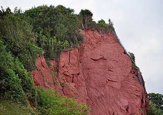
The New Red Sandstone, chiefly in British geology, is composed of beds of red sandstone and associated rocks laid down throughout the Permian to the end of the Triassic, that underlie the Jurassic-Triassic age Penarth Group. The name distinguishes it from the Old Red Sandstone which is largely Devonian in age, and with which it was originally confused due to their similar composition.

Otzberg is a municipality in the district of Darmstadt-Dieburg, located in the Odenwald forest region of Germany. It was founded in 1972 by the merger of six former independent municipalities.
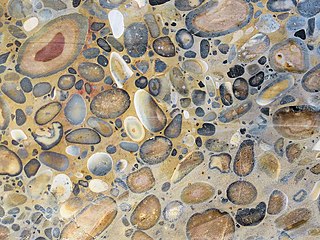
Puddingstone, also known as either pudding stone or plum-pudding stone, is a popular name applied to a conglomerate that consists of distinctly rounded pebbles whose colours contrast sharply with the colour of the finer-grained, often sandy, matrix or cement surrounding them. The rounded pebbles and the sharp contrast in colour gives this type of conglomerate the appearance of a raisin or Christmas pudding. There are different types of puddingstone, with different composition, origin, and geographical distribution. Examples of different types of puddingstones include the Hertfordshire, Schunemunk, Roxbury, and St. Joseph Island puddingstones.

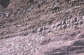
One of the classic locations for the study of Triassic sandstones in the UK is at Alderley Edge in Cheshire. Numerous scientists from the early 19th century up to the present day have studied the area and it is a popular field site for universities around the UK.

Abtweiler is an Ortsgemeinde – a municipality belonging to a Verbandsgemeinde, a kind of collective municipality – in the Bad Kreuznach district in Rhineland-Palatinate, Germany. It belongs to the Verbandsgemeinde of Meisenheim, whose seat is in the like-named town.
The Germanic Trias Supergroup is a lithostratigraphic unit in the subsurface of large parts of western and central Europe and the North Sea. Almost all of the Germanic Trias was deposited during the Triassic period and consists of three clearly different units: Buntsandstein, Muschelkalk and Keuper, that gave the period its name. In the past the names of these three units were also used as units in the geologic timescale, but in modern literature they only have a lithostratigraphic meaning.
The Buntsandstein or Bunter sandstone is a lithostratigraphic and allostratigraphic unit in the subsurface of large parts of west and central Europe. The Buntsandstein predominantly consists of sandstone layers of the Lower Triassic series and is one of three characteristic Triassic units, together with the Muschelkalk and Keuper that form the Germanic Trias Supergroup.
The Enon Formation is a geological formation found in the Eastern and Western Cape provinces in South Africa. It is the lowermost of the four formations found within the Uitenhage Group of the Algoa Basin, its type locality, where it has been measured at a maximum thickness of 480 metres (1,570 ft). Discontinuous outcrops are also found in the Worcester-Pletmos and Oudshoorn-Gamtoos Basins, including isolated occurrences in the Haasvlakte, Jubilee, and Soutpansvlakte Basins near the small town Bredasdorp.
Igneous rocks are found in Bukit Timah, Woodlands, and Pulau Ubin island. Granite makes up the bulk of the igneous rock. Gabbro is also found in the area and is found in an area called Little Guilin, named for its resemblance to Guilin in South China. This area is in Bukit Gombak. Sedimentary rocks are found on the western part of Singapore, which is mainly made of sandstone and mudstones. It also includes the southwestern area. Metamorphic rocks are found in the northeastern part of Singapore, and also on Pulau Tekong, off the east coast of Singapore. The rocks are mainly made up of quartzite, and also make up the Sajahat Formation.

The Sherwood Sandstone Group is a Triassic lithostratigraphic group which is widespread in Britain, especially in the English Midlands. The name is derived from Sherwood Forest in Nottinghamshire which is underlain by rocks of this age. It has economic importance as the reservoir of the Morecambe Bay gas field, the second largest gas field in the UK.

The Shinumo Quartzite also known as the Shinumo Sandstone, is a Mesoproterozoic rock formation, which outcrops in the eastern Grand Canyon, Coconino County, Arizona,. It is the 3rd member of the 5-unit Unkar Group. The Shinumo Quartzite consists of a series of massive, cliff-forming sandstones and sedimentary quartzites. Its cliffs contrast sharply with the stair-stepped topography of typically brightly-colored strata of the underlying slope-forming Hakatai Shale. Overlying the Shinumo, dark green to black, fissile, slope-forming shales of the Dox Formation create a well-defined notch. It and other formations of the Unkar Group occur as isolated fault-bound remnants along the main stem of the Colorado River and its tributaries in Grand Canyon.
Typically, the Shinumo Quartzite and associated strata of the Unkar Group dip northeast (10°–30°) toward normal faults that dip 60+° toward the southwest. This can be seen at the Palisades fault in the eastern part of the main Unkar Group outcrop area.

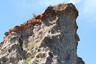
The Devil's Table in Hinterweidenthal is a 14 metre high mushroom rock in the German part of the Wasgau region, the southern Palatine Forest in the state of Rhineland-Palatinate). Thanks to its location in the territory of the village of Kaltenbach - formerly part of Wilgartswiesen – it is often called the Kaltenbach Devil's Table, especially in old literary sources. It is larger and better known than the Devil's Table of Salzwoog, which is only 5 kilometres away to the southwest.
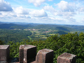
The Wasgau is a Franco-German hill range in the German state of Rhineland-Palatinate and the French departments of Bas-Rhin and Moselle. It is formed from the southern part of the Palatine Forest and the northern part of the Vosges mountains, and extends from the River Queich in the north over the French border to the Col de Saverne in the south.

The geology of Germany is heavily influenced by several phases of orogeny in the Paleozoic and the Cenozoic, by sedimentation in shelf seas and epicontinental seas and on plains in the Permian and Mesozoic as well as by the Quaternary glaciations.