Goldbach, Bavaria

Last updated
Goldbach
Goldbach with St. Nikolaus.jpg
Goldbach with the Church of Saint Nicholas
Wappen von Goldbach (Unterfranken).svg
Coat of arms
Location of Goldbach within Aschaffenburg district
Goldbach in AB.svg
Germany adm location map.svg
Red pog.svg
Goldbach
Bavaria location map.svg
Red pog.svg
Goldbach
Coordinates: 49°59′20″N09°11′11″E / 49.98889°N 9.18639°E / 49.98889; 9.18639 Coordinates: 49°59′20″N09°11′11″E / 49.98889°N 9.18639°E / 49.98889; 9.18639
Country Germany
State Bavaria
Admin. region Unterfranken
District Aschaffenburg
Government
   Mayor (202026) Sandra Rußmann [1]
Area
  Total10.97 km2 (4.24 sq mi)
Elevation
148 m (486 ft)
Population
 (2020-12-31) [2]
  Total10,092
  Density920/km2 (2,400/sq mi)
Time zone UTC+01:00 (CET)
  Summer (DST) UTC+02:00 (CEST)
Postal codes
63773
Dialling codes 06021
Vehicle registration AB
Website markt-goldbach.de
Markt Goldbach, sculpture Tussen Unterafferbach en Goldbach, sculptuur foto5 2016-08-09 10.09.jpg
Markt Goldbach, sculpture

Goldbach is a market community in the Aschaffenburg district in the Regierungsbezirk of Lower Franconia (Unterfranken) in Bavaria, Germany.

Contents

Geography

Location

Constituent communities Markt Goldbach.svg
Constituent communities

The market community is one of the most heavily populated communities in the Aschaffenburg district and is well known for the “housing” that encloses the Autobahn A 3. It is believed that the name has its roots in the yellow loess soil, which during heavy rainfalls colours the local brook, also called the Goldbach, with a somewhat golden tinge. Gold is also the German word for gold, and Bach means “brook”. Supposedly, the place was first called Gelbbach, gelb being the word for “yellow”.

Constituent communities

On 1 July 1971, the formerly self-administering community of Unterafferbach was amalgamated with Goldbach.

History

In 1218, Goldbach had its first documentary mention. From the mid 15th century, Goldbach was under the authority of the Archbishop of Mainz. In 1814, Goldbach was transferred to Bavaria. On 26 May 1995, Goldbach was granted the designation Markt (“Market”).

Politics

Community council

The council is made up of 24 council members, not counting the mayor.

CSU SPD FWG Total
2008921324 seats

(as at municipal election held on 2 March 2008)

Coat of arms

The community’s arms might be described thus: Gules a bend wavy Or, in chief a noble coronet argent set with colourful stones, in base a wheel spoked of six of the third.

The German blazon describes the coronet as a Laubkrone, or “leaf crown”.

The “bend wavy Or” – that is to say, wavy slanted golden stripe – is canting. As explained above, the community’s name means “Gold Brook”, and this bend is a visual representation of just such a thing. From the 7th to the 11th century, Goldbach belonged to the area of the Frankish royal estate, which is what the crown symbolizes. Until 1803, Goldbach found itself under Electoral Mainz hegemony, a fact recalled by the Wheel of Mainz on the other side of the bend. The tinctures Or and gules (gold and red) are taken from the arms once borne by the Counts of Rieneck, who until they died out in 1559 held the Vogtei as the vassals of the Archbishop of Mainz.

The arms have been borne since 1965.

Town partnerships

Culture and sightseeing

Churches

Goldbach has two Catholic parish churches. The alte Kirche (“old church”), as Saint Nicholas’s Church (St. Nikolaus-Kirche) is called, is found in the old village centre. The sandstone Romanesque Revival church that exists today was built in 1894 and 1895 on the spot where once there was an older building that had become too small. The newer church was later enlarged by adding a modern annex.

In the west of the community, which at the time was a new development area, the modern church St. Maria Immaculata was consecrated in 1961, as Saint Nicholas’s had itself become too small to accommodate the community’s growing numbers. The plain clinker-brick building with a 37 m-tall asymmetrical tower seats 600. The chancel is graced by a monumental painting by the artist Curd Lessig as well as by a modern octagonal altar lamp whose ornate glass panes depicts Biblical scenes. One peculiarity of the church is its organ threesome. Besides the main organ with its 36 speaking stops, built in 1964 by the organ building firm Michael Weise, the church also has at its disposal a Baroque organ from 1782 that was thoroughly restored in the early 1980s and a positive organ from Hartwig Späth’s workshop.

At community limits with Hösbach, the Evangelical Johanneskirche (“Saint John’s Church”) is situated.

Sport and clubs

In Goldbach there is a lively sport, culture and club life. Drawing attention from well beyond the region is the Winterlaufserie (“Winter Run Series”), carried on TV Goldbach, which is said to cover 10 km on each of nine appointed times.

Further clubs are VfR Goldbach, AC Bavaria Goldbach, Gesangverein Harmonie Goldbach (singing club), Gesangverein Sängerkranz Goldbach (singing club), KJG St. Nikolaus, KJG St. Maria Immaculata, DJK Goldbach 1985 e.V., MSC Goldbach, KKS Goldbach, BRK Goldbach, Freiwillige Feuerwehr Goldbach (volunteer fire brigade), RG Goldbach, F.W.V. Goldbach.

Economy and infrastructure

Transport

Goldbach lies right on the A 3 between Frankfurt (roughly 45 km away) and Würzburg (roughly 75 km away). Between Goldbach and Hösbach, when the Autobahn was being widened to six lanes, a “housing” was built over the roadway to reduce the noise pollution.

Public institutions

On the way out of the community, going towards Unterafferbach, is a forest swimming pool. The indoor swimming pool at the elementary school is open to the public in the winter months. Throughout the community are 10 playgrounds, 3 football pitches and 2 sport halls.

Related Research Articles

Aschaffenburg is a Landkreis (district) in Bavaria, Germany. It is bounded by the districts of Darmstadt-Dieburg, Offenbach, Main-Kinzig, the districts Main-Spessart and Miltenberg, and the town of Aschaffenburg.

Hösbach Place in Bavaria, Germany

Hösbach is a market community and municipality in the Aschaffenburg district in the Regierungsbezirk of Lower Franconia (Unterfranken) in Bavaria, Germany. It has a population of around 13,000 (2020).

Schöllkrippen Place in Bavaria, Germany

Schöllkrippen is a market community in the Aschaffenburg district in the Regierungsbezirk of Lower Franconia (Unterfranken) in Bavaria, Germany and seat of the Verwaltungsgemeinschaft of Schöllkrippen. It has a total population of around 4,300 (2020).

Dammbach Place in Bavaria, Germany

Dammbach is a community in the Aschaffenburg district in the Regierungsbezirk of Lower Franconia (Unterfranken) in Bavaria, Germany, and a member of the Verwaltungsgemeinschaft of Mespelbrunn, whose seat is in Heimbuchenthal.

Kahl am Main Place in Bavaria, Germany

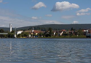
Kahl am Main is a community in the Aschaffenburg district in the Regierungsbezirk of Lower Franconia (Unterfranken) in Bavaria, Germany. It has around 7,500 inhabitants.

Blankenbach Place in Bavaria, Germany

Blankenbach is a community in the Aschaffenburg district in the Regierungsbezirk of Lower Franconia (Unterfranken) in Bavaria, Germany, and a member of the Verwaltungsgemeinschaft of Schöllkrippen.

Glattbach Place in Bavaria, Germany

Glattbach is a community in the Aschaffenburg district in the Regierungsbezirk of Lower Franconia (Unterfranken) in Bavaria, Germany. It has around 3,300 inhabitants (2020).

Haibach, Lower Franconia Place in Bavaria, Germany

Haibach is a community in the Aschaffenburg district in the Regierungsbezirk of Lower Franconia (Unterfranken) in Bavaria, Germany. It has a population of around 8,300.

Heimbuchenthal Place in Bavaria, Germany

Heimbuchenthal is a community in the Aschaffenburg district in the Regierungsbezirk of Lower Franconia (Unterfranken) in Bavaria, Germany, and the seat of the Verwaltungsgemeinschaft of Mespelbrunn. It is also a state-recognized recreational resort (Erholungsort).

Johannesberg, Bavaria Place in Bavaria, Germany

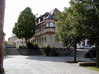
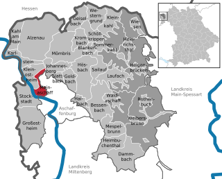
Johannesberg is a community in the Aschaffenburg district in the Regierungsbezirk of Lower Franconia (Unterfranken) in Bavaria, Germany. It has around 3,900 inhabitants.

Kleinkahl Place in Bavaria, Germany

Kleinkahl is a community in the Aschaffenburg district in the Regierungsbezirk of Lower Franconia (Unterfranken) in Bavaria, Germany, and a member of the Verwaltungsgemeinschaft of Schöllkrippen. Kleinkahl has around 1,800 inhabitants.

Kleinostheim Place in Bavaria, Germany

Kleinostheim is a community in the Aschaffenburg district in the Regierungsbezirk of Lower Franconia (Unterfranken) in Bavaria, Germany.

Mainaschaff Place in Bavaria, Germany

Mainaschaff is a community in the Aschaffenburg district in the Regierungsbezirk of Lower Franconia (Unterfranken) in Bavaria, Germany. It has a population of around 9,000 (2020).

Sailauf Place in Bavaria, Germany

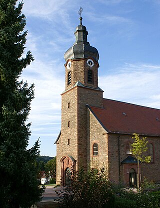
Sailauf is a municipality in the Aschaffenburg district in the Regierungsbezirk of Lower Franconia (Unterfranken) in Bavaria, Germany. It has a population of around 3,600.

Sommerkahl Place in Bavaria, Germany

Sommerkahl is a community in the Aschaffenburg district in the Regierungsbezirk of Lower Franconia (Unterfranken) in Bavaria, Germany and a member of the Verwaltungsgemeinschaft of Schöllkrippen. It has a population of around 1,300 (2020).

Waldaschaff Place in Bavaria, Germany

Waldaschaff is a community in the Aschaffenburg district in the Regierungsbezirk of Lower Franconia (Unterfranken) in Bavaria, Germany.

Wiesen, Bavaria Place in Bavaria, Germany

Wiesen is a community in the Aschaffenburg district in the Regierungsbezirk of Lower Franconia (Unterfranken) in Bavaria, Germany and a member of the Verwaltungsgemeinschaft of Schöllkrippen. It has around 1,000 inhabitants.
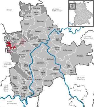
Gerach Place in Bavaria, Germany

Gerach is a community in the Upper Franconian district of Bamberg and a member of the administrative community (Verwaltungsgemeinschaft) of Baunach. It lies in the Naturpark Haßberge roughly 20 km north of Bamberg and roughly 10 km south of Ebern.

Faulbach Place in Bavaria, Germany

Faulbach is a municipality in the Miltenberg district in the Regierungsbezirk of Lower Franconia (Unterfranken) in Bavaria, Germany. It has a population of around 2,600.

Rüdenau Place in Bavaria, Germany

Rüdenau is a municipality in the Miltenberg district in the Regierungsbezirk of Lower Franconia (Unterfranken) in Bavaria, Germany and a member of the Verwaltungsgemeinschaft of Kleinheubach.

References

  1. Liste der ersten Bürgermeister/Oberbürgermeister in kreisangehörigen Gemeinden, Bayerisches Landesamt für Statistik, 15 July 2021.
  2. "Tabellenblatt "Daten 2", Statistischer Bericht A1200C 202041 Einwohnerzahlen der Gemeinden, Kreise und Regierungsbezirke". Bayerisches Landesamt für Statistik und Datenverarbeitung (in German). June 2021.