Rothenbuch

Last updated
Rothenbuch
Schloss Rothenbuch.JPG
Rothenbuch Palace
DEU Rothenbuch COA.svg
Location of Rothenbuch within Aschaffenburg district
Rothenbuch in AB.svgJohannesbergWiesener ForstForst Hain im SpessartHeinrichsthaler ForstHeinrichsthaler ForstWaldaschaffer ForstSchöllkrippener ForstSailaufer ForstRohrbrunner ForstRothenbucher ForstGoldbachWiesenKrombachHaibach
Germany adm location map.svg
Red pog.svg
Rothenbuch
Bavaria location map.svg
Red pog.svg
Rothenbuch
Coordinates: 49°58′N9°24′E / 49.967°N 9.400°E / 49.967; 9.400 Coordinates: 49°58′N9°24′E / 49.967°N 9.400°E / 49.967; 9.400
Country Germany
State Bavaria
Admin. region Unterfranken
District Aschaffenburg
Government
   Mayor (202026) Markus Fäth [1] (SPD)
Area
  Total7.05 km2 (2.72 sq mi)
Elevation
365 m (1,198 ft)
Population
 (2021-12-31) [2]
  Total1,759
  Density250/km2 (650/sq mi)
Time zone UTC+01:00 (CET)
  Summer (DST) UTC+02:00 (CEST)
Postal codes
63860
Dialling codes 06094
Vehicle registration AB
Website www.rothenbuch.de

Rothenbuch is a community in the Aschaffenburg district in the Regierungsbezirk of Lower Franconia (Unterfranken) in Bavaria, Germany. It has a population of around 1,700.

Contents

Geography

Location

Rothenbuch lies in the region Bayerischer Untermain (Bavarian Lower Main), in Germany's largest consecutive broadleaf woodland, the Spessart. Rothenbuch is located between the Frankfurt Rhine Main Region, centred on Frankfurt, and the Würzburg region. The nearest international airport is Frankfurt Airport and the nearest InterCityExpress stop is the railway station at Aschaffenburg.

History

In 1318, Rothenbuch had its first documentary mention in the words zuo den Rodenboychen when the Archbishop of Mainz, Peter of Aspelt and the Bishop of Würzburg, Gottfried III of Hohenlohe, concluded an agreement here dealing with cooperation on security questions.

In 1342, building work began on what was initially likely a hunting lodge at the source of the Hafenlohr. In the German Peasants' War in 1525, this Schloss (castle) in Rothenbuch was heavily damaged or destroyed. In 1566, it was not only rebuilt but also expanded on Elector of Mainz Daniel Brendel von Homburg’s orders.

A first drawing of Rothenbuch is to be found on the oldest extant map of the Spessart, the so-called Pfinzigkarte from 1594.

Rothenbuch achieved its greatest political importance when the Amtskellerei Rothenbuch, a financial and administrative authority for 14 places in the High Spessart, was established. In 1782, Rothenbuch was declared the seat of the Amtsvogtei .

The Electoral Mainz Amt passed along with this under the 1803 Reichsdeputationshauptschluss to the newly formed Principality of Aschaffenburg, with which it passed in 1814 (by this time it had become a department of the Grand Duchy of Frankfurt) to the Kingdom of Bavaria.

On 3 June 1814, Rothenbuch became the seat of a Royal Bavarian Court. In 1879, the Court was dissolved and Rothenbuch was incorporated into the Bezirksamt and later District (Landkreis) of Lohr. In 1972, this district was abolished and Rothenbuch was grouped into the current Aschaffenburg district. From 1977 to 1993, Rothenbuch, along with Waldaschaff and Weibersbrunn, formed a Verwaltungsgemeinschaft (municipal association). On 1 January 1994, Rothenbuch regained its municipal autonomy.

Demographics

Within the municipal area, 993 inhabitants were counted in 1900, 1,476 in 1950 and 1,975 in 2007.

Economy

Municipal tax revenue in 2007 amounted to €1,000,000, of which business taxes (net) made up €155,000. The community's per capita debt amounted to 0.

Agriculture and forestry

According to official statistics, there were 47 workers on the social welfare contribution rolls working in agriculture and forestry in 1998. In producing businesses this was 118, and in trade and transport 25. In other areas, 48 workers on the social welfare contribution rolls were employed, and 665 such workers worked from home. There was one processing business. Five businesses were in construction (2 in the industry itself and 3 others in related fields), and furthermore, there are 2 agricultural operations with a meadowland area of 157 ha.

The statistics for 2003 show that there were 543 workers commuting to jobs elsewhere, whereas 111 commuted to jobs in the community.

Governance

Community council

The council is made up of 13 council members, counting the full-time mayor.

SPD CSU Freie Bürger Total
200873313 seats

(as at municipal election held on 2 March 2008)

Elections in March 2014:

Mayor

Since 2020, the mayor has been Markus Fäth (SPD). [1]

Coat of arms

The community's arms might be described thus: Party per fess, Or dexter a beech eradicated and sinister a stag's attires gules, gules a wheel spoked of six argent.

The Wheel of Mainz refers to the slightly less than 500 years in which Rothenbuch belonged to the Archbishopric of Mainz. The beechtree and the hart's antlers symbolize the forest and the hunt respectively.

Arts and culture

Schloss Rothenbuch

View of part of Schloss Rothenbuch's inner courtyard Schloss Rothenbuch Innenhof.jpg
View of part of Schloss Rothenbuch's inner courtyard
Source of the Hafenlohr Hafenlohr Quelle.JPG
Source of the Hafenlohr

The castle had its first mention in an extant document from 3 July 1318. Found today on the site is a former hunting castle that was built to Daniel Brendel von Homburg's plans in 1567. The four-winged complex features a rectangular inner courtyard with a polygonal stair tower in the north wing. That the castle formerly had a moat can be clearly seen in the two access bridges. At the castle rises the Hafenlohr, which once filled the moat and also the nearby ponds that teemed with fish. The castle served as a central administrative seat in the Spessart and was for more than two centuries the lawcourt for 14 surrounding communities. Since 1994, the building has been used as a hotel. Since 2017 the castle no longer a hotel, but is used by the French company Châteauform' as an event venue for business meetings, corporate retreats and conferences.

Other attractions

Events

The "Historic Christmas Market" is held on the first weekend in Advent, with more than 15,000 visitors.

Infrastructure

Transport

Rothenbuch lies 7 km from Autobahn A 3 (Weibersbrunn interchange). Bundesstraße 26 from Aschaffenburg to Würzburg runs by 3 km from the community. Rothenbuch is served by buses from Aschaffenburg and Lohr.

Education

In 1999, the following institutions were in the community:

Other

Awards

Sons and daughters of the community

Related Research Articles

<span class="mw-page-title-main">Spessart</span>

Spessart is a Mittelgebirge, a range of low wooded mountains, in the States of Bavaria and Hesse in Germany. It is bordered by the Vogelsberg, Rhön and Odenwald. The highest elevation is the Geiersberg at 586 metres above sea level.

<span class="mw-page-title-main">Heigenbrücken</span> Municipality in Bavaria, Germany

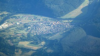
Heigenbrücken is a municipality in the Aschaffenburg district in the Regierungsbezirk of Lower Franconia (Unterfranken) in Bavaria, Germany, and seat of the Verwaltungsgemeinschaft of Heigenbrücken. It has a population of around 2,200.

Schönbrunn is a village in the heart of the Fichtelgebirge mountains in Bavaria, Germany. Since 1975 it is part of the town Wunsiedel. It has about 1,400 inhabitants, including the village Furthammer. It was founded around 1200 as a small settlement near a castle. The oldest surviving building is the church, built around 1200. Schönbrunn has a number of small businesses and less than 10 farms.

<span class="mw-page-title-main">Neuendorf, Bavaria</span> Municipality in Bavaria, Germany

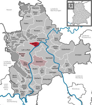
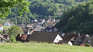
Neuendorf is a community in the Main-Spessart district in the Regierungsbezirk of Lower Franconia (Unterfranken) in Bavaria, Germany and a member of the Verwaltungsgemeinschaft of Lohr am Main.

<span class="mw-page-title-main">Lohr am Main</span> Place in Bavaria, Germany

Lohr am Main is a town in the Main-Spessart district in the Regierungsbezirk of Lower Franconia (Unterfranken) in Bavaria, Germany and the seat of the Verwaltungsgemeinschaft of Lohr am Main. It has a population of around 15,000.

<span class="mw-page-title-main">Rieneck</span> Town in Bavaria, Germany

Rieneck is a town in the Main-Spessart district in the Regierungsbezirk of Lower Franconia (Unterfranken) in Bavaria, Germany.

<span class="mw-page-title-main">Rothenfels</span> Town in Bavaria, Germany

Rothenfels is a town in the Main-Spessart district in the Regierungsbezirk of Lower Franconia (Unterfranken) in Bavaria, Germany and a member of the Verwaltungsgemeinschaft of Marktheidenfeld. With a population of just around 1,000 it is said to be Bavaria’s smallest town.

<span class="mw-page-title-main">Haibach, Lower Franconia</span> Municipality in Bavaria, Germany

Haibach is a community in the Aschaffenburg district in the Regierungsbezirk of Lower Franconia (Unterfranken) in Bavaria, Germany. It has a population of around 8,300.

<span class="mw-page-title-main">Mespelbrunn</span> Municipality in Bavaria, Germany

Mespelbrunn is a community in the Aschaffenburg district in the Regierungsbezirk of Lower Franconia (Unterfranken) in Bavaria, Germany and a member of the Verwaltungsgemeinschaft of Mespelbrunn, whose seat is in Heimbuchenthal.

<span class="mw-page-title-main">Weibersbrunn</span> Municipality in Bavaria, Germany

Weibersbrunn is a community with a population of close to 2,000 in the Aschaffenburg district in the Regierungsbezirk of Lower Franconia (Unterfranken) in Bavaria, Germany.

<span class="mw-page-title-main">Burgsinn</span> Municipality in Bavaria, Germany

Burgsinn is a market community in the Main-Spessart district in the Regierungsbezirk of Lower Franconia (Unterfranken) in Bavaria, Germany and the seat of the Verwaltungsgemeinschaft of Burgsinn. It has a population of around 2,500.

<span class="mw-page-title-main">Karsbach</span> Municipality in Bavaria, Germany

Karsbach is a municipality in the Main-Spessart district in the Regierungsbezirk of Lower Franconia (Unterfranken) in Bavaria, Germany and a member of the Verwaltungsgemeinschaft of Gemünden am Main.

<span class="mw-page-title-main">Neuhütten</span> Municipality in Bavaria, Germany

Neuhütten is a community in the Main-Spessart district in the Regierungsbezirk of Lower Franconia (Unterfranken) in Bavaria, Germany and a member of the Verwaltungsgemeinschaft of Partenstein. It has a population of around 1,100.

<span class="mw-page-title-main">Rechtenbach</span> Municipality in Bavaria, Germany

Rechtenbach is a community in the Main-Spessart district in the Regierungsbezirk of Lower Franconia (Unterfranken) in Bavaria, Germany and a member of the Verwaltungsgemeinschaft of Lohr am Main. It has a population of around 1,000.

<span class="mw-page-title-main">Dorfprozelten</span> Municipality in Bavaria, Germany

Dorfprozelten is a municipality in the Miltenberg district in the Regierungsbezirk of Lower Franconia (Unterfranken) in Bavaria, Germany. It is one of the oldest settlements on the Lower Main. Sandstone quarrying was a major industry once. The village has also long been known as the home of people involved in inland (river) navigation. Today, Dorfprozelten has a population of close to 1,800.

<span class="mw-page-title-main">Burgsponheim</span> Municipality in Rhineland-Palatinate, Germany

Burgsponheim is an Ortsgemeinde – a municipality belonging to a Verbandsgemeinde, a kind of collective municipality – in the Bad Kreuznach district in Rhineland-Palatinate, Germany. It belongs to the Verbandsgemeinde of Rüdesheim, whose seat is in the municipality of Rüdesheim an der Nahe. Burgsponheim is a winegrowing centre.

<span class="mw-page-title-main">Kirschroth</span> Municipality in Rhineland-Palatinate, Germany

Kirschroth is an Ortsgemeinde – a municipality belonging to a Verbandsgemeinde, a kind of collective municipality – in the Bad Kreuznach district in Rhineland-Palatinate, Germany. It belongs to the Verbandsgemeinde of Bad Sobernheim, whose seat is in the like-named town. Kirschroth is a state-recognized tourism community and a winegrowing village.

<span class="mw-page-title-main">Steinen, Rhineland-Palatinate</span> Municipality in Rhineland-Palatinate, Germany

Steinen is an Ortsgemeinde – a community belonging to a Verbandsgemeinde – in the Westerwaldkreis in Rhineland-Palatinate, Germany.

<span class="mw-page-title-main">Main–Spessart railway</span>

The Main-Spessart Railway is a 110 kilometre-long railway line in the Bavarian province of Lower Franconia and the neighbouring state of Hesse in south central Germany. It runs from Würzburg via Gemünden (Main) and Aschaffenburg to Hanau. It is particularly important for long-distance and goods traffic because it links the Rhine-Main conurbation immediately northwest of Aschaffenburg with the Lower Franconian city of Würzburg and beyond it to the metropoles of Nuremberg and Munich. Its name derives from the fact that it initially runs parallel to the River Main and then cuts through the Spessart hills. It was opened on 22 June 1854 by the Frankfurt-Hanau Railway Company and is one of the oldest railways in Germany.

<span class="mw-page-title-main">Hafenlohr (river)</span> River in Germany

Hafenlohr is a river of Bavaria, Germany. It is around 28 km (17 mi) long and discharges into the Main at the town of Hafenlohr. The Hafenlohr is located in the districts of Aschaffenburg and Main-Spessart in the Lower Franconia region.

References

  1. 1 2 Liste der ersten Bürgermeister/Oberbürgermeister in kreisangehörigen Gemeinden, Bayerisches Landesamt für Statistik, 15 July 2021.
  2. "Tabelle 12411-003r Fortschreibung des Bevölkerungsstandes: Gemeinden, Stichtag" (in German). Bayerisches Landesamt für Statistik. June 2022.