Freyung-Grafenau

Last updated
Freyung-Grafenau
Flagge Freyung-Grafenau.svg
DEU Landkreis Freyung-Grafenau COA.svg
Freyung-Grafenau
Country Germany
State Bavaria
Adm. region Lower Bavaria
Capital Freyung
Area
  Total984 km2 (380 sq mi)
Population
 (31 December 2022) [1]
  Total79,286
  Density81/km2 (210/sq mi)
Time zone UTC+01:00 (CET)
  Summer (DST) UTC+02:00 (CEST)
Vehicle registration FRG, WOS, GRA
Website freyung-grafenau.de

Freyung-Grafenau is a Landkreis (district) in Bavaria, Germany. It is bounded by (from the south and clockwise) the districts of Passau, Deggendorf and Regen, the Czech Republic and by Austria.

Contents

History

The district was established in 1972, by merging the former districts of Grafenau and Wolfstein. [2] In medieval times Wolfstein (east of the Ilz River) was the property of the bishop of Passau and the site of Wolfstein Castle, now a schloss . Grafenau (west of the Ilz River) successively belonged to different countries, before it was annexed by Bavaria in 1438. Wolfstein became a part of Bavaria two years after the dissolution of the clerical states in Germany (1803).

Geography

Freyung Freyung.jpg
Freyung

Freyung-Grafenau is the easternmost district of Bavaria. It is located in the southern part of the Bavarian Forest and is partially occupied by the Bavarian Forest National Park. The source of the Ilz River is situated in the district.

Coat of arms

The wolf represents the area of Wolfstein, while the bear stands for Grafenau (as it was ruled from the castle of Bärnstein, and Bär means "bear"). At the bottom sits the blue and white lozengy pattern of Bavaria.

Towns and municipalities

Clickable map of towns and municipalities in the district Municipalities in FRG.svgWaldhäuserwaldSchönbrunner WaldSchlichtenberger WaldSankt Oswald (unincorporated area)Pleckensteiner WaldPhilippsreuter WaldMauther ForstGraineter WaldAnnathaler WaldSchönbergGrafenauFreyungLeopoldsreuter WaldFrauenberger und Duschlberger Wald
Clickable map of towns and municipalities in the district
TownsMunicipalities
  1. Freyung
  2. Grafenau
  3. Waldkirchen
  1. Eppenschlag
  2. Fürsteneck
  3. Grainet
  4. Haidmühle
  5. Hinterschmiding
  6. Hohenau
  7. Innernzell
  8. Jandelsbrunn
  9. Mauth
  10. Neureichenau
  11. Neuschönau
  1. Perlesreut
  2. Philippsreut
  3. Ringelai
  4. Röhrnbach
  5. Saldenburg
  6. Sankt Oswald-Riedlhütte
  7. Schöfweg
  8. Schönberg
  9. Spiegelau
  10. Thurmansbang
  11. Zenting

See also

Schneekirche

Related Research Articles

Passau is a Landkreis (district) in the southeast of Bavaria, Germany. It encloses the city of Passau geographically from two sides. Neighboring districts are Rottal-Inn, Deggendorf, Freyung-Grafenau. To the south it borders Austria.

Deggendorf is a Landkreis (district) in Bavaria, Germany. It is bordered by the districts of Regen, Freyung-Grafenau, Passau, Rottal-Inn, Dingolfing-Landau and Straubing-Bogen.

Regen is a Landkreis (district) in Bavaria, Germany. It is bounded by the districts of Freyung-Grafenau, Deggendorf, Straubing-Bogen and Cham, and by the Czech Republic.

<span class="mw-page-title-main">Veste Oberhaus</span> Fortress in Germany

Veste Oberhaus is a fortress that was founded in 1219 and, for most of its time, served as the stronghold of the Bishop of Passau, Germany. It is currently the site of a museum, a youth hostel, and a restaurant, as well as an open-air theatre dating to 1934.

<span class="mw-page-title-main">Waldkirchen</span> Town in Bavaria, Germany

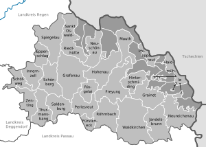
Waldkirchen is the biggest town in the district of Freyung-Grafenau in Germany.

<span class="mw-page-title-main">Freyung, Bavaria</span> Town in Bavaria, Germany

Freyung is a town in Bavaria, Germany, capital of the Freyung-Grafenau district. It is situated in the Bavarian Forest mountain range, near the border with Austria and the Czech Republic.

<span class="mw-page-title-main">Grafenau, Bavaria</span> Town in Bavaria, Germany

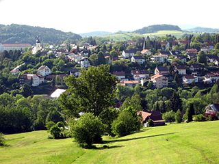
Grafenau is a town in the Freyung-Grafenau district, in Bavaria, Germany. 32 km north of Passau, the town is situated in the Bavarian Forest and is the base of the Bavarian Forest National Park Authority. Grafenau is a holiday destination with a variety of kinds of accommodation from self-catering apartments to a "holiday village".

<span class="mw-page-title-main">Haidmühle</span> Municipality in Bavaria, Germany

Haidmühle (Czech: Borské Mlýny is a municipality in the district of Freyung-Grafenau in Bavaria in Germany.

<span class="mw-page-title-main">Philippsreut</span> Municipality in Bavaria, Germany

Philippsreut is a municipality in the district of Freyung-Grafenau in Bavaria, Germany. It lies on the border with the Czech Republic.

<span class="mw-page-title-main">Spiegelau</span> Municipality in Bavaria, Germany

Spiegelau is a municipality in the district of Freyung-Grafenau in Bavaria in Germany. It lies in the heart of the Bavarian Forest.

<span class="mw-page-title-main">Zenting</span> Municipality in Bavaria, Germany

Zenting is a municipality in the district of Freyung-Grafenau in Bavaria in Germany.

The town of Fuersteneck, near Grafenau in Bavaria, Germany, was the location of a witch trial in 1703. A record of the trial was obtained from the parsonage of Röhrnbach.

<span class="mw-page-title-main">Passau–Freyung railway</span>

The Passau–Freyung railway, also known as the Ilz Valley Railway or Ilztalbahn, is a branch line in Bavaria, Germany. It runs from Passau to the town of Freyung in the Bavarian Forest. At Kalteneck it forms a junction with the branch line to Eging-Deggendorf. At Waldkirchen the Waldkirchen–Haidmühle line branches off towards the Czech border, where since 1945 there has been a junction with the Czech railway network.

Wollaberg is a small town in the district of Freyung-Grafenau in Bavaria in Germany.

<span class="mw-page-title-main">Oberfrauenwald</span> Mountain in Germany

Oberfrauenwald is a 947.7 m (3,109 ft) high wooded mountain in the southern Bavarian Forest in Bavaria, Germany. It is positioned between the cities of Waldkirchen and Hauzenberg. The district borders between Passau and Freyung-Grafenau run over the mountain's peaks.

<span class="mw-page-title-main">Deggendorf (electoral district)</span> Federal electoral district of Germany

Deggendorf is an electoral constituency represented in the Bundestag. It elects one member via first-past-the-post voting. Under the current constituency numbering system, it is designated as constituency 227. It is located in southeastern Bavaria, comprising the districts of Deggendorf and Freyung-Grafenau.

<span class="mw-page-title-main">Pfahl (Bavarian Forest)</span>

The Pfahl is a 150-kilometre-long quartz vein that runs through the northeastern Bavarian Forest in Germany. From a geomorphological point of view, it represents a residual ridge that has been formed by weathering and erosion over millions of years.

<span class="mw-page-title-main">Buchberger Leite</span>

The Buchberger Leite is a gorge near Hohenau in the Lower Bavarian county of Freyung-Grafenau in Bavaria.

<span class="mw-page-title-main">Wolfstein Castle</span>

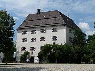
Wolfstein Castle or Schloss Wolfstein is a schloss and former castle in Freyung in Lower Bavaria. It gave its name to the county of Wolfstein which was dissolved in 1972.

References

  1. Genesis Online-Datenbank des Bayerischen Landesamtes für Statistik Tabelle 12411-003r Fortschreibung des Bevölkerungsstandes: Gemeinden, Stichtag (Einwohnerzahlen auf Grundlage des Zensus 2011)
  2. F.A. Brockhaus Wiesbaden (1975). Brockhaus Enzyklopädie in zwanzig Bänden: Ergänzungen, A-I (in German) (17 ed.). Wiesbaden. p. 517. ISBN   978-3765300288.

48°50′N13°30′E / 48.83°N 13.5°E / 48.83; 13.5