Philippsreut

Last updated
Philippsreut
Philippsreut.jpg
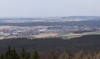
Philippsreut as seen from the Haidel
DEU Philippsreut COA.svg
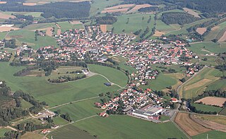
Location of Philippsreut within Freyung-Grafenau district
Philippsreut in FRG.svgWaldhäuserwaldSchönbrunner WaldSchlichtenberger WaldSankt Oswald (unincorporated area)Pleckensteiner WaldPhilippsreuter WaldMauther ForstGraineter WaldAnnathaler WaldSchönbergGrafenauFreyungLeopoldsreuter WaldFrauenberger und Duschlberger Wald
Germany adm location map.svg
Red pog.svg
Philippsreut
Bavaria location map.svg
Red pog.svg
Philippsreut
Coordinates: 48°52′N13°41′E / 48.867°N 13.683°E / 48.867; 13.683
Country Germany
State Bavaria
Admin. region Niederbayern
District Freyung-Grafenau
Municipal assoc. Hinterschmiding
Government
   Mayor (202026) Helmut Knaus [1] (FW)
Area
  Total10.16 km2 (3.92 sq mi)
Highest elevation
1,139 m (3,737 ft)
Lowest elevation
840 m (2,760 ft)
Population
 (2021-12-31) [2]
  Total642
  Density63/km2 (160/sq mi)
Time zone UTC+01:00 (CET)
  Summer (DST) UTC+02:00 (CEST)
Postal codes
94158
Dialling codes Philippsreut 08550/ Mitterfirmiansreut 08557/
Vehicle registration FRG
Website www.philippsreut.de

Philippsreut is a municipality in the district of Freyung-Grafenau in Bavaria, Germany. It lies on the border with the Czech Republic.

The village was founded in 1692 by Johann Philipp von Lamberg, Bishop of Passau, originally under the name Kleinphilippsreut ("Small Philip's Glade"), which name lasted until 1936. In times of founding it used to be a drinking station on the middle branch of the so-called "Golden Trail" (German : Goldener Steig), an important medieval trade route connecting Bavaria and Bohemia. When trade on the Golden Trail gradually disappeared (during the first half of the 18th century), the village remained a poor mountainous settlement, whose inhabitants lived – like the other peoples in the Bavarian/Bohemian Forest – mainly from logging and glassmaking. Today, main source of livelihood is tourism.

Despite its negligible size and remote location, Philippsreut has very good transport connections: here ends the Bundesstraße (federal highway) B12 and is continued on the Czech side by the silnice I/4 (road of 1st class) which heads towards Prague.

Related Research Articles

<span class="mw-page-title-main">Bayerisch Eisenstein</span> Municipality in Bavaria, Germany

Bayerisch Eisenstein, until 1951 just Eisenstein is a village and a municipality in the Regen district, in Bavaria, Germany.

<span class="mw-page-title-main">Schwandorf</span> Town in Bavaria, Germany

Schwandorf is a town on the river Naab in the Upper Palatinate, Bavaria, Germany, which is the seat of the Schwandorf district.

<span class="mw-page-title-main">Tirschenreuth</span> Town in Bavaria, Germany

Tirschenreuth is the capital city of the district of Tirschenreuth. It is located in the northeast of Bavaria, very close to the Czech-Bavarian border.

<span class="mw-page-title-main">Waldkirchen</span> Town in Bavaria, Germany

Waldkirchen is the biggest town in the district of Freyung-Grafenau in Germany.

<span class="mw-page-title-main">Rimbach, Upper Palatinate</span> Municipality in Bavaria, Germany

Rimbach is a municipality in the district of Cham (district) in the Upper Palatinate in Bavaria in Germany.

<span class="mw-page-title-main">Georgenberg, Neustadt</span> Municipality in Bavaria, Germany

Georgenberg is a municipality in the district of Neustadt an der Waldnaab in Bavaria in Germany, on the border with the Czech Republic.

<span class="mw-page-title-main">Schäftlarn</span> Municipality in Bavaria, Germany

Schäftlarn is a municipality in the district of Munich in Bavaria in Germany. It consists of the villages Ebenhausen, Hohenschäftlarn, Kloster Schäftlarn, Neufahrn and Zell. The river Isar runs through it. A human settlement with the name "Schäftlarn" does not exist.

<span class="mw-page-title-main">Schönsee</span> Town in Bavaria, Germany

Schönsee is a town in the Schwandorf district of Bavaria, Germany, near the border with the Czech Republic, 38 km northeast of Schwandorf, and 34 km southeast of Weiden in der Oberpfalz.

<span class="mw-page-title-main">Rehau</span> Town in Bavaria, Germany

Rehau is a town in the district of Hof, in Bavaria, Germany. The first documented name of Rehau was "Resawe" in the year 1234. Rehau is situated in the Fichtelgebirge, 12 km southeast of Hof, and 12 km west of Aš. Formerly a fairly isolated town, located as it is near both Czech and former East German borders, with the fall of The Wall, it is now in the centre of a growing area, with a new Autobahn providing ready access from Nuremberg and Munich.

<span class="mw-page-title-main">Veitshöchheim</span> Municipality in Bavaria, Germany

Veitshöchheim is a municipality in the district of Würzburg, in Bavaria, Germany. It is situated on the right bank of the Main, 6 kilometres (4 mi) northwest of Würzburg. Veitshöchheim has a population just under 10,000. It includes two villages: Veitshöchheim and Gadheim

<span class="mw-page-title-main">Freyung, Bavaria</span> Town in Bavaria, Germany

Freyung is a town in Bavaria, Germany, capital of the Freyung-Grafenau district. It is situated in the Bavarian Forest mountain range, near the border with Austria and the Czech Republic.

<span class="mw-page-title-main">Pfreimd</span> Town in Bavaria, Germany

Pfreimd is a town in the district of Schwandorf, in Bavaria, Germany. It is situated on the river Naab, 19 km north of Schwandorf, and 20 km south of Weiden in der Oberpfalz. It is also close to the border with the Czech Republic.

<span class="mw-page-title-main">Waidhaus</span> Municipality in Bavaria, Germany

Waidhaus is a municipality in the district of Neustadt an der Waldnaab in Bavaria, Germany. It lies near the border with the Czech Republic, and near the major border crossing between Bavaria and the Czech Republic, where the Bavarian A6 meets the Czech D5 motorway. The closest towns are on the German side Pleystein and on the Czech side Rozvadov. A gas pipeline and a powerline also cross the border between Bavaria and the Czech Republic there.

<span class="mw-page-title-main">Gundelsheim, Bavaria</span> Municipality in Bavaria, Germany

Gundelsheim is a community in the Upper Franconian district of Bamberg.

<span class="mw-page-title-main">Heroldsberg</span> Municipality in Bavaria, Germany

Heroldsberg is a municipality in the district of Erlangen-Höchstadt, in Bavaria, Germany. It is located eleven kilometers north-east from the city of Nuremberg and 23 kilometers east from Erlangen and is the headquarters of Schwan-Stabilo.

<span class="mw-page-title-main">Haidmühle</span> Municipality in Bavaria, Germany

Haidmühle (Czech: Borské Mlýny is a municipality in the district of Freyung-Grafenau in Bavaria in Germany.

<span class="mw-page-title-main">Valley, Bavaria</span> Municipality in Bavaria, Germany

Valley is a municipality in the district of Miesbach in Bavaria in Germany. The municipality of Valley holds, as of 2006, 2949 inhabitants.

<span class="mw-page-title-main">Floß</span> Municipality in Bavaria, Germany

Floß is a municipality in the district of Neustadt an der Waldnaab in Bavaria, Germany.

<span class="mw-page-title-main">Sonnen</span> Municipality in Bavaria, Germany

Sonnen is a small municipality in the district of Passau in Bavaria in Germany. It is located in the Danube forest, lower Bavarian forest and is located mostly in the district Passau at a height of 700 to 900 meters. Sonnen lies 28 km from Passau, 9 km from Hauzenberg and from the forest itself 13 km. Sonnen borders with upper Austria which lies only 8 km away.

<span class="mw-page-title-main">Frankenwinheim</span> Municipality in Bavaria, Germany

Frankenwinheim is a village in the district of Schweinfurt in Bavaria, Germany and part of Verwaltungsgemeinschaft Gerolzhofen.

References

  1. Liste der ersten Bürgermeister/Oberbürgermeister in kreisangehörigen Gemeinden, Bayerisches Landesamt für Statistik, 15 July 2021.
  2. "Tabelle 12411-003r Fortschreibung des Bevölkerungsstandes: Gemeinden, Stichtag" (in German). Bayerisches Landesamt für Statistik. June 2022.