Traunstein

Last updated

Traunstein
Traunstein 032.JPG
Market square
Wappen Traunstein.svg
Location of Traunstein within Traunstein district
Traunstein in TS.svgPettingNußdorfKienbergGrassauBergen
Germany adm location map.svg
Red pog.svg
Traunstein
Bavaria location map.svg
Red pog.svg
Traunstein
Coordinates: 47°52′N12°38′E / 47.867°N 12.633°E / 47.867; 12.633
Country Germany
State Bavaria
Admin. region Oberbayern
District Traunstein
Government
   Lord mayor (202026) Christian Hümmer [1] (CSU)
Area
  Total48.53 km2 (18.74 sq mi)
Elevation
591 m (1,939 ft)
Population
 (2022-12-31) [2]
  Total21,251
  Density440/km2 (1,100/sq mi)
Time zone UTC+01:00 (CET)
  Summer (DST) UTC+02:00 (CEST)
Postal codes
83278
Dialling codes 0861
Vehicle registration TS
Website www.traunstein.de
St. Oswald's Church, Market Square, Traunstein (It was home to a pectoral cross worn by Pope Emeritus Benedict XVI until it was stolen in June of 2023) St. Oswald Kirche Traunstein.JPG
St. Oswald's Church, Market Square, Traunstein (It was home to a pectoral cross worn by Pope Emeritus Benedict XVI until it was stolen in June of 2023)
View south towards the Alps from the Hochberg, Traunstein Traunstein - Hochberg Ri S, Tal weisse Traun.JPG
View south towards the Alps from the Hochberg, Traunstein

Traunstein (Central Bavarian: Traunstoa) is a town in the south-eastern part of Bavaria, Germany, and is the administrative center of a much larger district of the same name. The town serves as a local government, retail, health services, transport and educational center for the wider district.

Contents

The historic market square, Bavarian hospitality, local breweries, outdoor sports facilities, Easter Monday horse parade, and connections with Pope Emeritus Benedict XVI, contribute to the town's profile as a tourist destination.

Geography

The town is situated at the heart of a region called Chiemgau, approximately 11 km east of the Chiemsee between Munich and Salzburg, 15 km north of the Alps, and 30 km west of Salzburg.

History

Early history

Although as early as 790 the church records list possessions "ad Trun" and some medieval defence constructions are known to have existed in the surroundings since the 10th century, Trauwenstein itself was first mentioned in a manuscript of the Baumburg monastery in the year 1245. The name means "castle on the Traun", and the domicile of the Lord of "de Truna", surrounded by a little settlement, was probably located there.[ citation needed ]

The Wittelsbachs (a German/Bavarian dynastic and European royal family) were the first to expand and fortify the settlement. In that way they controlled the passage of the important commercial salt route over the Traun, from Bad Reichenhall to Munich at the border of the "Erzstift Salzburg" (the archbishopric of Salzburg). In the year 1120 the lords of "Truna" settled in the current urban area because of its favourable strategic position. They built the castle at the border of the city plateau, which is surrounded by the River Traun as well as its close proximity to the main route of commerce.[ citation needed ]

Traunstein has been part of the state of Bavaria since 1275. It was previously a territory of Salzburg. At the beginning of the 14th century, Traunstein was granted the status of a town. By 1493 the town roads were already cobbled. The Church of St. Oswald was rebuilt in 1501. In 1526 the Lindlbrunnen (Lindl Fountain) was constructed as a completion of the town's water supply.[ citation needed ]

In the 17th century, salt production, facilitated by the construction of a wooden brine pipeline from Bad Reichenhall brought new industry and significant wealth to the town. The pipeline was constructed between 1616 and 1619 by the master builder of the court, Hans Reiffenstuel.[ citation needed ]

Traunstein was spared much of the damage experienced by nearby towns during the Thirty Years' War (1618–1648). [ clarification needed ][ citation needed ]

On 25 and 26 July 1704, Austrian troops occupied the town in the course of the Spanish war of succession. A disastrous fire altered the medieval townscape. Despite the occupation by Austrian troops, it was possible for Traunstein to be reconstructed. The saltworks, finished in 1786/87, assured the survival of salt production in Traunstein.[ citation needed ]

Town fires

In its history, Traunstein was struck at least twice by significant town fires: In 1704, when Hungarian "Panduren" set the town on fire in the course of the Spanish War of Succession, and in 1851. However, the "first town fire", which is still familiar to all "real" citizens of Traunstein and is still taught in school today, has not been confirmed. Only archaeological excavations can show whether Traunstein had really suffered a fire disaster before 1400. Written documents provide no information about it. They merely report about a fire, which broke out later, in 1851. At any rate, only 10 houses fell victim to the early fire and in no case the whole town. Thereupon, in 1587, a fire arrangement was enacted for the first time in the town history.

During the night of 25-26 April 1851, a disastrous fire again destroyed almost the whole town. The reason for it has never been discovered. The great fires spread to almost 100 houses including the Town Hall, the County Court, the Main Salt Office, the Pension Office, the Church, and several gates and towers except the Upper Tower. Just as in 1704, Traunstein was again rebuilt within a few years. It was presumed the fire was an act of revenge by the angry Haslachers. There were feelings of rage because the parochial seat was taken away from Haslach and was given to Traunstein. Later rumours came up that the carelessness of a resident had caused the fire. However, there was no evidence to support that idea and therefore the person could not be sentenced.

After the town fire 700 citizens were homeless but help immediately reached Traunstein. King Maximilian II visited Traunstein on 27 April, contributed consolations and gave several thousands of guilders from his cabinet cash. In return for the quick payment of the fire insurance the inhabitants could soon begin to rebuild their town from the ground up. The medieval plan of the town square was preserved to a great extent; merely the façades received a new face in the style of the current time.

1900 to present

Salt production in Traunstein was finally shut down in 1912. In 1914, the former independent community "Au" became part of Traunstein.

During the First World War what had previously been the site of the salt production facilities became a camp for over 1000 civilian prisoners and prisoners of war. After the war, the 1923 hyperinflation crisis as in other towns lead to the use of token money denominated in billions.

Traunstein in 1930. View of the town from the North. The Hochfelln and Hochgern mountains in the background. 19300101 Grainer Traunstein Weinleite.jpg
Traunstein in 1930. View of the town from the North. The Hochfelln and Hochgern mountains in the background.

With the seizure of power of the National Socialists in 1933 began an active period of persecution for political dissidents and Jewish fellow citizens in Germany. By November 1938 all Jewish residents of the town had been forcibly removed. Open political resistance during the war years was limited; the town priest, Josef Stelze, was placed briefly in custody, Rupert Berger, Bavarian People's Party representative and the first post-war elected Mayor of Traunstein, was for a period incarcerated in the Dachau concentration camp. In 1939 Traunstein had an estimated population of 11,500. By the end of the war 523 of that number were registered as killed as a direct result of the conflict, a further 73 registered as missing. [4]

During the later stages of the Second World War Traunstein was four times the target of U.S. Army Air Force aerial bombardment: on 11 November 1944, on 21 January 1945, on 18 April 1945 and finally on 25 April 1945. In April 1945 the heavy air raids destroyed much of the Traunstein station area, an event in which over 100 people died. A short time later, a death march with a few SS guards accompanied by 61 prisoners from the already-liberated Buchenwald concentration camp arrived; and on 5 May a massacre was carried out, resulting in 60 deaths, and only one survivor. Currently in Surberg lies a memorial commemorating their deaths. On 3 May 1945 the town surrendered without struggle.

During World War II, a subcamp of Dachau concentration camp was located here. [5] Whereas Traunstein was a district-free city from 1948–1972, it became capital of the district of the same name in 1972.

Areas of Traunstein close to the River Traun have been subject to flooding on numerous occasions, most notably in 1899 [6] and again in 2013. [7]

Climate

Climate data for Traunstein (Chieming, 1991–2020 normal)
MonthJanFebMarAprMayJunJulAugSepOctNovDecYear
Mean daily maximum °C (°F)3.3
(37.9)
5.1
(41.2)
9.6
(49.3)
15.0
(59.0)
18.5
(65.3)
22.5
(72.5)
24.1
(75.4)
23.5
(74.3)
18.9
(66.0)
14.5
(58.1)
8.3
(46.9)
4.7
(40.5)
14.0
(57.2)
Daily mean °C (°F)−0.2
(31.6)
0.6
(33.1)
4.5
(40.1)
9.4
(48.9)
13.1
(55.6)
17.2
(63.0)
18.6
(65.5)
18.0
(64.4)
13.7
(56.7)
9.7
(49.5)
4.5
(40.1)
1.0
(33.8)
9.5
(49.1)
Mean daily minimum °C (°F)−3.4
(25.9)
−2.7
(27.1)
0.4
(32.7)
3.8
(38.8)
7.9
(46.2)
12.0
(53.6)
13.2
(55.8)
12.8
(55.0)
9.2
(48.6)
5.4
(41.7)
1.0
(33.8)
−2.1
(28.2)
4.9
(40.8)
Mean monthly sunshine hours 70.995.9143.7202.3195.9224.7241.1230.1172.9130.980.172.41,843.1
Source: NOAA [8]

Transport

Notable people

St. Michael Seminary, Traunstein Studienseminar St. Michael Aussen.jpg
St. Michael Seminary, Traunstein

Twin towns – sister cities

Traunstein is twinned with: [11]

Traunstein is the setting for the Austrian-German television crime drama series Der Pass .

Related Research Articles

<span class="mw-page-title-main">Berchtesgaden</span> Municipality in Bavaria, Germany

Berchtesgaden is a municipality in the district Berchtesgadener Land, Bavaria, in southeastern Germany, near the border with Austria, 30 km (19 mi) south of Salzburg and 180 km (110 mi) southeast of Munich. It lies in the Berchtesgaden Alps. South of the town, the Berchtesgaden National Park stretches along three parallel valleys.

<span class="mw-page-title-main">Upper Bavaria</span> Regierungsbezirk in Bavaria, Germany

Upper Bavaria is one of the seven administrative districts of Bavaria, Germany.

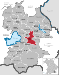
Berchtesgadener Land is a Landkreis (district) in Bavaria, Germany. It is bounded by the district of Traunstein and by the state of Austria.

<span class="mw-page-title-main">Landshut</span> Town in Bavaria, Germany

Landshut is a town in Bavaria in the south-east of Germany. Situated on the banks of the River Isar, Landshut is the capital of Lower Bavaria, one of the seven administrative regions of the Free State of Bavaria. It is also the seat of the surrounding district and has a population of more than 75,000. Landshut is the largest city in Lower Bavaria, followed by Passau and Straubing, and Eastern Bavaria's second after Regensburg.

<span class="mw-page-title-main">Dachau concentration camp</span> Nazi concentration camp in Germany before and during World War II

Dachau was one of the first concentration camps built by Nazi Germany and the longest running one, opening on 22 March 1933. The camp was initially intended to intern Hitler's political opponents, which consisted of communists, social democrats, and other dissidents. It is located on the grounds of an abandoned munitions factory northeast of the medieval town of Dachau, about 16 km (10 mi) northwest of Munich in the state of Bavaria, in southern Germany. After its opening by Heinrich Himmler, its purpose was enlarged to include forced labor, and eventually, the imprisonment of Jews, Romani, German and Austrian criminals, and, finally, foreign nationals from countries that Germany occupied or invaded. The Dachau camp system grew to include nearly 100 sub-camps, which were mostly work camps or Arbeitskommandos, and were located throughout southern Germany and Austria. The main camp was liberated by U.S. forces on 29 April 1945.

<span class="mw-page-title-main">Salzkammergut</span> Resort area in Austria

The Salzkammergut is a resort area in Austria, stretching from the city of Salzburg eastwards along the Alpine Foreland and the Northern Limestone Alps to the peaks of the Dachstein Mountains. The main river of the region is the Traun, a right tributary of the Danube.

<span class="mw-page-title-main">Reit im Winkl</span> Municipality in Bavaria, Germany

Reit im Winkl is a small village located on the German/Austrian border in the southeastern part of Bavaria, Germany. Part of the Traunstein district, it was previously an immigration and customs control point. It is situated south of Chiemsee and southwest of Ruhpolding – home of the Biathlon World Cup – in the Bavarian Alps and facing towards Tyrol. The village lies next to the Austrian states Tyrol and Salzburg. Kössen in Tyrol is the next village on the river Lofer, before it joins the confluence of the river Tiroler Achen. Reit im Winkl has a population of approximately 2,600.

<span class="mw-page-title-main">Hallein</span> Municipality in Salzburg, Austria

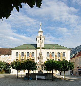
Hallein is a historic town in the Austrian state of Salzburg. It is the capital of Hallein district.

The early life of Pope Benedict XVI concerns the period from his birth in 1927 through the completion of his education and ordination in 1951.

<span class="mw-page-title-main">Bad Reichenhall</span> Town in Bavaria, Germany

Bad Reichenhall is a spa town, and administrative center of the Berchtesgadener Land district in Upper Bavaria, Germany. It is located near Salzburg in a basin encircled by the Chiemgau Alps. Together with other alpine towns Bad Reichenhall engages in the Alpine Town of the Year Association for the implementation of the Alpine Convention to achieve sustainable development in the alpine arc. Bad Reichenhall was awarded Alpine Town of the Year in 2001.

<span class="mw-page-title-main">Tittmoning</span> Town in Bavaria, Germany

Tittmoning is a town in the district of Traunstein, in Bavaria, Germany.

<span class="mw-page-title-main">History of Munich</span> Occurrences and people in Munich throughout history

Events in the history of Munich in Germany.

<span class="mw-page-title-main">Waging am See</span> Municipality in Bavaria, Germany

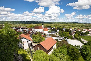
Waging am See is a municipality in the district of Traunstein in Bavaria, Germany. The town, classified as a climatic spa, is located at the Waginger See, the warmest lake in Upper Bavaria, with temperatures up to 27 °C.

<span class="mw-page-title-main">Bavarian uprising of 1705–1706</span>

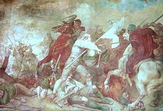
The Bavarian uprising of 1705–1706 was a revolt against the occupation of the Electorate of Bavaria by the Imperial Army of the Habsburg Monarchy during the War of the Spanish Succession (1701–1714). It lasted from early November 1705 to 18 January 1706, approximately 75 days. Henric L. Wuermeling speaks of this as "the first revolution of modern history."

<i>Postenpflicht</i> Nazi policy against insubordinate prisoners

The Postenpflicht was a general order issued to SS-Totenkopfverbände guards in Nazi concentration camps to summarily execute insubordinate prisoners. The order required guards to shoot prisoners who engaged in resistance or escape attempts, without warning; failing to do so would result in dismissal or arrest. The Postenpflicht was originally issued on October 1, 1933, for guards at Dachau concentration camp, but was later extended to other concentration camps.

Hofbräuhaus Traunstein is a beer brewery in Traunstein, southeastern Bavaria, Germany.

<span class="mw-page-title-main">Rupertiwinkel</span>

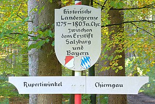
The Rupertiwinkel is a small historic region on the southeastern border of Bavaria, Germany. Part of the Archbishopric of Salzburg until the early 19th century, it is named after the first Salzburg bishop Saint Rupert (c.660–710), apostle to the Duchy of Bavaria.

The Rosenheim–Salzburg railway is a continuous double track and electrified main line railway almost entirely within the German state of Bavaria. It is an international transport corridor, linking Rosenheim to Salzburg in Austria.

<span class="mw-page-title-main">Traunstein station</span> Railway station in Traunstein, Germany

Traunstein station is the only station of the large district town of Traunstein in the German state of Bavaria. It has four main line platform tracks and two bay platform tracks and is classified by Deutsche Bahn as a category 4 station. The station is a rail junction and is located on the Rosenheim–Salzburg, Traunstein–Ruhpolding, Traunstein–Waging and Traunstein–Garching lines.

<span class="mw-page-title-main">Bundesstraße 304</span> German federal highway

The Bundesstraße 304 is a German federal highway that runs from Dachau north of Munich through the Bavarian capital via Ebersberg, Wasserburg am Inn and Traunstein to Freilassing on the border with Austria (Salzburg).

References

  1. Liste der ersten Bürgermeister/Oberbürgermeister in kreisangehörigen Gemeinden, Bayerisches Landesamt für Statistik, 15 July 2021.
  2. Genesis Online-Datenbank des Bayerischen Landesamtes für Statistik Tabelle 12411-003r Fortschreibung des Bevölkerungsstandes: Gemeinden, Stichtag (Einwohnerzahlen auf Grundlage des Zensus 2011)
  3. CNA. "Pectoral cross of Benedict XVI stolen from Bavarian church". Catholic News Agency. Retrieved 30 December 2023.
  4. "Traunstein Town History". Town History Timeline. Traunstein Local Government. Archived from the original on 28 May 2014. Retrieved 28 May 2014.
  5. "Linde, Land Nordrhein-Westfalen, Germany - Pages - glosk". Archived from the original on 9 February 2009. Retrieved 1 November 2008.
  6. "Traunstein Town History". Town History Timeline. Traunstein Local Government. Archived from the original on 28 May 2014. Retrieved 28 May 2014.
  7. "Presseberichte - Stadt Traunstein". www.traunstein.de. Archived from the original on 23 June 2013.
  8. "Chieming Climate Normals 1991–2020". National Oceanic and Atmospheric Administration. Archived from the original on 16 September 2023. Retrieved 16 September 2023.
  9. Shirer, William L. (1960). The Rise and Fall of the Third Reich : a History of Nazi Germany. New York: Fawcett Crest. p. 59. ISBN   0-449-21977-1. OCLC   27320017.
  10. Dawidowicz, Lucy S. (2010). The war against the Jews, 1933-1945. Open Road Integrated Media. ISBN   978-1-4532-0306-4. OCLC   768349464.
  11. "Städtepartnerschaften". traunstein.de (in German). Traunstein. Retrieved 28 February 2021.