Petting, Bavaria

Last updated
Petting
Petting.jpg
Petting as viewed from South
DEU Petting COA.svg
Coat of arms
Germany adm location map.svg
Red pog.svg
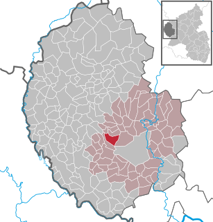
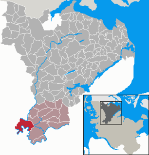
Petting
Location of Petting within Traunstein district
Petting in TS.svg
Coordinates: 47°55′N12°49′E / 47.917°N 12.817°E / 47.917; 12.817 Coordinates: 47°55′N12°49′E / 47.917°N 12.817°E / 47.917; 12.817
Country Germany
State Bavaria
Admin. region Oberbayern
District Traunstein
Government
   Mayor Karl Lanzinger (CSU)
Area
  Total 29.93 km2 (11.56 sq mi)
Elevation 451 m (1,480 ft)
Population (2017-12-31) [1]
  Total 2,327
  Density 78/km2 (200/sq mi)
Time zone CET/CEST (UTC+1/+2)
Postal codes 83367, 83419
Dialling codes 08686
Vehicle registration TS
Website www.gemeinde-petting.de

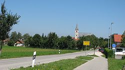
Petting is a municipality in the district Traunstein, Bavaria, Germany. It is located on the shore of the Waginger See, a diluvial lake.

Municipalities of Germany the lowest official level of territorial division in Germany

Municipalities are the lowest level of official territorial division in Germany. This is most commonly the third level of territorial division, ranking after the Land (state) and Kreis (district). The Gemeinde which is one level lower in those states also includes Regierungsbezirke as an intermediate territorial division. The Gemeinde is one level higher if it is not part of a Samtgemeinde. Only 10 municipalities in Germany have fifth level administrative subdivisions and all of them are in Bavaria. The highest degree of autonomy may be found in the Gemeinden which are not part of a Kreis. These Gemeinden are referred to as Kreisfreie Städte or Stadtkreise, sometimes translated as having "city status". This can be the case even for small municipalities. However, many smaller municipalities have lost this city status in various administrative reforms in the last 40 years when they were incorporated into a Kreis. In some states they retained a higher measure of autonomy than the other municipalities of the Kreis. Municipalities titled Stadt are urban municipalities while those titled Gemeinde are classified as rural municipalities.

Traunstein (district) District in Bavaria, Germany

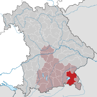
Traunstein is a Landkreis (district) in the southeastern part of Bavaria, Germany. Neighboring districts are Mühldorf, Altötting, the Austrian states Upper Austria and Salzburg, the district Berchtesgadener Land, the Austrian states of Salzburg and Tyrol, and the district Rosenheim.

Bavaria State in Germany

Bavaria, officially the Free State of Bavaria, is a landlocked federal state of Germany, occupying its southeastern corner. With an area of 70,550.19 square kilometres, Bavaria is the largest German state by land area comprising roughly a fifth of the total land area of Germany. With 13 million inhabitants, it is Germany's second-most-populous state after North Rhine-Westphalia. Bavaria's main cities are Munich and Nuremberg.

The first mention of the municipality was in 1048 with the name Pettinga; however, it is possible that the settlement already existed at the time of the Roman Empire. In 1180 it came into the ownership of the monastery St. Zeno.

Roman Empire Period of Imperial Rome following the Roman Republic (27 BC–476 AD)

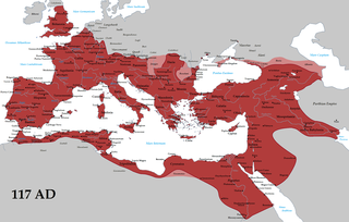
The Roman Empire was the post-Roman Republic period of the ancient Roman civilization. Ruled by emperors, it had large territorial holdings around the Mediterranean Sea in Europe, North Africa, the Middle East, and the Caucasus. From the constitutional reforms of Augustus to the military anarchy of the third century, the Empire was a principate ruled from the city of Rome. The Roman Empire was then ruled by multiple emperors and divided in a Western Roman Empire, based in Milan and later Ravenna, and an Eastern Roman Empire, based in Nicomedia and later Constantinople. Rome remained the nominal capital of both parts until 476 AD, when Odoacer deposed Romulus Augustus after capturing Ravenna and the Senate of Rome sent the imperial regalia to Constantinople. The fall of the Western Roman Empire to barbarian kings, along with the hellenization of the Eastern Roman Empire into the Byzantine Empire, is conventionally used to mark the end of Ancient Rome and the beginning of the Middle Ages.

Related Research Articles

Daaden Place in Rhineland-Palatinate, Germany

Daaden is a municipality in the district of Altenkirchen, in Rhineland-Palatinate, Germany. It is situated in the Westerwald, approx. 15 km south-west of Siegen.

Arzfeld Place in Rhineland-Palatinate, Germany

Arzfeld is a municipality in the district Bitburg-Prüm, in Rhineland-Palatinate, Germany. It is situated in the Eifel, near the border with Luxembourg, approx. 20 km north-west of Bitburg and 25 km south-east of Sankt-Vith.

Reifferscheid Place in Rhineland-Palatinate, Germany

Reifferscheid is a municipality in the district of Ahrweiler, in Rhineland-Palatinate, Germany.

Brimingen Place in Rhineland-Palatinate, Germany

Brimingen is a municipality in the district of Bitburg-Prüm, in Rhineland-Palatinate, western Germany. In January 2018 the former municipality of Hisel was merged into Brimingen.

Büdesheim Place in Rhineland-Palatinate, Germany

Büdesheim is a municipality in the district of Bitburg-Prüm, in Rhineland-Palatinate, western Germany.

Burbach, Rhineland-Palatinate Place in Rhineland-Palatinate, Germany

Burbach on the northern edge of the Waldeifel region is a municipality in the district of Bitburg-Prüm, in Rhineland-Palatinate, western Germany.

Weinsheim, Bitburg-Prüm Place in Rhineland-Palatinate, Germany

Weinsheim is a municipality in the district of Bitburg-Prüm, in Rhineland-Palatinate, western Germany.

Wißmannsdorf Place in Rhineland-Palatinate, Germany

Wißmannsdorf is a municipality in the district of Bitburg-Prüm, in Rhineland-Palatinate, western Germany.

Malberg, Bitburg-Prüm Place in Rhineland-Palatinate, Germany

Malberg is a municipality in the district of Bitburg-Prüm, in Rhineland-Palatinate, western Germany.

Basedow, Mecklenburg-Vorpommern Place in Mecklenburg-Vorpommern, Germany

Basedow is a municipality in the Mecklenburgische Seenplatte district, in Mecklenburg-Vorpommern, Germany.

Nossendorf Place in Mecklenburg-Vorpommern, Germany

Nossendorf is a municipality in the Mecklenburgische Seenplatte district, in Mecklenburg-Vorpommern, Germany.

Userin Place in Mecklenburg-Vorpommern, Germany

Userin is a municipality in the district Mecklenburgische Seenplatte, in Mecklenburg-Vorpommern, Germany. The lake Bullowsee is located within the municipality.

Plate, Germany Place in Mecklenburg-Vorpommern, Germany

Plate is a municipality in the Ludwigslust-Parchim district, in Mecklenburg-Vorpommern, Germany.

Brodersby-Goltoft Place in Schleswig-Holstein, Germany

Brodersby-Goltoft is a municipality in the district of Schleswig-Flensburg, in Schleswig-Holstein, Germany. In March 2018 the former municipality of Goltoft was merged into Brodersby, and the municipality was renamed into Brodersby-Goltoft.

Kleinbockedra Place in Thuringia, Germany

Kleinbockedra is a municipality in the district Saale-Holzland, in Thuringia, Germany. With three inhabitants at the end of 2013, it is the least populous municipality in what used to be East Germany, although there are 23 municipalities with lesser or equal population in what used to be West Germany. All of the Western municipalities are in either Rhineland-Palatinate (16), or Schleswig-Holstein (7).

Lewitzrand Place in Mecklenburg-Vorpommern, Germany

Lewitzrand is a municipality in the Ludwigslust-Parchim district, in Mecklenburg-Vorpommern, Germany. It was created on 7 June 2009 by the merger of the former municipalities Matzlow-Garwitz, Raduhn and Klinken.

Peenehagen Place in Mecklenburg-Vorpommern, Germany

Peenehagen is a municipality in the Mecklenburgische Seenplatte district, in Mecklenburg-Vorpommern, Germany. It was formed on 1 January 2012 by the merger of the former municipalities Groß Gievitz, Hinrichshagen and Lansen-Schönau.

Gehlsbach Place in Mecklenburg-Vorpommern, Germany

Gehlsbach is a municipality in the Ludwigslust-Parchim district of Mecklenburg-Vorpommern, Germany. It was formed on 1 January 2014 by the merger of the former municipalities of Karbow-Vietlübbe and Wahlstorf.

Stapel, Schleswig-Holstein Place in Schleswig-Holstein, Germany

Stapel is a municipality in the district of Schleswig-Flensburg, in Schleswig-Holstein, Germany. It was created in March 2018 by the merger of the former municipalities of Norderstapel and Süderstapel.

References