Reit im Winkl

Last updated
Reit im Winkl
Reit im Winkl panorama 1.JPG
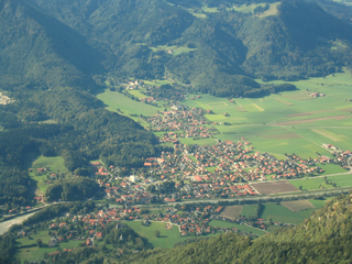
Reit im Winkl with Unterberg Wilder- and Zahmerkaiser
DEU Reit im Winkl COA.svg
Location of Reit im Winkl within Traunstein district
Reit im Winkl in TS.svgPettingNußdorfKienbergGrassauBergen
Germany adm location map.svg
Red pog.svg
Reit im Winkl
Bavaria location map.svg
Red pog.svg
Reit im Winkl
Coordinates: 47°41′N12°28′E / 47.683°N 12.467°E / 47.683; 12.467 Coordinates: 47°41′N12°28′E / 47.683°N 12.467°E / 47.683; 12.467
Country Germany
State Bavaria
Admin. region Oberbayern
District Traunstein
Subdivisions10 Ortsteile
Government
   Mayor (202026) Matthias Schlechter [1] (CSU)
Area
  Total70.99 km2 (27.41 sq mi)
Highest elevation
1,869 m (6,132 ft)
Lowest elevation
696 m (2,283 ft)
Population
 (2021-12-31) [2]
  Total7,036
  Density99/km2 (260/sq mi)
Time zone UTC+01:00 (CET)
  Summer (DST) UTC+02:00 (CEST)
Postal codes
83242
Dialling codes 08640
Vehicle registration TS
Website www.reitimwinkl.de

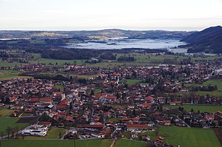
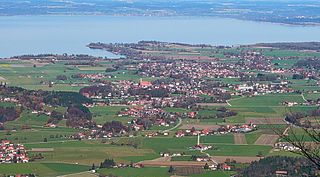
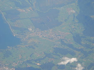
Reit im Winkl is a small village (locally known as a snow-magnet [3] ) located on the German/Austrian border in the southeastern part of Bavaria, Germany in the Traunstein district, and was previously an immigration and customs control point (prior to the formation of the Schengen Zone). It is situated south of Chiemsee and southwest of Ruhpolding – home of the Biathlon World Cup – in the Bavarian Alps and facing towards Tyrol. The village lies next to the Austrian states Tyrol and Salzburg. Kössen in Tyrol is the next village on the river Lofer, before it joins the confluence of the river Tiroler Achen. Reit im Winkl has a population of approximately 2,600.

Contents

Reit im Winkl is well known as both a certified place of restorative and curative air (Luftkurort) and a ski resort, offering alpine skiing, cross-country skiing, both classical and skating, and snow-boarding, as well as mountain trekking and hiking. It achieved, in 2012, Germany's first-ever Premium Winter Trails Certification. [4] Snowfall is always plentiful and predictable (even when surrounding areas are bare of snow, Reit im Winkl can be sure of sufficient snow to create premier skiing conditions – in 2012 Reit im Winkl had the deepest snow of 120 cm for a plateau area, [5] which occurred in February, long after snow had melted elsewhere in the region. Reit im Winkl has two alpine skiing areas: 1) Three lifts in the suburb of Blindau (Benzeck) as well as a snow-tubing lift, and the large plateau skiing area at Winklmoos Alm [6] which connects with Steinplatte in Austria and is reached by the recently completed, state-of-the-art gondola cableway (bubble lift) from Seegatterl.

In summer, Reit im Winkl enjoys one of the highest counts of sunny days in Bavaria, and is popular with mountain bike and nordic walking enthusiasts. Visitors can enjoy swimming in either of the three alpine lakes (Weitsee, Mittersee and Loedensee) northeast of Seegatterl, or try their luck at fishing in the trout lake.

Reit im Winkl is popularly known to locals and return visitors as Germany's own Tyrol, and boasts its own home-grown regional specialities such as Heumilch cheese (cheese made from cows fed exclusively hay pasture), heuschnapps (a liqueur in which mountain hay and herbs are soaked to produce a distinctive and sweet taste of hay) and Reiberdatschi (grated potatoes mixed with a little egg and flour and poured as a flat mass into a skillet and fried), popularly eaten with apple mousse.

Suburbs

Reit im Winkl is divided into the suburbs Birnbach, Blindau, Entfelden, Groissenbach, Oberbichl, Seegatterl, Unterbichl and Winklmoos Alm.

History

The first signs of settlement in Reit im Winkl are in the 12th century. The date of the foundation is 1160 when Otto de Rute was named in a document. The accuracy of the document is disputed and some historians put the beginning of the settlement to the middle of the 13th century. Since then it has been part of Bavaria.

Reit im Winkl was part of the parish of Kirchdorf in Tirol which was itself part of the diocese of Chiemsee from 1275 until 1804.

Historians have assumed the location of the manor of the Herren von Reit (Lords of Reit), on a small hill above the church.

Coat of arms

The coat of arms was created 1929 replacing the old coat of arms which showed a blue chapel on a green hill. The new coat of arms shows the eagle on yellow ground of the diocese of Chiemsee in a corner (Winkl derived from the German word Winkel for corner). The burning log and the sapie (axe like tool to trail logs) on the forest green ground are symbols for the clearing of the forest to create pasture and farm land in 11th and 12th century.

Economy

History

Formerly, Reit im Winkl was mostly dependent on logging and forestry, because of the brevity of the growing season for agricultural production. Trees were logged in summer and transported to storage places with horses or by hand. Logs were transferred to neighbouring Tyrol for sale: in winter either via sleds with a man sitting in front using his feet to brake and control the sled, which resulted in severe accidents occurring regularly, or via dams which were constructed to hold the meltwater during spring in order to raft the timber down the valley – such a dam can be found on display at Winklmoss Alm. Because the orientation of the valley made it impossible to sell the rafted wood to the salt works of Bad Reichenhall or Traunstein – which had an enormous fuel consumption – logs were sent south. In one such contract the wood was sold to the silver works in the Inn valley in Tyrol and as an exchange Tyrol sold logs to the salt works in Bad Reichenhall.

Today

The first tourist to Reit im Winkl, in the year 1858, was King Maximilian II, as reported in the local press. The Strength Through Joy movement in the Third Reich and the closed borders after the war boosted tourism as the principal source of income in the region. Today, approximately 5000 beds for annual visitor numbers of 90 000 provides an indication of the importance of tourism for Reit im Winkl.

Transport

German Alps Road (B 305), near Reit im Winkl, Germany German Alps Road (B 305), near Reit im Winkl, Germany.JPG
German Alps Road (B 305), near Reit im Winkl, Germany

Reit im Winkl is located along the Deutschen Alpenstraße (B 305) (German Alps Road). Coming from Munich by car it can be reached either from the Munich-Salzburg highway A8 at Bernau or Chiemsee and the Tiroler Achen valley; coming from Salzburg along the Munich-Salzburg A8 at Siegsdorf or Grabenstatt via Ruhpolding, or through Bad Reichenhall via Berchtesgarden. The Maserer pass (B305, direction Marquartstein) has been renovated and widened (most recently at the end of the 20th century) – during periods of heavy snowfall, snow chains are recommended. The B305 continues through the village, across the border into Austria and follows the river Lofer river to Kössen straight into the Inn valley. Because of the need for transport capacities for the sawmills and logs from the surrounding forest a narrow gauge railway was built from Ruhpolding to Reit im Winkl in 1923. Following accidents and as a result of the high maintenance costs (winter conditions) the railway was demolished in the 1930s. The causeway is used as a bicycle trail in summer and for nordic skiing in the winter.

Apart from private car, Reit im Winkl can be reached via public transport – the RVO (Regionalverkehr Oberbayern) runs the following bus services which also connect (in the case of Prien am Chiemsee, Salzburg and Traunstein) with the Deutsche Bahn (train services).

   1. 9505 – Reit im Winkl – Prien am Chiemsee    2. 9506 – Reit im Winkl – Inzell    3. 9507 – Reit im Winkl – Winklmoos    4. 9509 – Reit im Winkl – Traunstein    5. 9531 – Oberwössen – Übersee    6. 9535 – Reit im Winkl – Salzburg

Reit im Winkl also has one taxi service, a rental car service, and a minibus rental/coach with driver service.

Personalities

Sons and daughters of the community

Other personalities linked to Reit im Winkl

Related Research Articles

<span class="mw-page-title-main">Salzburg (state)</span> State of Austria

Salzburg is a state (Land) of the modern Republic of Austria. It is officially named Land Salzburg to distinguish it from its eponymous capital — the city of Salzburg. For centuries, it was an independent Prince-Bishopric of the Holy Roman Empire.

Berchtesgadener Land is a Landkreis (district) in Bavaria, Germany. It is bounded by the district of Traunstein and by the state of Austria.

Traunstein is a Landkreis (district) in the southeastern part of Bavaria, Germany. Neighboring districts are Mühldorf, Altötting, the Austrian states Upper Austria and Salzburg, the district Berchtesgadener Land, the Austrian states of Salzburg and Tyrol, and the district Rosenheim.

<span class="mw-page-title-main">Traunstein</span> Town in Bavaria, Germany

Traunstein is a town in the south-eastern part of Bavaria, Germany, and is the administrative center of a much larger district of the same name. The town serves as a local government, retail, health services, transport and educational center for the wider district.

<span class="mw-page-title-main">Saalach</span> River in Germany

The Saalach is a 105-kilometre-long (65 mi) river in Austria and Germany, and a left tributary of the Salzach.

<span class="mw-page-title-main">Bischofshofen</span> Place in Salzburg, Austria

Bischofshofen is a town in the district of St. Johann im Pongau in the Austrian federal state of Salzburg. It is an important traffic junction located both on the Salzburg-Tyrol Railway line and at the Tauern Autobahn, a major highway route crossing the main chain of the Alps.

<span class="mw-page-title-main">Marquartstein</span> Municipality in Bavaria, Germany

Marquartstein is a municipality in the southeastern part of Bavaria, Germany and is part of the Verwaltungsgemeinschaft Marquartstein and Staudach-Egerndach. It is situated in a region called Chiemgau, approximately 10 km south of Lake Chiemsee between Munich and Salzburg. Most of the area is situated in the valley of the river Tiroler Achen, which separates the village into two parts. Marquartstein is at the edge of the Alps. Its geographical location is 47°46′N12°28′E.

<span class="mw-page-title-main">Grassau, Bavaria</span> Municipality in Bavaria, Germany

Grassau is a market town in the district of Traunstein in Bavaria in Germany. It is located south of lake Chiemsee in the valley of the Tiroler Ache.

<span class="mw-page-title-main">Übersee</span> Municipality in Bavaria, Germany

Übersee is a municipality and a village in the rural district of Traunstein in upper Bavaria, Germany. It lies on the south shore of lake Chiemsee.

<span class="mw-page-title-main">Bernau am Chiemsee</span> Municipality in Bavaria, Germany

Bernau am Chiemsee is a municipality in the district of Rosenheim in Germany on the Lake Chiemsee, and a Luftkurort.

<span class="mw-page-title-main">Kössen</span> Place in Tyrol, Austria

Kössen is a municipality in the Kitzbühel district in the Austrian state of Tyrol located 24 km north of Kitzbühel as well as 15.50 km north of Sankt Johann in Tirol at the Kitzbühler Ache near the border to Germany.

<span class="mw-page-title-main">Weitsee</span> Body of water

Weitsee is a small lake on between Reit im Winkl and Ruhpolding with an area of 63.60 ha and a maximum depth of 9.30 m. The lake itself is separated into a shallow western and a deeper eastern part by a mountain peninsula. It is the first lake in the Dreiseengebiet followed by the Mittersee and Lödensee. The lakes are located in the valley between the Gurnwandkopf und Dürrnbachhorn next to the Deutsche Alpenstraße B305.

<span class="mw-page-title-main">Chiemgau Railway</span>

The Chiemgau Railway is a single-tracked, 9.6-kilometre-long (6.0 mi) railway line between Prien am Chiemsee and Aschau im Chiemgau in the state of Bavaria in southern Germany. It is timetabled as route no. 952.

<span class="mw-page-title-main">Großache</span> River in Germany

The Großache is a river, 79 kilometres (49 mi) long, in the east of the Austrian state of Tyrol and the Bavarian region of Chiemgau.

<span class="mw-page-title-main">Dürrnbachhorn</span>

Dürrnbachhorn is a mountain of Bavaria, Germany.

<span class="mw-page-title-main">Maria Hellwig</span>

Maria Hellwig was a German yodeler, popular performer of volkstümliche Musik, and television presenter.

<span class="mw-page-title-main">Deutsches Eck (transport link)</span>

The Deutsches Eck is the name given to the shortest and most convenient road and railway link between the Austrian metropolitan region of Salzburg and the Tyrolean Unterland with the state capital Innsbruck.

<span class="mw-page-title-main">Schwarzlofer</span> River in Germany

Schwarzlofer is a river of Tyrol, Austria and Bavaria, Germany. Its source is on the Schwarzloferalm, north of Waidring (Tyrol). It passes through Reit im Winkl (Bavaria) and flows into the Großache near Kössen (Tyrol).

The Rosenheim–Salzburg railway is a continuous double track and electrified main line railway almost entirely within the German state of Bavaria. It is an international transport corridor, linking Rosenheim to Salzburg in Austria.

References

  1. Liste der ersten Bürgermeister/Oberbürgermeister in kreisangehörigen Gemeinden, Bayerisches Landesamt für Statistik, 15 July 2021.
  2. "LSN-Online Regionaldatenbank, Tabelle A100001G: Fortschreibung des Bevölkerungsstandes, Stand 31. Dezember 2021" (in German). Landesamt für Statistik Niedersachsen.
  3. "Ferien auf der Hemmersuppenalm -an Deutschlands erstem Premium-Winterwanderweg: Zauberhaftes Schneeloch".
  4. "Reit im Winkl – Winterwandern auf Premium Winterwanderwegen". Archived from the original on 2013-01-27.
  5. "Deutschlandwetter im Jahr 2012".
  6. www.winklmoosalm.de