Bavarian Alps

Last updated
Bavarian Alps
Bayerische Alpen.JPG
View of the Mangfall Mountains from Bodenschneid looking west to the Wallberg
Highest point
Peak Zugspitze
Elevation 2,962 m (9,718 ft)
Coordinates 47°18′43″N10°21′22″E / 47.31194°N 10.35611°E / 47.31194; 10.35611
Naming
Native nameBayerische Alpen (German)
Geography
Countries Germany and Austria
States Bavaria and Tyrol/Vorarlberg
Range coordinates 47°38′N11°46′E / 47.64°N 11.77°E / 47.64; 11.77
Parent range Northern Limestone Alps
Borders on Western Rhaetian Alps, North Tyrol Limestone Alps and Northern Salzburg Alps
Geology
Orogeny Alpine orogeny

The Bavarian Alps (German : Bayerische Alpen) is a collective name for several mountain ranges of the Northern Limestone Alps within the German state of Bavaria.

Contents

Geography

Bavarian Alps, view from Murnau Murnauer Moos Marsh 3.jpg
Bavarian Alps, view from Murnau

The term in its wider sense refers to that part of the Eastern Alps that lies on Bavarian state territory. However, it is traditionally understood that the Bavarian Alps are only those ranges between the rivers Lech and Saalach ( Altbayern ). In this narrower sense, the Allgäu Alps in Swabia, which have only been part of Bavaria in more recent times, and the Berchtesgaden Alps in the east are not considered part of the Bavarian Alps.

The term is frequently used, but does not correspond to the common classification of the Eastern Alps (AVE) developed by the German, Austrian and South Tyrol Alpine Clubs. It should not be confused with the term Bavarian Prealps either. The latter only covers the Bavarian section of the Prealps between the River Loisach in the west and the River Inn in the east.

According to the Italian Partizione Delle Alpi classification, the Bavarian Alps (Alpi Bavaresi) comprise the Allgäu and Lechtal Alps as well as the adjacent Achen Lake mountains.

View from the Jenner over the Konigssee to Watzmann massif. Watzmann (Ostseite).jpg
View from the Jenner over the Königssee to Watzmann massif.

Early human settlement

A rising number of mega charcoal pieces dated to the Bronze Age suggests increased slash and burn activities, possibly linked to the creation of open space for pasturing. These results provide evidence of human interaction with the mountain environment, beginning in the Neolithic Age and clear evidence of mountain pasture use beginning during the Iron Age at 750 BC. Based on palynology and pedoanthracology it is however, difficult to clearly differentiate between pasturing, hunting and other human interactions with the environment. [1]

Notable summits

The Bavarian Alps in their broader sense include the following parts of the mountain ranges listed − in this tabular overview sorted according to AVE roughly from west to east and with maximum heights above sea level (NN). The highest peaks and elevations shown relate to that part of the mountain group that lies in Bavaria, and not to the overall group. For example, the highest mountain of the Allgäu Alps, the 2,657 m above sea level (AA) high Großer Krottenkopf, lies in Tyrol and is not shown in the table.

The highest peak in the Bavarian Alps and in Germany as a whole is the Zugspitze. It lies in the western part of the Wetterstein range and has a high Alpine character with its height of 2,962 m above NN as well as its two small glaciers.

By clicking on the word "List" in the various rows of the Lists column, a list other mountains in the particular range may be viewed (noting that some of them will be outside Bavaria or the Bavarian Alps). The table may be sorted by clicking on the sort symbols in the column headers.

Zugspitze Massif with the Zugspitze peak (left), the highest mountain in Germany (seen from the Fern Pass in Austria, looking northeast) Zugspitze-Schneefernerkpf1.jpg
Zugspitze Massif with the Zugspitze peak (left), the highest mountain in Germany (seen from the Fern Pass in Austria, looking northeast)
Range

Lists

Proportion
in Bavarian Alps
Highest peak
on Bavarian state territory
Height
Allgäu Alps List part Hochfrottspitze 2,649 m (8,691 ft)
Ammergau Alps List most Kreuzspitze 2,185 m (7,169 ft)
Wetterstein List part Zugspitze 2,962 m (9,718 ft)
Bavarian Prealps [2] List part Krottenkopf 2,086 m (6,844 ft)
Karwendel [3] List part Östliche Karwendelspitze 2,538 m (8,327 ft)
Chiemgau Alps List most Sonntagshorn 1,961 m (6,434 ft)
Berchtesgaden Alps List part Watzmann 2,713 m (8,901 ft)

Landscape

Like the Alps as a whole, the Bavarian Alps as part of the Northern Limestone Alps were heavily influenced by the last ice age. Cirques, lakes and typical U-shaped valleys were formed by the glaciers. Depositions by ice age rivers and glaciers left behind a gently rolling landscape in the Alpine Foreland with lakes and bogs.

Animal life in the region

Due to hunting and environmental shifts, many animals are just now being reintroduced into the habitat they once roamed. The continent's giant cat, the lynx, is one of those returnees. The lynx disappeared from the Bavarian Alps in the 19th century due to human persecution, along with predatory demands. A release project by Czech colleagues in the 1980s allowed for the lynx to have a second wind in the area, with the growth of the lynx population in the region. The gray wolf is the second giant predator and native to the Bavarian Forest. Like the lynx, the wolf was presumed extinct in the region, but due to conservation efforts and restraint on hunting in the area, they, too, are making a comeback.

Mammals such as wildcats, otters, or beavers inhabit the national park too.The region's most well-known bird is the capercaillie. The stocks of the capercaillie, which is quite rare in Germany, also decreased and nearly vanished in the Bavarian Forest during the 20th century. Although the bird was close to extinction, path regulations and sanctuaries helped to further their population growth.

The persecution of native animals in the region has been a long-time concern and issue along the Bavarian Alps. Now thanks to recent strides in conservation, many of these animals are being reintroduced into this habitat through park services such as the National Forest in Bavaria. [4]

Related Research Articles

<span class="mw-page-title-main">Carnic Alps</span> Mountain range in Austria and Italy

The Carnic Alps are a range of the Southern Limestone Alps in Austria and northeastern Italy. They are within Austrian East Tyrol and Carinthia, and Italian Friuli and marginally in Veneto.

<span class="mw-page-title-main">Noric Alps</span>

The Noric Alps is a collective term denoting various mountain ranges of the Eastern Alps. The name derives from the ancient Noricum province of the Roman Empire on the territory of present-day Austria and the adjacent Bavarian and Slovenian area.

<span class="mw-page-title-main">Alpine foothills</span> Index of articles associated with the same name

The Alpine foothills, or Prealps, may refer generally to any foothills at the base of the Alps in Europe. They are the transition zone between the High Alps and the Swiss Plateau and the Bavarian Alpine Foreland in the north, as well as to the Pannonian Basin (Alpokalja) in the east, the Padan Plain in the south and the Rhone Valley in the west.

<span class="mw-page-title-main">Allgäu Alps</span> Mountain range in the Northern Limestone Alps

The Allgäu Alps are a mountain range in the Northern Limestone Alps, located in Bavaria and Baden-Württemberg in Germany and Tyrol and Vorarlberg in Austria. The range lies directly east of Lake Constance.

<span class="mw-page-title-main">Alpine transhumance</span> Seasonal droving of grazing livestock between valleys in winter and high mountain pastures in summer

Alpine transhumance is transhumance as practiced in the Alps, that is, a seasonal droving of grazing livestock between the valleys in winter and the high mountain pastures in summer. Transhumance is a traditional practice that has shaped much of the landscape in the Alps, as without it, most areas below 2,000 m (6,600 ft) would be forests. While tourism and industry contribute today much to Alpine economy, seasonal migration to high pastures is still practiced in Bavaria, Austria, Slovenia, Italy, France and Switzerland, except in their most frequented tourist centers. In some places, cattle are taken care of by local farmer families who move to higher places. In others, this job is for herdsmen who are employees of the cooperative owning the pastures.

<i>Oeneis glacialis</i> Species of butterfly

Oeneis glacialis, the Alpine Grayling, is a butterfly of the family Nymphalidae. It is found in the Alps at heights of 1400 to 2900 m above sea level.

<span class="mw-page-title-main">Bavarian Prealps</span>

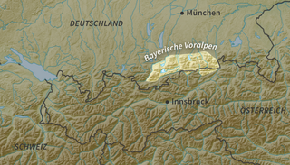
The Bavarian Prealps are a mountain range within the Northern Limestone Alps in south Germany. They include the Bavarian Prealp region between the river Loisach to the west and the river Inn to the east; the range is about 80 kilometres (50 mi) long and 20–30 kilometres (12–19 mi) wide. The term is not defined politically, but alpine-geographically because small areas of the Bavarian Prealps lie in Tyrol.

<span class="mw-page-title-main">Ammergau Alps</span>

The Ammergau Alps are a mountain range in the Northern Limestone Alps in the states of Bavaria (Germany) and Tyrol (Austria). They cover an area of about 30 x 30 km and begin at the outer edge of the Alps. The highest summit is the Daniel which has a height of 2,340 metres (7,680 ft).

<span class="mw-page-title-main">Hochvogel</span>

The Hochvogel is a 2,592-metre-high (8,504 ft) mountain in the Allgäu Alps. The national border between Germany and Austria runs over the summit. Although only the thirteenth highest summit in the Allgäu Alps, the Hochvogel dominates other parts of Allgäu Alps and the other ranges in the immediate neighbourhood. This is due to the fact that the majority of the higher peaks are concentrated in the central and western part of the Allgäu Alps. The Hochvogel stands on its own in the eastern part of the mountain group; the nearest neighbouring summits are 200 to 300 metres lower. Experienced climbers can ascend the summit on two marked routes.

<span class="mw-page-title-main">SOIUSA</span>

SOIUSA is a proposal for a new classification system of the Alps from the geographic and toponomastic point of view. It was designed by Sergio Marazzi, Italian researcher and author of the Orographic Atlas of the Alps SOIUSA. His book was presented with the patronage of the Italian Alpine Club on 23 Jan 2006, but has yet to receive any formal acceptance.

<span class="mw-page-title-main">Brandenberg Alps</span>

The Brandenberg Alps are a sub-group of the Northern Limestone Alps, that run in front of the Eastern Alps for their whole length. They lie entirely in Austria between Achensee in Tyrol, the Inn Valley and the Bavarian Prealps.

<span class="mw-page-title-main">Eastern Rhaetian Alps</span> Mountain range

The Eastern Rhaetian Alps are a mountain range in the central part of the Alps.

<span class="mw-page-title-main">Adelegg</span> Mountain range in Germany

The Adelegg is a forested, mountain range, up to 1,129 m above sea level (NN) and 112 km² in area, which is part of the northern foothills of the Alps, within the Westallgäu in the south German districts of Ravensburg and Oberallgäu.

<span class="mw-page-title-main">Tyrol Schistose Alps</span>

The Tyrol Schistose Alps is the proposed name for a subdivision of mountain ranges in a new, and as yet unadopted, classification of the Alps, located in Austria.

<span class="mw-page-title-main">North Tyrol Limestone Alps</span>

The North Tyrol Limestone Alps are a mountain range located in Austria and, marginally, in Germany.

<span class="mw-page-title-main">Carnic and Gailtal Alps</span>

The Carnic and Gailtal Alps is a geographic grouping of mountain ranges belonging to the Southern Limestone Alps. They are located in Austria and Italy.

<span class="mw-page-title-main">Partizione delle Alpi</span>

The Partizione delle Alpi is a classification of the mountain ranges of the Alps, that is primarily used in Italian literature, but also in France and Switzerland. It was devised in 1926.

<span class="mw-page-title-main">Bellunes Alps</span>

The Bellunes Alps is the now obsolete name of a mountain range on the southern edge of the Eastern Alps.

References

  1. Schäfer, Dieter (1998). "Zum Untersuchungsstand auf dem altmesolithischen Fundplatz vom Ullafelsen im Fotschertal (Stubaier Alpen, Tirol)". Germania: Anzeiger der Römisch-Germanischen Kommission des Deutschen Archäologischen Instituts. 76 (2): 439–496. ISSN   0016-8874.
  2. Bavarian Prealps subdivided into: Ester Mountains, Walchensee Mountains, Benediktenwand
    Group and Mangfall Mountains
  3. Karwendel: main part of the range lies in Austrian Tyrol
  4. "Animals of the Bavaria Forest National Park". www.nationalpark-bayerischer-wald.bayern.de. Retrieved 2023-05-08.

Sources