Glarus Alps

Last updated
Glarus Alps
Braunwald Alps.jpg
Glarus Alps from Braunwald
Highest point
PeakTödi
Elevation 3,614 m (11,857 ft)
Coordinates 46°48′40″N8°54′53″E / 46.81111°N 8.91472°E / 46.81111; 8.91472
Naming
Native nameGlarner Alpen (German)
Geography
Glarner Alpen Map.png
Country Switzerland
Cantons Glarus, Uri, Graubünden and St Gallen
Range coordinates 46°55.9′N8°54.9′E / 46.9317°N 8.9150°E / 46.9317; 8.9150
Parent range Western Alps
Borders on Uri Alps, Schwyz Alps, Appenzell Alps, Lepontine Alps and Western Rhaetian Alps
Topo map Swiss Federal Office of Topography swisstopo
Geology
Orogeny Alpine orogeny

The Glarus Alps (German : Glarner Alpen) are a mountain range in central Switzerland. They are bordered by the Uri Alps and the Schwyz Alps to the west, the Lepontine Alps to the south, the Appenzell Alps to the northeast. The eastern part of the Glarus Alps contains a major thrust fault that was declared a geologic UNESCO World Heritage Site (the Swiss Tectonic Arena Sardona).

Contents

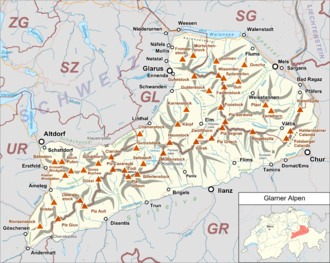
The Glarus Alps extend well beyond the canton of Glarus, including parts of the cantons of Uri, Graubünden, and St Gallen. Conversely, not all the mountains in the canton of Glarus are part of the Glarus Alps, with those to the north of the Urner Boden and to the west of the valley of the river Linth considered to be part of the Schwyz Alps.

Geography

The Bifertenstock above Lake Limmernsee Bifertenstock2.jpg
The Bifertenstock above Lake Limmernsee
Calfeisen valley Calfeisen.jpg
Calfeisen valley

The main chain of the Glarus Alps can be divided into six minor groups, separated from each other by passes, the lowest of which exceeds 7,500 ft. The westernmost of these is the Crispalt, a rugged range including many peaks of nearly equal height. The highest of these are the Piz Giuv (3,096 m) and Piz Nair. The name Crispalt is given to a southern, but secondary, peak of Piz Giuv, measuring 3,070 m. West of the main group is the Rienzenstock, while a northern outlier culminates in the Bristen. East of the Crispalt, the Chrüzli Pass separates this from the rather higher mass of the Oberalpstock (3,328 m). [1]

Here occurs a partial break in the continuity of the chain. The crest of the snowy range connecting the Oberalpstock with the Tödi nowhere sinks to 9,000 feet, but makes a sweep convex to the north, forming a semicircular recess, whose numerous torrents are all poured into the Rhine through the Val Russein below Disentis. Two glacier passes lead over this part of the chain — one to west, over the Brunnigletscher to the Maderanertal; the other to the north-east, over the Sand Glacier, to the Linthal. [1]

The massif of the Hausstock Hausstock und Ruchi.jpg
The massif of the Hausstock

The Tödi, the highest of the range and of north-eastern Switzerland (3,614 m), is attended by numerous secondary peaks that arise from the extensive snow-fields surrounding the central mountain. A very considerable outlyer, whose chief summits are the Schärhorn and the Gross Windgällen, belonging to the canton of Uri, is connected with the Tödi by the range of the Clariden Grat, north to the Hüfi Glacier. A less important branch encloses the Biferten Glacier, and terminates in the Selbsanft, south of Tierfehd. Towards the valley of the Vorderrhein a high promontory stretches nearly due south from the central peaks of the Tödi, and is crowned by the summit of the Piz Posta Biala. Another considerable ramification of the same mass terminates farther to the east in the peak of the Cavistrau. [1]

The Kisten Pass separates the Tödi group from the Hausstock, whose summit attains 3,158 m; a branch of this latter group forms the range of the Kärpf in the canton of Glarus. The Hausstock is cut off from the rather lower but more extended mass of the Vorab by the Panixer Pass (7,907 ft). Numerous summits, of which the Vorab proper and Piz Grisch are the most important, approach very near, but do not quite attain to 10,000 feet. [1]

The eastern limit of the latter group is marked by the Segnas Pass  [ de ] — the most frequented of those connecting the Canton Glarus with the Vorderrhein — beyond which arises a wide-stretching mass of rock and glacier, which is part of the Glarus thrust and culminates at Piz Sardona. This mass is cleft by a deep valley — the Calfeisental: one branch, culminating in the Pizol (2,844 m), extends east over Pfäfers, while another, including the highest peak of the canton of St. Gallen, the Ringelspitz (3,247 m), runs due east to the low Kunkels Pass (1,357 m), separating this range from the Calanda. [1]

Principal summits

Selbsanft and Todi Todi2.jpg
Selbsanft and Tödi
View from the summit of Fronalpstock GlarnerAlpen.jpg
View from the summit of Fronalpstock
NameAltitude
Piz Russein (Tödi)3,613 m (11,854 ft)
Bifertenstock 3,419 m (11,217 ft)
Piz Urlaun 3,358 m (11,017 ft)
Oberalpstock 3,328 m (10,919 ft)
Gross Schärhorn 3,297 m (10,817 ft)
Clariden 3,267 m (10,719 ft)
Gross Düssi 3,256 m (10,682 ft)
Cavistrau Grond 3,251 m (10,666 ft)
Ringelspitz 3,247 m (10,653 ft)
Gross Windgällen 3,192 m (10,472 ft)
Hausstock 3,152 m (10,341 ft)
Gross Ruchen 3,136 m (10,289 ft)
Tristelhorn 3,114 m (10,217 ft)
Ruchi 3,107 m (10,194 ft)
Piz Segnas 3,102 m (10,177 ft)
Piz Giuv 3,098 m (10,164 ft)
Muttenstock 3,089 m (10,135 ft)
Hinderi Schibe 3,083 m (10,115 ft)
Crispalt 3,080 m (10,105 ft)
Bristen 3,074 m (10,085 ft)
Piz Cazarauls 3,063 m (10,049 ft)
Hinter Selbsanft 3,028 m (9,934 ft)
Bündner Vorab 3,025 m (9,925 ft)
Crap Mats 2,947 m (9,669 ft)
Piz Avat 2,910 m (9,547 ft)
Nüschenstock 2,893 m (9,491 ft)
Piz Ner 2,859 m (9,380 ft)
Tschingelhörner 2,850 m (9,350 ft)
Piz Sol Grauehorner 2,849 m (9,347 ft)
Sazmartinshorn 2,827 m (9,275 ft)
Zanaihorn 2,821 m (9,255 ft)
Mättlenstöck 2,808 m (9,213 ft)
Calanda 2,805 m (9,203 ft)
Kärpf 2,797 m (9,177 ft)
Piz Alpetta 2,764 m (9,068 ft)
Piz Dado 2,699 m (8,855 ft)
Hangsackgrat 2,634 m (8,642 ft)
Alpler Torstock 2,622 m (8,602 ft)
Fahnenstock 2,612 m (8,570 ft)
Schijen 2,610 m (8,563 ft)
Magerrain 2,528 m (8,294 ft)
Blistock 2,448 m (8,031 ft)
Mürtschenstock 2,442 m (8,012 ft)
Hochfinsler 2,423 m (7,949 ft)
Fil da Rueun 2,351 m (7,713 ft)
Chratzerengrat 2,349 m (7,707 ft)
Hochmättli 2,252 m (7,388 ft)
Fläschenspitz 2,073 m (6,801 ft)

Glaciers

Main glaciers  :

Passes

Oberalppass, eastern rise Oberalppass Ostrampe.jpg
Oberalppass, eastern rise

The chief passes of the Tödi Range, from the Oberalp Pass to the Klausen Pass, are: [2]

Note: road status as of 1911.
Mountain passLocationType (as of 1911)Elevation
Clariden Pass, Hüfi Pass Maderanertal to Linthal snow2,942 m (9,652 ft)
PlanuraMaderanertal to Linthalsnow2,921 m (9,583 ft)
ChammlilückeMaderanertal to Unterschächen snow2,833 m (9,295 ft)
Sardona Pass Flims to Vättis snow2,757 m (9,045 ft)
Sand Alp Pass Disentis to Linthalsnow2,780 m (9,121 ft)
Brunni PassDisentis to Maderanertalsnow2,721 m (8,927 ft)
Segnas Pass  [ de ] Elm to Flims footpath2,625 m (8,612 ft)
Kisten Pass or Pass-LembraLinthal to Breil/Brigels bad bridle path2,501 m (8,205 ft)
Panixer Pass Elm to Pigniu bad bridle path2,407 m (7,897 ft)
Chrüzli Pass Maderanertal to Sedrun footpath2,346 m (7,697 ft)
Foo Pass Elm to Weisstannen bridle path2,222 m (7,290 ft)
Oberalp Pass Andermatt to Disentiscarriage road2,044 m (6,706 ft)
Klausen Pass Altdorf to Linthalcarriage road1,948 m (6,391 ft)

See also

Related Research Articles

<span class="mw-page-title-main">Swiss Alps</span> Portion of the Alps that lies within Switzerland

The Alpine region of Switzerland, conventionally referred to as the Swiss Alps, represents a major natural feature of the country and is, along with the Swiss Plateau and the Swiss portion of the Jura Mountains, one of its three main physiographic regions. The Swiss Alps extend over both the Western Alps and the Eastern Alps, encompassing an area sometimes called Central Alps. While the northern ranges from the Bernese Alps to the Appenzell Alps are entirely in Switzerland, the southern ranges from the Mont Blanc massif to the Bernina massif are shared with other countries such as France, Italy, Austria and Liechtenstein.

<span class="mw-page-title-main">Tödi</span> Mountain in Switzerland

The Tödi, is a mountain massif and with the mountain peak Piz Russein the highest mountain in the Glarus Alps and the highest summit in the canton of Glarus, Switzerland. It is located on the border between the cantons of Graubünden, to the south, and Glarus, to the north, close to the point where those two cantons meet the canton of Uri, to the west. Although not the culminating point of Graubünden, it is its highest peak outside the Bernina range.

<span class="mw-page-title-main">Vorderrhein</span> River in Canton of Graubünden, Switzerland

The Vorderrhein is one of the two sources of the Rhine. Its catchment area of 1,512 square kilometres is located predominantly in the canton of Graubünden (Switzerland). The Vorderrhein is about 76 kilometres (47 mi) long, thus more than 5% longer than the Hinterrhein. The Vorderrhein, however, has an average water flow of 53.8 m3/s (1,900 cu ft/s), which is less than the flow of the Hinterrhein. According to the Atlas of Switzerland of the Swiss Federal Office of Topography, the source of the Vorderrhein—and thus of the Rhine—is located north of the Rein da Tuma and Lake Toma.

<span class="mw-page-title-main">Glärnisch</span> Mountain in Switzerland

The Glärnisch is a mountain massif of the Schwyz Alps, overlooking the valley of the Linth in the Swiss canton of Glarus. It consists of several summits, of which the highest, Bächistock, is 2,915 metres above sea level. Until 2013, the highest point was considered to be an unnamed point with a summit cross at 2,914 metres. The other main summits are Vrenelisgärtli and the Ruchen.

<span class="mw-page-title-main">Uri Alps</span> Mountain range in central Switzerland

The Uri Alps are a mountain range in Central Switzerland and part of the Western Alps. They extend into the cantons of Obwalden, Valais, Bern, Uri and Nidwalden and are bordered by the Bernese Alps and the Emmental Alps to the west, the Schwyzer Alps to the north, the Lepontine Alps to the south and the Glarus Alps to the east (Reuss).

<span class="mw-page-title-main">Bifertenstock</span> Mountain in Switzerland

The Bifertenstock is a mountain in the Glarus Alps, located at an elevation of 3,419 m (11,217 ft) on the border between the cantons of Glarus (north) and Graubünden (south), its peak, however, is located about 25 metres south of the border. It overlooks four valleys: the valley of the Biferten Glacier to the north-west, the Griess Glacier to the north-east, the Val Punteglias to the south, which leads down to Trun, and the Val Frisal on the south-east. Glaciers cover both sides of the mountain, but are smaller on the southern side.

<span class="mw-page-title-main">Ringelspitz</span> Mountain in Switzerland

The Ringelspitz is a mountain of the Glarus Alps, located on the border between the Swiss cantons of St. Gallen and Graubünden. Reaching a height of 3,248 metres above sea level, it is the highest summit in the canton of St. Gallen. It is split between three municipalities: Pfäfers, Trin and Tamins (Graubünden).

<span class="mw-page-title-main">Oberalpstock</span> Mountain in Switzerland

The Oberalpstock or Piz Tgietschen is a mountain in the Glarus Alps between the cantons of Uri and Graubünden. Its massif separates the valleys of Maderanertal (Uri) and Surselva near Sedrun (Graubündnen).

<span class="mw-page-title-main">Piz Giuv</span> Mountain in Switzerland

Piz Giuv is a mountain of the Glarus Alps, located on the border between the cantons of Uri and Graubünden. At 3,096 metres above sea level, it is the highest mountain of the Glarus Alps lying west of the Oberalpstock. Its summit is situated between three valleys: the Fellital and Etzlital on the north side and the Val Giuv (Surselva) on the south side. The slightly lower Piz Nair lies on its east side

<span class="mw-page-title-main">Hausstock</span> Mountain in Switzerland

The Hausstock is a mountain in the Glarus Alps, at an elevation of 3,158 m (10,361 ft) on the border between the cantons of Glarus and Graubünden. It overlooks the valleys of Linth and Sernf rivers in Glarus, and the valley of the Vorderrhein river in Graubünden. The Hausstock was the site of the 1799 withdrawal of the Russian army under General Alexander Suvorov. A well-known destination already in the nineteenth century with British and American climbers, the mountain remains popular with mountain climbers and skiers.

<span class="mw-page-title-main">Piz Ault</span> Mountain in Switzerland

Piz Ault is a mountain of the Glarus Alps, located south of the Oberalpstock in Switzerland.

<span class="mw-page-title-main">Vorab</span> Mountain in Switzerland

The Vorab is a mountain of the Glarus Alps, located on the border between the cantons of Glarus and Graubünden. The summit is also named Bündner Vorab to distinguish it from a lower summit named Glarner Vorab. A glacier runs down its eastern face where the valley continues a moderate inclination down towards Flims, where it can be seen for example from Caumasee. It cannot be seen from the adjacent municipalities on the south though. The northwestern face however consists of a sheer drop towards Elm.

<span class="mw-page-title-main">Piz Sardona</span> Mountain in Switzerland

Piz Sardona is a mountain in the Glarus Alps, on the border between the cantons Glarus and St. Gallen. The 3,056 metre high mountain overlooks the valleys of Elm (Glarus) and Calfeisen. Less than one kilometre south of the summit lies the tripoint between the cantons of Glarus, St. Gallen and Graubünden. The summit itself is the northernmost point above 3,000 metres in Switzerland.

<span class="mw-page-title-main">Foostock</span> Mountain in Switzerland

The Foostock, also known as the Ruchen, is a mountain of the Glarus Alps, located on the border between the Swiss cantons of Glarus and St. Gallen. It lies north of Piz Sardona, on the range that separates the Sernftal from the Weisstannental.

<span class="mw-page-title-main">Piz Dolf</span> Mountain in Switzerland

Piz Dolf (Romansh) or Trinserhorn (German) is a mountain of the Glarus Alps, located on the border between the cantons of St. Gallen and Graubünden.

<span class="mw-page-title-main">Val Russein</span>

The Val Russein is a valley of the Swiss Alps, located south of the Tödi Group in Graubünden. The valley is drained by the Aua da Russein, a tributary of the Vorderrhein, near Cumpadials. The Val Russein belongs to the municipalities of Disentis and Sumvitg.

<span class="mw-page-title-main">Maderanertal</span>

The Maderanertal is an Alpine valley of the canton of Uri in Central Switzerland. It is drained by the Chärstelenbach, a stream that is a right tributary of the Reuss at Amsteg. The highest mountain in the Maderanertal is the Oberalpstock with a height of 3,328 metres above sea level. Other important summits are the Schärhorn, the Clariden, the Düssi, the Gross Windgällen, the Gross Ruchen, Piz Giuv and the Bristen.

Piz Cambrialas is a mountain of the Glarus Alps, overlooking the Val Russein in the Swiss canton of Graubünden.

<span class="mw-page-title-main">Sazmartinshorn</span> Mountain in Switzerland

The Sazmartinshorn is a mountain of the Glarus Alps, overlooking St. Martin and the lake of Gigerwald in the canton of St. Gallen. It lies on the range east of Piz Sardona, that separates the Weisstannental from the Calfeisental. After the Pizol, the Sazmartinshorn is the second highest mountain lying entirely within the canton of St. Gallen.

The Hangsackgrat is a mountain of the Glarus Alps, located south of Weisstannen in the canton of St. Gallen. It lies on the range east of Piz Sardona, that separates the Weisstannental from the Calfeisental.

References

  1. 1 2 3 4 5 John Ball, The Alpine Guide, Central Alps, 1866, London
  2. Lake, Philip (1911). "Alps"  . In Chisholm, Hugh (ed.). Encyclopædia Britannica . Vol. 1 (11th ed.). Cambridge University Press. p. 744.

Maps