Related Research Articles

The Alpine region of Switzerland, conventionally referred to as the Swiss Alps, represents a major natural feature of the country and is, along with the Swiss Plateau and the Swiss portion of the Jura Mountains, one of its three main physiographic regions. The Swiss Alps extend over both the Western Alps and the Eastern Alps, encompassing an area sometimes called Central Alps. While the northern ranges from the Bernese Alps to the Appenzell Alps are entirely in Switzerland, the southern ranges from the Mont Blanc massif to the Bernina massif are shared with other countries such as France, Italy, Austria and Liechtenstein.

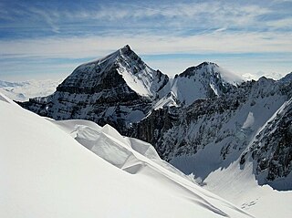
The Glarus Alps are a mountain range in central Switzerland. They are bordered by the Uri Alps and the Schwyz Alps to the west, the Lepontine Alps to the south, the Appenzell Alps to the northeast. The eastern part of the Glarus Alps contains a major thrust fault that was declared a geologic UNESCO World Heritage Site.

The Tödi, is a mountain massif and with the mountain peak Piz Russein the highest mountain in the Glarus Alps and the highest summit in the canton of Glarus, Switzerland. It is located on the border between the cantons of Graubünden, to the south, and Glarus, to the north, close to the point where those two cantons meet the canton of Uri, to the west. Although not the culminating point of Graubünden, it is its highest peak outside the Bernina range.

The Linth is a Swiss river that rises near the village of Linthal in the mountains of the canton of Glarus, and eventually flows into the Obersee section of Lake Zurich. It is about 50 kilometres (31 mi) in length.

The Alps form a large mountain range dominating Central Europe, including parts of Italy, France, Switzerland, Liechtenstein, Austria, Slovenia, Germany and Hungary.

The Grison Alps are the mountains of the Graubünden canton of Switzerland. There are many significant peaks in the Grison Alps, including the Tödi and the highest peak, Piz Bernina. Many of the mountain ranges feature extensive glaciers, such as at the Adula, the Albula, the Silvretta, the Bernnina or the Rätikon range. The Grison Alps include parts of both the Eastern Alps and the Western Alps. The Eastern Alps located in Graubünden are the Rhaetian Alps, which is part to the Central Eastern Alps.

The Glärnisch is a mountain massif of the Schwyz Alps, overlooking the valley of the Linth in the Swiss canton of Glarus. It consists of several summits, of which the highest, Bächistock, is 2,915 metres above sea level. Until 2013, the highest point was considered to be an unnamed point with a summit cross at 2,914 metres. The other main summits are Vrenelisgärtli and the Ruchen.
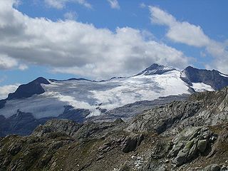
The Bifertenstock is a mountain in the Glarus Alps, located at an elevation of 3,419 m (11,217 ft) on the border between the cantons of Glarus (north) and Graubünden (south), its peak, however, is located about 25 metres south of the border. It overlooks four valleys: the valley of the Biferten Glacier to the north-west, the Griess Glacier to the north-east, the Val Punteglias to the south, which leads down to Trun, and the Val Frisal on the south-east. Glaciers cover both sides of the mountain, but are smaller on the southern side.

The Clariden is a mountain in the Glarus Alps, located at an elevation of 3,267 m (10,719 ft) between the Swiss cantons of Uri and Glarus. While on the north the Clariden overlooks the 1,948 m (6,391 ft) high Klausen Pass, the south side is covered by large glaciers. The Hüfifirn on the west is drained by the Chärstelenbach, a tributary of the Reuss that eventually flows into Lake Lucerne. The Claridenfirn on the east is drained by the Linth that eventually flows into Lake Zürich.

The Ruchi is a mountain in the Glarus Alps, located at an elevation of 3,107 m (10,194 ft) on the border between the Swiss cantons of Glarus and Graubünden. It overlooks the Muttsee on its west side from where a trail leads to the summit. On its south-east side lies a small glacier, the Glatscher da Gavirolas. The Ruchi is connected to the higher summit of the Hausstock on the north-east by a 2 km (1.2 mi) long ridge.

The Allalin Glacier is a 6 km (3.7 mi) long glacier (2005) situated in the Pennine Alps near the Allalinhorn in the canton of Valais in Switzerland. In 1973 it had an area of 9.9 km2 (3.8 sq mi). The glacier is bordered on the west by the Allalinhorn, Rimpfischhorn and Strahlhorn. It is not to be confused with the Fee Glacier which lies on the northern flank of Allalinhorn.
The Ferpècle Glacier is a 6.5 km (4.0 mi) long glacier (2005) situated in the Pennine Alps in the canton of Valais in Switzerland. In 1973 it had an area of 9.8 km2 (3.8 sq mi).
The Tsijiore Nouve Glacier is a 4 km (2.5 mi) long glacier (2005) situated in the Pennine Alps in the canton of Valais in Switzerland. In 1973 it had an area of 3.2 km2 (1.2 sq mi).

The Wildstrubel Glacier is a 2.5 km (1.6 mi) long glacier (2005) situated in the Bernese Alps in the canton of Valais, on the eastern slopes of the Wildstrubel. In 1973 it had an area of 4.8 km2 (1.9 sq mi)

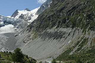
The Biferten Glacier is a 4-kilometre-long (2.5 mi) glacier (2005) situated in the Glarus Alps in the canton of Glarus in Switzerland. In 1973 it had an area of 2.81 square kilometres (1.08 sq mi). The glacier is located east of the Tödi.

The Hüfi Glacier is a 7 km (4.3 mi) long glacier (2005) situated in the Glarus Alps in the canton of Uri in Switzerland. In 1973 it had an area of 13.64 km2 (5.27 sq mi).
The Basòdino Glacier was a 1.5 km long glacier (2005) situated in the Lepontine Alps in the canton of Ticino in Switzerland. In 1973 it had an area of 2.31 km2. Its funeral, marking its inevitable demise, was held on 12 September 2021.

The Eiger Glacier is a glacier situated on the north-west side of the Eiger in the Bernese Alps of Switzerland. The glacier is within the municipality of Lauterbrunnen in the canton of Bern.

The Rossbode Glacier is a 3.5 km long glacier (2005) situated in the Pennine Alps in the canton of Valais in Switzerland. In 1973 it had an area of 1.87 km2.
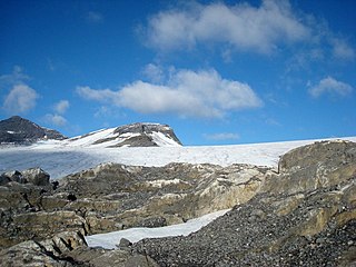
The Vorab Glacier is a 2 km long glacier situated in the Glarus Alps in the cantons of Glarus and Graubünden. It lies on the east side of the Vorab, between 2,600 and 3,000 metres above sea level. In 1973 it had an area of 2.17 km2., and is receding today.
References
- ↑ map.geo.admin.ch (Map). Swiss Confederation. Retrieved 2015-06-04.