Uri Alps

Last updated
Uri Alps
Dammastock.jpg
The Dammastock from the Göscheneralp
Highest point
PeakDammastock
Elevation 3,630 m (11,910 ft)
Coordinates 46°38′28″N8°25′6″E / 46.64111°N 8.41833°E / 46.64111; 8.41833
Naming
Native nameUrner Alpen (German)
Geography
Urner Alpen.png
CountrySwitzerland
Cantons Bern, Obwalden, Valais, Uri and Nidwalden
Parent range Western Alps
Borders on Bernese Alps, Emmental Alps, Schwyzer Alps, Glarus Alps and Lepontine Alps
Topo map Swiss Federal Office of Topography swisstopo

The Uri Alps (also known as Urner Alps, German : Urner Alpen) are a mountain range in Central Switzerland and part of the Western Alps. They extend into the cantons of Obwalden, Valais, Bern, Uri and Nidwalden and are bordered by the Bernese Alps (Grimsel Pass) and the Emmental Alps to the west (the four lakes: Lungerersee, Sarnersee, Wichelsee, and Alpnachersee), the Schwyzer Alps to the north (Lake Lucerne), the Lepontine Alps to the south (the valley of Urseren with Andermatt) and the Glarus Alps to the east (Reuss).

Contents

The Uri Alps are composed of two distinct groups separated by the Susten Pass. The Dammastock massif on the south is the most glaciated part while the northern part, which culminates on Titlis, has lower summits but greater extent.

Geography

The group south of the Susten Pass forms the dividing range between the head waters of the Aare (west) from those of the Reuss. In addition a small portion of the range (south-west) is located in the basin of the Rhone. This part lies entirely within the valley of the Rhone Glacier. This group forms a complex mass including four considerable ridges and attains its greatest height at the Dammastock and the Galenstock. The group includes four nearly parallel ridges running NNW. and SSE. That forming the eastern boundary of the valley of Hasli reaches 3,383 metres at the Tieralplistock, whence it extends NNW. to the Mährenhorn, and south to the Gärstenhörner. A wide reservoir of snow whence the Trift Glacier flows to the north and the Rhone Glacier to the south, divides this range from the more easterly range whose highest point is the Dammastock. North of the Dammastock the range collectively known as the Hinter Tierberg, attains 3,447 metres. Further east than the last is the Sustenhorn range, rising at its highest point to 3,505 metres, divided from the last by the Stein Glacier and the upper part of the Göschenental. Lastly, another ridge still further east is separated from the last by the Voralptal, a branch of the Göschenental. Its highest summits are the Fleckistock and the Stucklistock. The lower part of the Göschenental is bounded on the south by a range running west to east diverging from the ridge between the Dammastock and the Galenstock. [1]

On the north side of the Susten Pass the ranges are lower and, except the highest mountains on the south, free of glaciers. The main ridge, culminating at the Titlis divides the basins of the Aare and the Reuss. From the Grassen, tripoint border between the cantons of Bern, Obwalden and Uri, a small range diverges from the main watershed and runs from west to east and culminates at the Gross Spannort.

Principal summits

Sustenhorn Stucklistock-Griessenhorner.jpg
Sustenhorn
Hinter Tierberg Hintertierberg.jpg
Hinter Tierberg
Lochberg Lochberg.jpg
Lochberg
View from above Goscheneralpsee Goschenertal.jpg
View from above Göscheneralpsee
Trift Glacier 6085-6088 - Gadmertal - Triftbrucke.jpg
Trift Glacier

The principal summits of the Uri Alps are:

  1. Dammastock, 3630 m
  2. Schneestock, 3608 m
  3. Rhonestock, 3588 m
  4. Galenstock, 3586 m
  5. Eggstock, 3556 m
  6. Tiefenstock, 3515 m
  7. Sustenhorn, 3502 m
  8. Hinter Tierberg, 3447 m
  9. Gwächtenhorn, 3420 m
  10. Mittlerer Tierberg, 3418 m
  11. Fleckistock, 3416 m
  12. Maasplanggstock, 3401 m
  13. Wysse Nollen, 3398 m
  14. Diechterhorn, 3389 m
  15. Tieralplistock, 3382 m
  16. Chli Sustenhorn, 3318 m
  17. Vorderes Sustenlimihorn, 3316 m
  18. Stucklistock, 3308 m
  19. Gletschhorn, 3305 m
  20. Titlis, 3238 m
  21. Rorspitzli, 3220 m
  22. Sidelenhorn, 3217 m
  23. Gwächtenhorn, 3214 m
  24. Brunnenstock, 3210 m
  25. Chüeplanggenstock, 3207 m
  26. Gross Bielenhorn, 3207 m
  27. Voralphorn, 3203 m
  28. Winterstock, 3203 m
  29. Chelenalphorn, 3202 m
  30. Gross Griessenhorn, 3202 m
  31. Gross Spannort, 3198 m
  32. Hinteres Sustenlimihorn, 3194 m
  33. Gärstenhörner, 3189 m
  34. Limistock, 3189 m
  35. Tällistock, 3185 m
  36. Rotstock, 3183 m
  37. Hoch Horefellistock, 3175 m
  38. Gross Furkahorn, 3169 m
  39. Winterberg, 3167 m
  40. Chli Spannort, 3140 m
  41. Hinter Schloss (Schlossberg), 3132 m
  42. Steinhüshorn, 3121 m
  43. Chilchlistock, 3114 m
  44. Krönten, 3107 m
  45. Hintere Gelmerhörner, 3100 m
  46. Vorderer Tierberg, 3091 m
  47. Zwächten, 3078 m
  48. Lochberg, 3074 m
  49. Müeterlishorn, 3066 m
  50. Wendenstöcke, 3042 m
  51. Blauberg, 3039 m
  52. Triftstöckli, 3035 m
  53. Klein Titlis, 3028 m
  54. Klein Furkahorn, 3026 m
  55. Wendenhorn, 3023 m
  56. Spitzli, 3011 m
  57. Bächenstock, 3008 m
  58. Reissend Nollen, 3003 m
  59. Mittagstock, 2,989 m
  60. Giglistock, 2900 m
  61. Engelberger Rotstock, 2818 m
  62. Radlefshorn, 2603 m
  63. Hochstollen, 2481 m
  64. Wandelen, 2105 m

Glaciers

Main glaciers  :

Related Research Articles

<span class="mw-page-title-main">Lepontine Alps</span> Mountain range in southern Switzerland and northern Italy

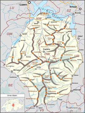
The Lepontine Alps are a mountain range in the north-western part of the Alps. They are located in Switzerland and Italy.

<span class="mw-page-title-main">Bernese Alps</span> Part of the Alps mountain range in Switzerland

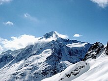
The Bernese Alps are a mountain range of the Alps, located in western Switzerland. Although the name suggests that they are located in the Berner Oberland region of the canton of Bern, portions of the Bernese Alps are in the adjacent cantons of Valais, Fribourg and Vaud, the latter being usually named Fribourg Alps and Vaud Alps respectively. The highest mountain in the range, the Finsteraarhorn, is also the highest point in the canton of Bern.

<span class="mw-page-title-main">Lake Lucerne</span> Lake in Central Switzerland

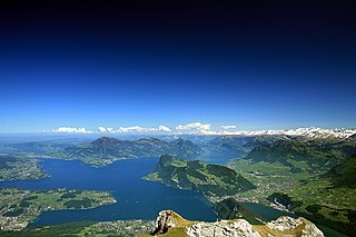
Lake Lucerne is a lake in central Switzerland and the fourth largest in the country.

<span class="mw-page-title-main">Engelberg</span> Municipality in Obwalden, Switzerland

Engelberg is a village resort and a municipality in the canton of Obwalden in Switzerland. Alongside the central village of Engelberg, the municipality encompasses additional settlements, including Grafenort, Oberberg and Schwand.

<span class="mw-page-title-main">Reuss (river)</span> River in Switzerland

The Reuss is a river in Switzerland. With a length of 164 kilometres (102 mi) and a drainage basin of 3,426 square kilometres (1,323 sq mi), it is the fourth largest river in Switzerland. The upper Reuss forms the main valley of the canton of Uri. The course of the lower Reuss runs from Lake Lucerne to the confluence with the Aare at Brugg and Windisch.

<span class="mw-page-title-main">Grimsel Pass</span> Mountain pass in Switzerland through the Bernese Alps

The Grimsel Pass is a mountain pass in Switzerland, crossing the Bernese Alps at an elevation of 2,164 metres (7,100 ft). The pass connects the Haslital, the upper valley of the river Aare, with the upper valley of the Rhône. In so doing, and as the Aare is a tributary of the Rhine, the pass crosses the continental divide between the North Sea and the Mediterranean Sea.

<span class="mw-page-title-main">Bernese Oberland</span> Higher part of the canton of Bern, Switzerland

The Bernese Oberland, sometimes also known as the Bernese Highlands, is the highest and southernmost part of the canton of Bern. It is one of the canton's five administrative regions. It constitutes the Alpine region of the canton and the northern side of the Bernese Alps, including many of its highest peaks, among which the Finsteraarhorn, the highest in both range and canton.

<span class="mw-page-title-main">Titlis</span> Mountain of the Uri Alps

Titlis is a mountain of the Uri Alps, located on the border between the cantons of Obwalden and Bern. At 3,238 metres (10,623 ft) above sea level, it is the highest summit of the range north of the Susten Pass, between the Bernese Oberland and Central Switzerland. It is mainly accessed from Engelberg (OW) on the north side and is famous as the site of the world's first rotating cable car. The cable car system connects Engelberg to the summit of Klein Titlis through the three stages of Gerschnialp, Trübsee and Stand. In 2016, a direct route was created that bypassed Geraschnialp, going directly to Trübsee.

<span class="mw-page-title-main">Oberhasli</span> Talschaft in Switzerland

The Oberhasli is a historical Landvogtei or Talschaft in the Bernese Highlands, Switzerland, bordering on the cantons of Obwalden (OW), Nidwalden (NW), Uri (UR) and Wallis (VS).

<span class="mw-page-title-main">Dammastock</span> Mountain in Switzerland

The Dammastock is the highest mountain in the Urner Alps in Switzerland and is part of the Winterberg massif. Its summit ridge forms the border between the cantons of Uri and the Valais. It is the highest summit in the canton of Uri. The tripoint between the cantons of Bern, Valais and Uri lies near the Eggstock, north of the Dammastock. Politically, the Dammastock is split between the municipalities of Göschenen (Uri) and Obergoms (Valais).

<span class="mw-page-title-main">Gross Windgällen</span> Mountain in Switzerland

The Gross Windgällen is a 3,187 m high mountain in the Glarus Alps, overlooking the valley of the Reuss in the canton of Uri. The name Gross Windgällen derives from Gälle or gellen, meaning as much as wailing, shrilling or whistling.

<span class="mw-page-title-main">Sustenhorn</span> Mountain in the Uri Alps, Switzerland

The Sustenhorn is a 3,502-metre-high (11,490 ft) mountain in the Uri Alps, located on the border between the cantons of Bern and Uri. It overlooks Susten Pass from the south.

<span class="mw-page-title-main">Gross Spannort</span> Mountain in Switzerland

The Gross Spannort is a mountain of the Uri Alps, located between Engelberg and Erstfeld in Central Switzerland. It is located within the canton of Uri, although its summit lies on the watershed between the Engelberger Aa and the main Reuss valley. The Gross Spannort is almost entirely surrounded by glaciers, the largest being the Glatt Firn. South-west of the Gross Spannort is the Chli Spannort.

<span class="mw-page-title-main">Klein Furkahorn</span> Mountain in Switzerland

The Klein Furkahorn is a mountain of the Urner Alps, overlooking the Furka Pass on the border between the Swiss cantons of Valais and Uri. It lies near the southern end of the Galenstock-Gross Furkahorn chain, east of the Rhone Glacier.

<span class="mw-page-title-main">Hinter Tierberg</span> Mountain in Switzerland

The Hinter Tierberg is a 3,445 metres high mountain in the Uri Alps, located on the border between the cantons of Bern and Uri. It overlooks the Trift Glacier on its west side and the Chelen Glacier on its east side.

<span class="mw-page-title-main">Fleckistock</span> Mountain in Switzerland

The Fleckistock is a 3,417 metres high mountain in the Urner Alps, overlooking Wassen in the canton of Uri. It is the highest summit of the group lying east of the pass of Sustenjoch. This range, starting at the Stucklistock and ending at the Salbitschijen, separates the valleys of Voralp, above Göschenen and Meiental, above Wassen.

<span class="mw-page-title-main">Düssi</span> Mountain in Switzerland

The Düssi is a mountain in the Glarus Alps in central Switzerland, located on the border between the cantons of Uri and Graubünden. Its massif separates the valleys of Maderanertal (Uri) and Val Russein (Graubünden). The summit is also named Gross Düssi to distinguish it from a lower summit to the south named Chli Düssi.

The Grassengrat is a multi-summited mountain of the Urner Alps, located on the border between the cantons of Obwalden and Uri in Central Switzerland. It lies on the range between the Titlis and the Gross Spannort. The main summit has an elevation of 2,941 metres and is named Stössenstock.

<span class="mw-page-title-main">Ruchstock</span> Mountain in Switzerland

The Ruchstock is a mountain of the Urner Alps in Central Switzerland.

<span class="mw-page-title-main">Muttenhorn</span> Mountain in Switzerland

The Muttenhorn is a mountain in the Lepontine Alps, located on the border between the cantons of Valais and Uri. At 3,099 metres above sea level, it overlooks the south side of Furka Pass. A glacier named Muttgletscher lies over its north-western flanks, above 2,600 metres.

References

  1. John Ball, The Alpine guide, Central Alps, p. 129, 1866, London