Kerns is a village in the canton of Obwalden in Switzerland.
Walter Fürst was a legendary Swiss patriot from Uri, who contributed to establish the liberty and independence of Switzerland. According to Tschudi he represented Uri at the Rütlischwur.

AegidiusTschudi was a Swiss statesman and historian, an eminent member of the Tschudi family of Glarus, Switzerland. His best known work is the Chronicon Helveticum, a history of the early Swiss Confederation.

Kuifje – De Zonnetempel, subtitled De Musical, is a 2001 Belgian musical in two acts with music by Dirk Brossé, lyrics and scenario by Seth Gaaikema and Frank van Laecke, based on two of The Adventures of Tintin by Hergé: The Seven Crystal Balls (1948) and Prisoners of the Sun (1949). It premièred in Antwerp in September 2001 in Dutch, and was translated into French and premièred a year later in Charleroi as Tintin – Le Temple du Soleil.

The Rütlischwur is the legendary oath taken at the foundation of the Old Swiss Confederacy by the representatives of the three founding cantons, Uri, Schwyz and Unterwalden, traditionally dated to 1307. It is named after the site of the oath taking, the Rütli, a meadow above Lake Uri near Seelisberg. Recorded in Swiss historiography from the 15th century, the oath is notably featured in the play William Tell by Friedrich Schiller (1804).

The Uri Alps are a mountain range in Central Switzerland and part of the Western Alps. They extend into the cantons of Obwalden, Valais, Bern, Uri and Nidwalden and are bordered by the Bernese Alps and the Emmental Alps to the west, the Schwyzer Alps to the north, the Lepontine Alps to the south and the Glarus Alps to the east (Reuss).
The Pieterpad is a long distance walking route in the Netherlands. The trail runs 498 kilometres (309 mi) from Pieterburen, in the northern part of Groningen, south through the eastern part of the Netherlands to end just south of Maastricht, on the top of Mount Saint Peter, at a height of 109 metres (358 ft). The Pieterpad is one of the official Long Distance Paths in the Netherlands and by far the most popular of its long distance walking routes. It is possible to walk the route in either direction, and throughout the year. It is well signposted, and is well served by public transport and accommodation throughout its length. The official guide book is in two volumes, Pieterburen-Vorden and Vorden-Maastricht. A dedicated website also gives updated accommodation details. Although the walking is always easy and never remote, it is a varied and often beautiful walk, passing through woods, polders, heathland, and numerous small Dutch villages.

The Huetstock is a mountain of the Urner Alps, located on the border between Nidwalden and Obwalden in Central Switzerland. It is located between the valleys of Melchtal and Engelberg, just north of the Rotsandnollen.
William Tell is a 1960 Swiss adventure film directed by Michel Dickoff and Karl Hartl and starring Robert Freitag, Wolfgang Rottsieper and Alfred Schlageter. It is based on the traditional folk story of William Tell. The film was entered into the 2nd Moscow International Film Festival.

Molinier was the stage name of François Gély (1807–1859), a French operatic baritone who mostly performed minor roles at the Paris Opéra.
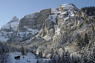
The Güpfi is a mountain of the Urner Alps, overlooking Lungern in the canton of Obwalden. It lies on the range north of the Chingstuel, between the Lungerersee and the Klein Melchtal.
The Chingstuel is a mountain of the Urner Alps, located on the border between the cantons of Obwalden and Bern. It lies between the Klein Melchtal and the region of Hasliberg.
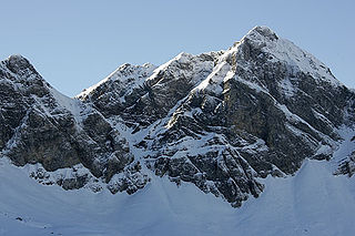
The Hochstollen is a mountain of the Urner Alps, located between the Klein Melchtal and the Melchtal in the canton of Obwalden. The border with the canton of Bern runs south of the summit.
The Haupt is a mountain of the Urner Alps, located between the Klein Melchtal and the Melchtal in the canton of Obwalden. Its east side consists of steep limestone cliffs overlooking Stöckalp and Melchsee-Frutt. On its west side it overlooks the Älggi-Alp.
The Heitlistock is a mountain of the Urner Alps, located between the Klein Melchtal and the Melchtal in the canton of Obwalden. It is situated west of Stöckalp.

The Widderfeld Stock is a mountain of the Urner Alps, located on the border between the Swiss cantons of Nidwalden and Obwalden. It is located between the valleys of Melchtal and Engelberg.
The Nünalphorn is a mountain of the Urner Alps, located on the border between the Swiss cantons of Nidwalden and Obwalden. It is located between the valleys of Melchtal and Engelberg.

The Duizendjarige den was a scots pine in the Wolfhezerbossen near Wolfheze, Netherlands. The tree fell down at 28 May 2006. It is estimated that the tree was nearly four hundred years old.

Kleine Huisjes is a village in the Dutch province of Groningen. It is a part of the municipality of Het Hogeland. It is located 1.5 kilometres (0.93 mi) north-east of Kloosterburen.

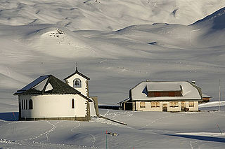
Melchtal is the denomination for the valley of the Grosse Melchaa in the canton Obwalden, Switzerland, and its namesake hamlet.
