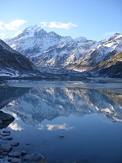
Aoraki / Mount Cook is the highest mountain in New Zealand. Its height, as of 2014, is listed as 3,724 metres. It sits in the Southern Alps, the mountain range that runs the length of the South Island. A popular tourist destination, it is also a favourite challenge for mountain climbers. Aoraki / Mount Cook consists of three summits: from south to north, the Low Peak, the Middle Peak and the High Peak. The summits lie slightly south and east of the main divide of the Southern Alps / Kā Tiritiri o te Moana, with the Tasman Glacier to the east and the Hooker Glacier to the southwest.

The Alpine region of Switzerland, conventionally referred to as the Swiss Alps, represents a major natural feature of the country and is, along with the Swiss Plateau and the Swiss portion of the Jura Mountains, one of its three main physiographic regions. The Swiss Alps extend over both the Western Alps and the Eastern Alps, encompassing an area sometimes called Central Alps. While the northern ranges from the Bernese Alps to the Appenzell Alps are entirely in Switzerland, the southern ranges from the Mont Blanc massif to the Bernina massif are shared with other countries such as France, Italy, Austria and Liechtenstein.

The Bernese Alps are a mountain range of the Alps, located in western Switzerland. Although the name suggests that they are located in the Berner Oberland region of the canton of Bern, portions of the Bernese Alps are in the adjacent cantons of Valais, Fribourg and Vaud, the latter being usually named Fribourg Alps and Vaud Alps respectively. The highest mountain in the range, the Finsteraarhorn, is also the highest point in the canton of Bern.

The Tödi, is a mountain massif and with the mountain peak Piz Russein the highest mountain in the Glarus Alps and the highest summit in the canton of Glarus, Switzerland. It is located on the border between the cantons of Graubünden, to the south, and Glarus, to the north, close to the point where those two cantons meet the canton of Uri, to the west. Although not the culminating point of Graubünden, it is its highest peak outside the Bernina range.

Mount Elbrus is the highest and most prominent peak in Russia and Europe. It is situated in the western part of the Caucasus and is the highest peak of the Caucasus Mountains. The dormant volcano rises 5,642 m (18,510 ft) above sea level; it is the highest stratovolcano in Eurasia, as well as the tenth-most prominent peak in the world. The mountain stands in Southern Russia, in the Russian republic of Kabardino-Balkaria.

The Matterhorn is a mountain of the Alps, straddling the main watershed and border between Switzerland and Italy. It is a large, near-symmetric pyramidal peak in the extended Monte Rosa area of the Pennine Alps, whose summit is 4,478 metres (14,692 ft) high, making it one of the highest summits in the Alps and Europe. The four steep faces, rising above the surrounding glaciers, face the four compass points and are split by the Hörnli, Furggen, Leone/Lion, and Zmutt ridges. The mountain overlooks the Swiss town of Zermatt, in the canton of Valais, to the north-east and the Italian town of Breuil-Cervinia in the Aosta Valley to the south. Just east of the Matterhorn is Theodul Pass, the main passage between the two valleys on its north and south sides, which has been a trade route since the Roman Era.

Monte Rosa is a mountain massif in the eastern part of the Pennine Alps. It is between Italy's and Switzerland's (Valais). Monte Rosa is the second highest mountain in the Alps and western Europe, after Mont Blanc.

The Grand Combin is a mountain massif in the western Pennine Alps in the canton of Valais. At a height of 4,314 metres (14,154 ft) the summit of Combin de Grafeneire is one of the highest peaks in the Alps and the second most prominent of the Pennine Alps. The Grand Combin is also a large glaciated massif consisting of several summits, among which three are above 4000 metres. The highest part of the massif is wholly in Switzerland, although the border with Italy lies a few kilometres south.

Furka Pass, with an elevation of 2,429 metres (7,969 ft), is a high mountain pass in the Swiss Alps connecting Gletsch, Valais with Realp, Uri. The Furka Oberalp Bahn line through the Furka Tunnel bypasses the pass. The base tunnel opened in 1982 and replaced a tunnel at 2100 metres.

Susten Pass is a mountain pass in the Swiss Alps. The pass road, built from 1938–1945, connects Innertkirchen in the canton of Bern with Wassen in the canton of Uri. A 300-metre long tunnel crosses the pass at 2,224 metres.

Titlis is a mountain of the Uri Alps, located on the border between the cantons of Obwalden and Bern. At 3,238 metres (10,623 ft) above sea level, it is the highest summit of the range north of the Susten Pass, between the Bernese Oberland and Central Switzerland. It is mainly accessed from Engelberg (OW) on the north side and is famous as the site of the world's first rotating cable car. The cable car system connects Engelberg to the summit of Klein Titlis through the three stages of Gerschnialp, Trübsee and Stand.

The Alphubel is a mountain of the Swiss Pennine Alps, located between the valleys of Zermatt and Saas in the canton of Valais. It is part of the Allalin Group, a subgroup of the Mischabel Group, which culminates at the Dom. The summit of the Alphubel consists of a large ice-covered plateau, part of the Fee Glacier on its east side. The west side of the mountain is more rocky and much steeper. It overlooks the Weingartensee.

The Dammastock is the highest mountain in the Urner Alps in Switzerland and is part of the Winterberg massif. Its summit ridge forms the border between the cantons of Uri and the Valais. It is the highest summit in the canton of Uri. The tripoint between the cantons of Berne, Valais and Uri lies near the Eggstock, north of the Dammastock. Politically, the Dammastcok is split between the municipalities of Göschenen (Uri) and Obergoms (Valais).
The Uri Alps are a mountain range in Central Switzerland and part of the Western Alps. They extend into the cantons of Obwalden, Valais, Bern, Uri and Nidwalden and are bordered by the Bernese Alps and the Emmental Alps to the west, the Schwyzer Alps to the north, the Lepontine Alps to the south and the Glarus Alps to the east (Reuss).
The Sustenhorn is a 3,502-metre-high (11,490 ft) mountain in the Uri Alps, located on the border between the cantons of Bern and Uri. It overlook Susten Pass from the south.
The Gwächtenhorn is a 3,420 metres high mountain in the Urner Alps, located on the border between the cantons of Bern and Uri. It overlooks the Stein Glacier and the Susten Pass on its north side (Bern) and the Chelen Glacier on its south side (Uri).

The Fleckistock is a 3,417 metres high mountain in the Urner Alps, overlooking Wassen in the canton of Uri. It is the highest summit of the group lying east of the pass of Sustenjoch. This range, starting at the Stucklistock and ending at the Salbitschijen, separates the valleys of Voralp, above Göschenen and Meiental, above Wassen.

Piz Nair is a mountain of the Glarus Alps, located on the border between the Swiss cantons of Uri and Graubünden. Together with Piz Giuv on the west, it overlooks the end of the Etzli valley in the canton of Uri. The south-west and the south-east sides overlook respectively the small valleys of Val Giuv and Val Milà, both converging to the Rhine valley west of Sedrun (Graubünden). The mountain is politically divided between the municipalities of Silenen (Uri) and Tujetsch (Graubünden).

The Düssi is a mountain in the Glarus Alps in central Switzerland, located on the border between the cantons of Uri and Graubünden. Its massif separates the valleys of Maderanertal (Uri) and Val Russein (Graubünden). The summit is also named Gross Düssi to distinguish it from a lower summit to the south named Chli Düssi.
The Heimstock is a mountain of the Glarus Alps, located on the border between the Swiss cantons of Uri and Graubünden. It lies between the Maderanertal (Uri) and the Val Russein (Graubünden). On its northern side lies the Hüfi Glacier.

