A Uniform Resource Identifier (URI) is a unique sequence of characters that identifies a logical or physical resource used by web technologies. URIs may be used to identify anything, including real-world objects, such as people and places, concepts, or information resources such as web pages and books. Some URIs provide a means of locating and retrieving information resources on a network ; these are Uniform Resource Locators (URLs). A URL provides the location of the resource. A URI identifies the resource by name at the specified location or URL. Other URIs provide only a unique name, without a means of locating or retrieving the resource or information about it, these are Uniform Resource Names (URNs). The web technologies that use URIs are not limited to web browsers. URIs are used to identify anything described using the Resource Description Framework (RDF), for example, concepts that are part of an ontology defined using the Web Ontology Language (OWL), and people who are described using the Friend of a Friend vocabulary would each have an individual URI.

Titlis is a mountain of the Uri Alps, located on the border between the cantons of Obwalden and Bern. At 3,238 metres (10,623 ft) above sea level, it is the highest summit of the range north of the Susten Pass, between the Bernese Oberland and Central Switzerland. It is mainly accessed from Engelberg (OW) on the north side and is famous as the site of the world's first rotating cable car. The cable car system connects Engelberg to the summit of Klein Titlis through the three stages of Gerschnialp, Trübsee and Stand.
The Congressional Hispanic Leadership Institute (CHLI) is a 501(c)3 non-profit and non-partisan organization founded by Members of Congress to advance the Hispanic Community's Economic Progress with a focus on Social Responsibility and Global Competitiveness.

The Uri Alps are a mountain range in Central Switzerland and part of the Western Alps. They extend into the cantons of Obwalden, Valais, Bern, Uri and Nidwalden and are bordered by the Bernese Alps and the Emmental Alps to the west, the Schwyzer Alps to the north, the Lepontine Alps to the south and the Glarus Alps to the east (Reuss).

The Gross Windgällen is a 3,187 m high mountain in the Glarus Alps, overlooking the valley of the Reuss in the canton of Uri. The name Gross Windgällen derives from Gälle or gellen, meaning as much as wailing, shrilling or whistling.
CHLI-FM, or Rossland Community Radio Co-operative, was a volunteer-led co-operative community radio station in Rossland, British Columbia, Canada.
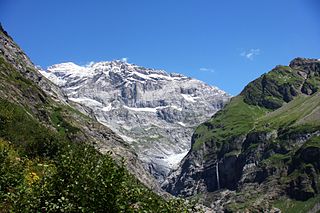
The Sustenhorn is a 3,502-metre-high (11,490 ft) mountain in the Uri Alps, located on the border between the cantons of Bern and Uri. It overlook Susten Pass from the south.

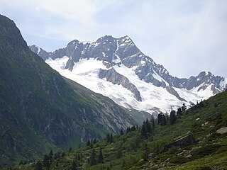
The Gross Spannort is a mountain of the Uri Alps, located between Engelberg and Erstfeld in Central Switzerland. It is located within the canton of Uri, although its summit lies on the watershed between the Engelberger Aa and the main Reuss valley. The Gross Spannort is almost entirely surrounded by glaciers, the largest being the Glatt Firn. South-west of the Gross Spannort is the Chli Spannort.
The Schärhorn is a mountain in the Glarus Alps near Klausen Pass. The highest summit is named Gross Schärhorn while a second summit is named Chli Schärhorn. The mountain overlooks the valley of Schächental to the north side, and the Hüfifirn to the southeast, which finally leads to the Maderanertal to the southwest. Both valleys are located in the canton of Uri.

The Gross Ruchen is a mountain in the Glarus Alps, overlooking the Brunnital south of Unterschächen in the canton of Uri. It is located between the higher Gross Windgallen on the west and the Chli Ruchen on the east.

The Leckihorn is a mountain in the Lepontine Alps, located on the border between the cantons of Valais and Uri. Its summit is also named Gross Leckihorn to distinguish it from a lower summit named Chli Leckihorn.

The Düssi is a mountain in the Glarus Alps in central Switzerland, located on the border between the cantons of Uri and Graubünden. Its massif separates the valleys of Maderanertal (Uri) and Val Russein (Graubünden). The summit is also named Gross Düssi to distinguish it from a lower summit to the south named Chli Düssi.
The Grassengrat is a multi-summited mountain of the Urner Alps, located on the border between the cantons of Obwalden and Uri in Central Switzerland. It lies on the range between the Titlis and the Gross Spannort. The main summit has an elevation of 2,941 metres and is named Stössenstock.

The Chli Windgällen is a mountain of the Glarus Alps, overlooking the valley of the Reuss in the canton of Uri. It lies west of the Gross Windgällen, on the range north of the Maderanertal.

The Muttenhorn is a mountain in the Lepontine Alps, located on the border between the cantons of Valais and Uri. At 3,099 metres above sea level, it overlooks the south side of Furka Pass. A glacier named Muttgletscher lies over its north-western flanks, above 2,600 metres.

The Schlossberg is a mountain of the Urner Alps, located between Engelberg and Erstfeld in Central Switzerland. It lies north of the Gross Spannort in the canton of Uri.

The Chli Ruchen is a mountain of the Glarus Alps, overlooking the Brunnital south of Unterschächen in the canton of Uri. It is located between the higher Gross Ruchen on the west and the Schärhorn on the east.
A Uniform Resource Locator (URL), colloquially termed a web address, is a reference to a web resource that specifies its location on a computer network and a mechanism for retrieving it. A URL is a specific type of Uniform Resource Identifier (URI), although many people use the two terms interchangeably. URLs occur most commonly to reference web pages (http) but are also used for file transfer (ftp), email (mailto), database access (JDBC), and many other applications.
Fulen may refer to mountains:

Margarita Chli is an assistant professor and leader of the Vision for Robotics Lab at ETH Zürich in Switzerland. Chli is a leader in the field of computer vision and robotics and was on the team of researchers to develop the first fully autonomous helicopter with onboard localization and mapping. Chli is also the Vice Director of the Institute of Robotics and Intelligent Systems and an Honorary Fellow of the University of Edinburgh in the United Kingdom. Her research currently focuses on developing visual perception and intelligence in flying autonomous robotic systems.

