
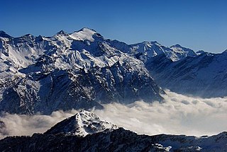
The Bernese Alps are a mountain range of the Alps, located in western Switzerland. Although the name suggests that they are located in the Berner Oberland region of the canton of Bern, portions of the Bernese Alps are in the adjacent cantons of Valais, Fribourg and Vaud, the latter being usually named Fribourg Alps and Vaud Alps respectively. The highest mountain in the range, the Finsteraarhorn, is also the highest point in the canton of Bern.

The Tödi, is a mountain massif and with the mountain peak Piz Russein the highest mountain in the Glarus Alps and the highest summit in the canton of Glarus, Switzerland. It is located on the border between the cantons of Graubünden, to the south, and Glarus, to the north, close to the point where those two cantons meet the canton of Uri, to the west. Although not the culminating point of Graubünden, it is its highest peak outside the Bernina range.

Aneto is the highest mountain in the Pyrenees and in Aragon, and Spain's third-highest mountain, reaching a height of 3,404 metres. It stands in the Spanish province of Huesca, the northernmost of the three Aragonese provinces, 6 kilometres south of the France–Spain border. It forms the southernmost part of the Maladeta massif.

The Diablerets are a huge ice-covered mountain massif of the Alps, culminating at the Sommet des Diablerets at 3,210 metres (10,530 ft) above sea level and straddling the border between the Swiss cantons of Vaud (VD) and Valais (VS). The northeastern part of the massif stretches also into the canton of Bern (BE).

The Dent Blanche is a mountain in the Pennine Alps, lying in the canton of Valais in Switzerland. At 4,358 metres (14,298 ft)-high, it is one of the highest peaks in the Alps.

Monte Rosa is a mountain massif in the eastern part of the Pennine Alps. It is between Italy's and Switzerland's (Valais). Monte Rosa is the second highest mountain in the Alps and western Europe, after Mont Blanc.

The Dom is a mountain of the Pennine Alps, located between Randa and Saas-Fee in the canton of Valais in Switzerland. With a height of 4,545 m (14,911 ft), it is the seventh highest summit in the Alps, overall. Based on prominence, it can be regarded as the third highest mountain in the Alps, and the second highest in Switzerland, after Monte Rosa. The Dom is the main summit of the Mischabel group, which is the highest massif lying entirely in Switzerland.

The Grand Combin is a mountain massif in the western Pennine Alps in the canton of Valais. At a height of 4,314 metres (14,154 ft) the summit of Combin de Grafeneire is one of the highest peaks in the Alps and the second most prominent of the Pennine Alps. The Grand Combin is also a large glaciated massif consisting of several summits, among which three are above 4000 metres. The highest part of the massif is wholly in Switzerland, although the border with Italy lies a few kilometres south.

Susten Pass is a mountain pass in the Swiss Alps. The pass road, built from 1938–1945, connects Innertkirchen in the canton of Bern with Wassen in the canton of Uri. A 300-metre long tunnel crosses the pass at 2,224 metres.
The Rheinwaldhorn is the highest point in the Swiss canton of Ticino at 3,402 metres above sea level. It lies on the border between the cantons of Graubünden and Ticino, in the Adula massif, part of the St. Gotthard massif of the Lepontine Alps in southern Switzerland.

The Ober Gabelhorn is a mountain in the Pennine Alps in Switzerland, located between Zermatt and Zinal.

The Alphubel is a mountain of the Swiss Pennine Alps, located between the valleys of Zermatt and Saas in the canton of Valais. It is part of the Allalin Group, a subgroup of the Mischabel Group, which culminates at the Dom. The summit of the Alphubel consists of a large ice-covered plateau, part of the Fee Glacier on its east side. The west side of the mountain is more rocky and much steeper. It overlooks the Weingartensee.

The Weisshorn is a major peak of Switzerland and the Alps, culminating at 4,506 metres above sea level. It is part of the Pennine Alps and is located between the valleys of Anniviers and Zermatt in the canton of Valais. In the latter valley, the Weisshorn is one of the many 4000ers surrounding Zermatt, with Monte Rosa and the Matterhorn.

The Wildhorn is a mountain of the Alps, straddling the border between the Swiss cantons of Bern and Valais. At 3,248 metres (10,656 ft) above sea level, it is the highest summit of the Bernese Alps west of the Gemmi Pass. It forms a large glaciated massif, about 10 km wide, extending between the Sanetsch Pass and the Rawil Pass. Along with the Muverans, the Diablerets and the Wildstrubel, the Wildhorn is one of the four distinct mountain massifs of the Bernese Alps that lie west of the Gemmi Pass. The massif of the Wildhorn is at the centre between the valleys of the Saane, Simme and the Rhone (Valais). It comprises several distinct summits, including the Arpelistock, Le Sérac, the Geltenhorn, the Sex Noir, the Sex Rouge, the Schnidehorn and the Six des Eaux Froides. The main crest is between the glaciers named Tungelgletscher and Glacier du Wildhorn. South of the main summit is the almost equally high summit of Mont Pucel. The Wildhorn is surrounded by several large mountain lakes: the Lac de Sénin, the Lauenensee, the Iffigsee, the Lac de Tseuzier and the Lac des Audannes. The Tungelgletscher, on the north-east face, was measured as 1.9 km in length in 1973.

The Gross Windgällen is a 3,187 m high mountain in the Glarus Alps, overlooking the valley of the Reuss in the canton of Uri. The name Gross Windgällen derives from Gälle or gellen, meaning as much as wailing, shrilling or whistling.

The Eggishorn is a mountain in the southeastern part of the Bernese Alps, located north of Fiesch in the Swiss canton of Valais. A cable car station is located on a secondary summit named Fiescherhorli, 500 metres south of the main peak.

Pizzo Rotondo is a mountain in the Lepontine Alps. At 3,190 metres above sea level, it is the highest mountain lying on the border between the cantons of Ticino and Valais, as well as the highest summit of the Lepontine Alps lying between Nufenen Pass and Lukmanier Pass.

The Portjengrat is a mountain of the Pennine Alps, located on the border between Switzerland and Italy. It lies south of the Weissmies and the Zwischbergen Pass, where the international border diverges away from the main Alpine watershed. The summit of the Portjengrat has an elevation of 3,654 metres above sea level and is the tripoint between the valleys of Saas, Divedro and Antrona. It is the culminating point of the Antrona valley.
The Rorspitzli is a mountain of the Urner Alps, located west of Wassen and Göschenen in the canton of Uri. It lies on the range east of the Sustenjoch, culminating at the Fleckistock.
The Strahlkogel, at 3,288 m (AA), is the highest peak in the Larstiger Mountains, a subgroup of the Stubai Alps in the Austrian state of Tyrol. The Strahlkogel is also the highest mountain in the municipality of Umhausen. Its name comes from its great, white, light-reflecting, quartz layers, which allegedly cause the mountain to "radiate" (strahlen). It has the shape of a well-proportioned, steep and pointed pyramid. Ascending the Strahlkogel is difficult and it is thus only rarely visited, unlike the neighbouring 3,287-metre-high Breiter Grieskogel. The first ascent of the mountain was in 1833 by Peter Carl Thurwieser, but his route and the precise circumstances of the climb have not been passed on. On 28 August 1887 Ludwig Purtscheller and Fritz Drasch from Salzburg climbed the mountain. Their route led along the west arête. Today, this is the normal route and easiest way to reach the summit.

