Wassen

Last updated
Wassen
Kirche Wassen.jpg
Wappen Wassen.svg
Location of Wassen
Wassen
Switzerland adm location map.svg
Red pog.svg
Wassen
Reliefkarte Uri blank.png
Red pog.svg
Wassen
Coordinates: 46°42′N8°35′E / 46.700°N 8.583°E / 46.700; 8.583
Country Switzerland
Canton Uri
District n.a.
Area
[1]
  Total96.88 km2 (37.41 sq mi)
Elevation
930 m (3,050 ft)
Population
 (31 December 2018) [2]
  Total398
  Density4.1/km2 (11/sq mi)
Time zone UTC+01:00 (Central European Time)
  Summer (DST) UTC+02:00 (Central European Summer Time)
Postal code(s)
6484
SFOS number 1220
Surrounded by Attinghausen, Engelberg (OW), Erstfeld, Gadmen (BE), Göschenen, Gurtnellen
Website www.wassen.ch
SFSO statistics

Wassen is a municipality in the canton of Uri in Switzerland.

Contents

Geography

Double loop curved tunnel on the Gotthardbahn rail line near Wassen PfaffensprungSpiralTunnel DoubleLoopCurvedAlignmentTunnels atWassen onNorthernRampToGotthardTunnel.jpg
Double loop curved tunnel on the Gotthardbahn rail line near Wassen
Aerial view (1963) ETH-BIB-Wassen-LBS H1-023873.tif
Aerial view (1963)

As of 2006, Wassen has an area of 97 km2 (37 sq mi). Of this area, 12.5% is used for agricultural purposes, while 18.2% is forested. Of the rest of the land, 1.1% is settled (buildings or roads) and the remainder (68.1%) is non-productive (rivers, glaciers or mountains). [3] In the 1993/97 land survey, 9.6% of the total land area was heavily forested, while 6.8% is covered in small trees and shrubbery. Of the agricultural land, 2.5% is used for orchards or vine crops and 10.1% is used for alpine pastures. Of the settled areas, 0.2% is covered with buildings, and 0.8% is transportation infrastructure. Of the unproductive areas, 0.1% is unproductive standing water (ponds or lakes), 1.2% is unproductive flowing water (rivers), 48.5% is too rocky for vegetation, and 18.3% is other unproductive land. [4]

It is on the Gotthard line and the rail line makes a double loop near Wassen to help the trains deal with the climb. The Susten Pass connects Wassen with Innertkirchen.

Sights

The Gottardo-Weitwanderweg (long-distance hiking trail) between Erstfeld and Biasca was opened for the 125th anniversary of the Gotthard Railway. Panels at over 50 places, including Wassen, provide information on the Gotthard Region and its railway. Waterworld educational and experience trail is a 60 km (37 mi) long network of trails in nearby Göscheneralptal with 90 stations devoted to the theme of water. The Schöllenen Gorge is a gorge, over which, according to legend, a bridge could only be built with the help of the devil. The Pfaffensprung crystal caves is a 165 m (541 ft) long crystal cave. It is the second largest crystal cave in Switzerland and has provided large quantities of mountain crystals for centuries. Accessible with a guide. [5]

Demographics

Wassen in 1845 Wassen Gotthardpost 1845.jpg
Wassen in 1845

Wassen has a population (as of 31 December 2020) of 412. [6] As of 2007, 7.2% of the population was made up of foreign nationals. Over the last 10 years the population has decreased at a rate of -16%. Most of the population (as of 2000) speaks German (94.2%), with Serbo-Croatian being second most common (2.4%) and Italian being third (1.3%). [3] As of 2007 the gender distribution of the population was 51.8% male and 48.2% female. [7]

In the 2007 federal election the FDP party received 85.9% of the vote. [3]

In Wassen about 53% of the population (between age 25–64) have completed either non-mandatory upper secondary education or additional higher education (either university or a Fachhochschule ). [3]

Wassen has an unemployment rate of 0.64%. As of 2005, there were 43 people employed in the primary economic sector and about 18 businesses involved in this sector. 34 people are employed in the secondary sector and there are 7 businesses in this sector. 121 people are employed in the tertiary sector, with 18 businesses in this sector. [3]

The historical population is given in the following table: [8]

yearpopulation
1970764
1980671
1990545
2000465
2005466
2007456

Related Research Articles

<span class="mw-page-title-main">Canton of Uri</span> Canton of Switzerland

The canton of Uri is one of the 26 cantons of Switzerland and a founding member of the Swiss Confederation. It is located in Central Switzerland. The canton's territory covers the valley of the Reuss between the St. Gotthard Pass and Lake Lucerne.
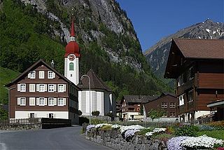
<span class="mw-page-title-main">Göschenen</span> Municipality in Uri, Switzerland

Göschenenlocally[ɡɔʊʃɛnɛn] is a village and municipality in the canton of Uri in Switzerland. It sits at the northern end of the Gotthard tunnel. The Göschenen riots (1875) saw Urner troops opening fire on Italian miners demonstrating for better working conditions and wages on the tunnel's construction site.

<span class="mw-page-title-main">Andermatt</span> Municipality in Uri, Switzerland

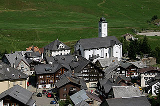
Andermatt is a mountain village and municipality in the canton of Uri in Switzerland. At an elevation of 1,437 meters (4,715 ft) above sea level, Andermatt is located at the center of the Saint-Gotthard Massif and the historical center cross of north-south and east-west traverses of Switzerland. It is some 28 km (17 mi) south of Altdorf, the capital of Uri.

<span class="mw-page-title-main">Isenthal</span> Municipality in Uri, Switzerland

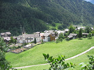
Isenthal is a municipality in the canton of Uri in Switzerland.

<span class="mw-page-title-main">Sisikon</span> Municipality in Uri, Switzerland

Sisikon is a municipality in the canton of Uri in Switzerland. It is situated on the shore of Lake Lucerne.

<span class="mw-page-title-main">Attinghausen</span> Municipality in Uri, Switzerland

Attinghausen is a village and a municipality in the canton of Uri in Switzerland.

<span class="mw-page-title-main">Bürglen, Uri</span> Municipality in Uri, Switzerland

Bürglen is a municipality in the canton of Uri in Switzerland.

<span class="mw-page-title-main">Erstfeld</span> Municipality in Uri, Switzerland

Erstfeld is a municipality in the canton of Uri in Switzerland.

<span class="mw-page-title-main">Flüelen</span> Municipality in Uri, Switzerland

Flüelen is a municipality in the canton of Uri in Switzerland.

<span class="mw-page-title-main">Gurtnellen</span> Municipality in Uri, Switzerland

Gurtnellen is a village and a municipality in the canton of Uri in Switzerland.

<span class="mw-page-title-main">Hospental</span> Municipality in Uri, Switzerland

Hospental is a municipality in the canton of Uri in Switzerland.

<span class="mw-page-title-main">Realp</span> Municipality in Uri, Switzerland

Realp is a municipality in the canton of Uri in Switzerland.

<span class="mw-page-title-main">Schattdorf</span> Municipality in Uri, Switzerland

Schattdorf is a village and a municipality in the canton of Uri in Switzerland.

<span class="mw-page-title-main">Seelisberg</span> Municipality in Uri, Switzerland

Seelisberg is a municipality in the canton of Uri in Switzerland.

<span class="mw-page-title-main">Silenen</span> Municipality in Uri, Switzerland

Silenen is a municipality in the canton of Uri in Switzerland.

<span class="mw-page-title-main">Spiringen</span> Municipality in Uri, Switzerland

Spiringen is a village and a municipality in the canton of Uri in Switzerland. The municipality comprises two disjoint areas, separated by the municipality of Unterschächen and the Klausen Pass. The western area includes the village of Spiringen in the Schächen Valley, whilst the eastern area includes the Urner Boden alp above Linthal and the canton of Glarus.

<span class="mw-page-title-main">Unterschächen</span> Municipality in Uri, Switzerland

Unterschächen is a municipality in the canton of Uri in Switzerland, situated in the upper Schächental.

<span class="mw-page-title-main">Schötz</span> Municipality in Lucerne, Switzerland

Schötz is a municipality in the district of Willisau in the canton of Lucerne in Switzerland. On 1 January 2013 the former municipality of Ohmstal merged into the municipality of Schötz.

<span class="mw-page-title-main">Kippel</span> Municipality in Valais, Switzerland

Kippel is a municipality in the district of Raron in the canton of Valais in Switzerland.

<span class="mw-page-title-main">Mörel-Filet</span> Municipality in Valais, Switzerland

Mörel-Filet is a municipality in the district of Östlich Raron in the canton of Valais, Switzerland. It was formed on 1. January 2009 when Mörel and Filet were merged.

References

  1. "Arealstatistik Standard - Gemeinden nach 4 Hauptbereichen". Federal Statistical Office. Retrieved 13 January 2019.
  2. "Ständige Wohnbevölkerung nach Staatsangehörigkeitskategorie Geschlecht und Gemeinde; Provisorische Jahresergebnisse; 2018". Federal Statistical Office. 9 April 2019. Retrieved 11 April 2019.
  3. 1 2 3 4 5 Swiss Federal Statistical Office accessed 09-Sep-2009
  4. Canton Uri - Ground use statistics (in German) accessed 8 September 2009
  5. "Kristallhöhle Pfaffensprung (Pfaffensprung Crystal Cave)". andermatt.ch. Retrieved 10 May 2021.
  6. "Ständige und nichtständige Wohnbevölkerung nach institutionellen Gliederungen, Geburtsort und Staatsangehörigkeit". bfs.admin.ch (in German). Swiss Federal Statistical Office - STAT-TAB. 31 December 2020. Retrieved 21 September 2021.
  7. Uri Population statistics (in German) accessed 8 September 2009
  8. Uri in Numbers 2009/10 edition (in German) accessed 8 September 2009