Isenthal is first mentioned in 1280 as Yseltal.[3]
Geography
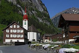
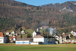
Isenthal Church and villageCemetery and bank in Isenthal
Isenthal has an area, (as of the 2004/09 survey) of 60.97km2 (23.54sqmi).[4] Of this area, about 28.0% is used for agricultural purposes, while 27.1% is forested. Of the rest of the land, 0.8% is settled (buildings or roads) and 44.0% is unproductive land. Over the past two decades (1979/85-2004/09) the amount of land that is settled has increased by 17ha (42 acres) and the agricultural land has decreased by 32ha (79 acres).[5]
In the 1993 land survey[update], 21.4% of the total land area was heavily forested, while 1.4% is covered in small trees and shrubbery. Of the agricultural land, 5.7% is used for orchards or vine crops and 22.2% is used for alpine pastures. Of the settled areas, 0.3% is covered with buildings, and 0.2% is transportation infrastructure. Of the unproductive areas, 0.9% is unproductive flowing water (rivers), 35.6% is too rocky for vegetation, and 8.8% is other unproductive land.[6]
The municipality is located at the intersection of the Chlital and the Grosstal. It consists of the village of Isenthal and widely scattered small settlements.
Demographics
Isenthal has a population (as of December 2020[update]) of 476.[7]As of 2013[update], 1.0% of the population are resident foreign nationals. Over the last 3 years (2010-2013) the population has changed at a rate of -0.95%. The birth rate in the municipality, in 2013, was 3.8 while the death rate was 5.7 per thousand residents.[5]
As of 2013[update], children and teenagers (0–19 years old) make up 25.6% of the population, while adults (20–64 years old) are 58.4% and seniors (over 64 years old) make up 16.0%.[5]
In 2013 there were 168 private households in Isenthal. Of the 172 inhabited buildings in the municipality, in 2000, about 47.7% were single family homes and 16.9% were multiple family buildings. Additionally, about 44.8% of the buildings were built before 1919, while 14.0% were built between 1991 and 2000.[8] In 2012 the rate of construction of new housing units per 1000 residents was 1.89. The vacancy rate for the municipality, in 2014[update], was 1.61%.[5]
Most of the population (as of 2000[update]) speaks German (99.3%), with Polish being second most common (0.4%) and French being third (0.2%).[9]As of 2007[update] the gender distribution of the population was 52.4% male and 47.6% female.[10]
The historical population is given in the following table:[3][11]
Year
Population
1698
c. 150
1743
176
1799
360
1850
502
1900
595
1950
550
1970
570
1980
535
1990
505
2000
539
2005
538
2007
536
Economy
As of 2012[update], there were a total of 215 people employed in the municipality. Of these, a total of 129 people worked in 47 businesses in the primary economic sector. The secondary sector employed 26 workers in 13 separate businesses. Finally, the tertiary sector provided 60 jobs in 18 businesses. In 2013 a total of 1.9% of the population received social assistance.[5]
Politics
In the 2015 federal election the most popular party was the CVP with 53.5% of the vote. The next three most popular parties were the SVP (28.0%), the GPS (17.0%) and other candidates received 1.5%. In the federal election, a total of 204 votes were cast, and the voter turnout was 51.5%. The 2015 election saw a large change in the voting when compared to 2011, due to only certain parties running candidates in each election. In 2011 only the SP and the FDP.The Liberals had candidates on the ballot, while in 2015 only the CVP, SVP and GPS ran.[12]
In Isenthal about 60.5% of the population (between age 25–64) have completed either non-mandatory upper secondary education or additional higher education (either university or a Fachhochschule).[9]
Weather
Isenthal has an average of 150.2 days of rain per year and on average receives 1,562mm (61.5in) of precipitation. The wettest month is July during which time Isenthal receives an average of 193mm (7.6in) of precipitation. During this month there is precipitation for an average of 14.4 days. The month with the most days of precipitation is June, with an average of 15.5, but with only 182mm (7.2in) of precipitation. The driest month of the year is February with an average of 95mm (3.7in) of precipitation over 14.4 days.[13]
Related Research Articles
Göschenenlocally[ɡɔʊʃɛnɛn] is a village and municipality in the canton of Uri in Switzerland. It sits at the northern end of the Gotthard tunnel. The Göschenen riots (1875) saw Urner troops opening fire on Italian miners demonstrating for better working conditions and wages on the tunnel's construction site.
Beromünster is a municipality in the district of Sursee in the canton of Lucerne in Switzerland. On 1 January 2004 the former municipality of Schwarzenbach merged into the municipality of Beromünster. On 1 January 2009 the former municipality of Gunzwil merged into the municipality of Beromünster followed by Neudorf on 1 January 2013.
Sempach is a municipality in the district of Sursee in the canton of Lucerne in Switzerland.
Baulmes is a municipality in the district of Jura-Nord Vaudois in the canton of Vaud in Switzerland.
Attinghausen is a village and a municipality in the canton of Uri in Switzerland.
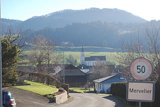
Mervelier is a municipality in the district of Delémont in the canton of Jura in Switzerland.
Bürglen is a municipality in the canton of Uri in Switzerland.
Jaun is a municipality in the district of Gruyère in the canton of Fribourg in Switzerland. It is the only German-speaking municipality in Gruyère.
Erstfeld is a municipality in the canton of Uri in Switzerland.
Flüelen is a municipality in the canton of Uri in Switzerland.
Gurtnellen is a village and a municipality in the canton of Uri in Switzerland.
Unterschächen is a municipality in the canton of Uri in Switzerland, situated in the upper Schächental.
Escholzmatt is a former municipality in the district of Entlebuch in the canton of Lucerne in Switzerland. Escholzmatt was the Canton's second largest municipality in terms of area. It is part of the UNESCO Entlebuch Biosphere Reserve since 2001. On 1 January 2013 the former municipalities of Escholzmatt and Marbach merged to form the new municipality of Escholzmatt-Marbach.
Luthern is a municipality in the district of Willisau in the canton of Lucerne in Switzerland.
Affeltrangen is a municipality in the district of Münchwilen in the canton of Thurgau in Switzerland.
Braunau is a municipality in the district of Münchwilen in the canton of Thurgau in Switzerland.
Thundorf is a municipality in the district of Frauenfeld in the canton of Thurgau in Switzerland.
Balsthal is a municipality in the district of Thal in the canton of Solothurn in Switzerland.
Herbetswil is a municipality in the district of Thal in the canton of Solothurn in Switzerland.
Sonogno is a village and former municipality in the district of Locarno in the canton of Ticino in Switzerland. It is located in Valle Verzasca. On 17 October 2020 the former municipalities of Vogorno, Sonogno, Corippo, Brione (Verzasca) and Frasco merged to form the new municipality of Verzasca.
This page is based on this Wikipedia article Text is available under the CC BY-SA 4.0 license; additional terms may apply. Images, videos and audio are available under their respective licenses.