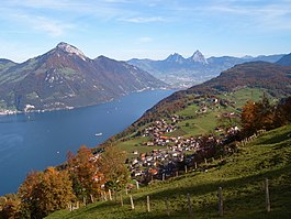
Emmetten

Last updated
Emmetten
Emmetten.jpg
CHE Emmetten Flag.svg
CHE Emmetten COA.svg
Location of Emmetten
Emmetten
Switzerland adm location map.svg
Red pog.svg
Emmetten
Reliefkarte Nidwalden blank.png
Red pog.svg
Emmetten
Coordinates: 46°57′N8°31′E / 46.950°N 8.517°E / 46.950; 8.517
Country Switzerland
Canton Nidwalden
District n.a.
Area
[1]
  Total
28.63 km2 (11.05 sq mi)
Elevation
774 m (2,539 ft)
Population
 (31 December 2018) [2]
  Total
1,429
  Density50/km2 (130/sq mi)
Time zone UTC+01:00 (Central European Time)
  Summer (DST) UTC+02:00 (Central European Summer Time)
Postal code(s)
6376
SFOS number 1504
ISO 3166 code CH-NW
Surrounded by Beckenried, Gersau (SZ), Ingenbohl (SZ), Isenthal (UR), Seelisberg (UR)
Website www.emmetten.ch
SFSO statistics

Emmetten is a municipality in the canton of Nidwalden in Switzerland.

Contents

History

Emmetten is first mentioned about 1160 as Empnoten. [3]

Geography

Aerial view (1956) ETH-BIB-Emmetten, Ober-Niederbauen-LBS H1-019403.tif
Aerial view (1956)

Emmetten has an area, as of 2006, of 25 square kilometers (9.7 sq mi). Of this area, 37.9% is used for agricultural purposes, while 45.8% is forested. Of the rest of the land, 2.6% is settled (buildings or roads) and the remainder (13.7%) is non-productive (rivers, glaciers or mountains). [4]

The municipality is located along the cantonal highway between Beckenried and Seelisberg on both sides of the Egg crossing over the edge of Lake Lucerne.

Demographics

Emmetten has a population (as of 31 December 2020) of 1,541. [5] As of 2007, 15.4% of the population was made up of foreign nationals. [6] Over the last 10 years the population has grown at a rate of 3.7%. Most of the population (as of 2000) speaks German (91.8%), with English being second most common ( 1.8%) and Italian being third ( 1.5%). [4] As of 2008 the gender distribution of the population was 53.4% male and 46.6% female.

As of 2000 there are 487 households, of which 310 households (or about 63.7%) contain only one or two individuals. 36 or about 7.4% are large households, with at least five members. [7]

In the 2007 federal election the most popular party was the FDP which received 87.1% of the vote. Most of the rest of the votes went to local small right-wing parties (9.9%). [4]

In Emmetten about 69.1% of the population (between age 25-64) have completed either non-mandatory upper secondary education or additional higher education (either university or a Fachhochschule ). [4]

The historical population is given in the following table: [3]

yearpopulation
1743378
1850659
1860603
1880632
1900593
1950680
1960698
1970631
1980715
19901,013
20001,222
20051,184

Industry

Emmetten has an unemployment rate of 0.94%. As of 2005, there were 75 people employed in the primary economic sector and about 27 businesses involved in this sector. 38 people are employed in the secondary sector and there are 9 businesses in this sector. 198 people are employed in the tertiary sector, with 42 businesses in this sector. [4]

Sights

The main sights of Emmetten are: the St. Anna chapel in Schöneck, the church St. Jakob und St. Theresia, the chapel of the holy cross with frescos of danse macabre in Sagendorf, and the chapel in Erlen.

References

  1. "Arealstatistik Standard - Gemeinden nach 4 Hauptbereichen". Federal Statistical Office. Retrieved 13 January 2019.
  2. "Ständige Wohnbevölkerung nach Staatsangehörigkeitskategorie Geschlecht und Gemeinde; Provisorische Jahresergebnisse; 2018". Federal Statistical Office. 9 April 2019. Retrieved 11 April 2019.
  3. 1 2 Emmetten in German , French and Italian in the online Historical Dictionary of Switzerland .
  4. 1 2 3 4 5 Swiss Federal Statistical Office Archived January 5, 2016, at the Wayback Machine accessed 04-Sep-2009
  5. "Ständige und nichtständige Wohnbevölkerung nach institutionellen Gliederungen, Geburtsort und Staatsangehörigkeit". bfs.admin.ch (in German). Swiss Federal Statistical Office - STAT-TAB. 31 December 2020. Retrieved 21 September 2021.
  6. Nidwalden Statistical Office-Population (in German) accessed 4 September 2009
  7. Nidwalden Statistical Office-Municipalities [ permanent dead link ](in German) accessed 4 September 2009