Hergiswil

Last updated
Hergiswil
Hergiswil.jpg
CHE Hergiswil COA.svg
Location of Hergiswil
Hergiswil
Switzerland adm location map.svg
Red pog.svg
Hergiswil
Reliefkarte Nidwalden blank.png
Red pog.svg
Hergiswil
Coordinates: 46°58′N8°18′E / 46.967°N 8.300°E / 46.967; 8.300
Country Switzerland
Canton Nidwalden
District n.a.
Area
[1]
  Total17.00 km2 (6.56 sq mi)
Elevation
449 m (1,473 ft)
Population
 (31 December 2018) [2]
  Total5,777
  Density340/km2 (880/sq mi)
Time zone UTC+01:00 (Central European Time)
  Summer (DST) UTC+02:00 (Central European Summer Time)
Postal code(s)
6052
SFOS number 1507
Surrounded by Alpnach (OW), Horw (LU), Kriens (LU), Schwarzenberg (LU), Stansstad
Website www.hergiswil.ch
SFSO statistics

Hergiswil is a municipality in the canton of Nidwalden in Switzerland.

Contents

History

Hergiswil is first mentioned around 1303-09 as ze Hergenswile. [3]

Geography

Aerial view (1964) ETH-BIB-Hergiswil-LBS H1-024425.tif
Aerial view (1964)

Hergiswil has an area, as of 2006, of 14.2 square kilometers (5.5 sq mi). Of this area, 29.3% is used for agricultural purposes, while 44.4% is forested. Of the rest of the land, 9.7% is settled (buildings or roads) and the remainder (16.6%) is non-productive (rivers, glaciers or mountains). [4]

The municipality is located between the foot of Mount Pilatus and Lake Lucerne.

Demographics

Hergiswil has a population (as of 31 December 2020) of 5,863. [5] As of 2007, 14.5% of the population was made up of foreign nationals. [6] Over the last 10 years the population has grown at a rate of 11.5%. Most of the population (as of 2000) speaks German (91.0%), with Italian being second most common ( 2.0%) and French being third ( 1.1%). [4] As of 2008 the gender distribution of the population was 52.2% male and 47.8% female.

As of 2000 there are 2,216 households, of which 1,627 households (or about 73.4%) contain only one or two individuals. 91 or about 4.1% are large households, with at least five members. [7]

In the 2007 federal election the most popular party was the FDP which received 89.1% of the vote. Most of the rest of the votes went to local small right-wing parties (9.3%). [4]

In Hergiswil about 77.7% of the population (between age 25-64) have completed either non-mandatory upper secondary education or additional higher education (either university or a Fachhochschule ). [4]

Hergiswil has an unemployment rate of 1.24%. As of 2005, there were 89 people employed in the primary economic sector and about 35 businesses involved in this sector. 666 people are employed in the secondary sector and there are 72 businesses in this sector. 2,091 people are employed in the tertiary sector, with 382 businesses in this sector. [4]

The historical population is given in the following table: [3]

yearpopulation
1769460
1850804
19001,080
19502,904
19704,364
19904,625
20004,962
20055,396

Transport

Hergiswil is served by Hergiswil station and Hergiswil Matt station on the Brünig railway line, and the linked Luzern–Stans–Engelberg line. The Lucerne S-Bahn services S4 and S5 combine to provide four trains per hour at each station. Hergiswil station is also served by hourly InterRegio trains between Lucerne and Interlaken, and between Lucerne and Engelberg. [8] [9]

Sights

The main sights of Hergiswil are: an old clergy house, the church, the chapel Maria zum guten Rat, old mansion Thumigerhaus, and a glazier's workshop with museum. The workshop was established in 1817, burning down on one occasion, but is still working.

Related Research Articles

<span class="mw-page-title-main">Alpnach</span> Municipality in Obwalden, Switzerland

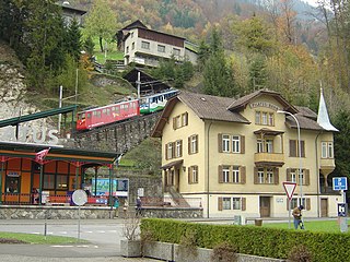
Alpnach is a village in the canton of Obwalden in Switzerland. It comprises the villages of Alpnach Dorf, Alpnachstad and Schoried.

<span class="mw-page-title-main">Giswil</span> Municipality in Obwalden, Switzerland

Giswil is a municipality in the canton of Obwalden in Switzerland.

<span class="mw-page-title-main">Lungern</span> Municipality in Obwalden, Switzerland

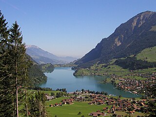
Lungern is a municipality in the canton of Obwalden in Switzerland. It encompasses Lake Lungern and, besides the village of Lungern, the settlements of Bürglen, Kaiserstuhl and Obsee.

<span class="mw-page-title-main">Engelberg</span> Municipality in Obwalden, Switzerland

Engelberg is a village resort and a municipality in the canton of Obwalden in Switzerland. Alongside the central village of Engelberg, the municipality encompasses additional settlements, including Grafenort, Oberberg and Schwand.

<span class="mw-page-title-main">Nidwalden</span> Canton of Switzerland

Nidwalden or Nidwald is one of the 26 cantons forming the Swiss Confederation. It is composed of eleven municipalities and the seat of the government and parliament is in Stans. It is traditionally considered a "half-canton", the other half being Obwalden.

<span class="mw-page-title-main">Dallenwil</span> Municipality in Nidwalden, Switzerland

Dallenwil is a municipality in the canton of Nidwalden in Switzerland.

<span class="mw-page-title-main">Stansstad</span> Municipality in Nidwalden, Switzerland

Stansstad is a municipality in the canton of Nidwalden in Switzerland.

<span class="mw-page-title-main">Wolfenschiessen</span> Municipality in Nidwalden, Switzerland

Wolfenschiessen is a village and municipality in the canton of Nidwalden in Switzerland. Besides the village of Wolfenschiessen itself, the municipality includes the settlements of Altzellen, Büren ob dem Bach, Dörfli, and Oberrickenbach, together with a large area of high alpine land, mountains, lakes, and glaciers.

<span class="mw-page-title-main">Meiringen</span> Municipality in Bern, Switzerland

Meiringen is a municipality in the Interlaken-Oberhasli administrative district in the canton of Bern in Switzerland. Besides the village of Meiringen, the municipality includes the settlements of Balm, Brünigen, Eisenbolgen, Hausen, Prasti, Sand, Stein, Unterbach, Unterheidon, Wylerli and Zaun. The municipal coat of arms shows a black eagle in a yellow field. Formerly the coat of arms of the entire Oberhasli Talschaft, this design continues the imperial coat of arms.

<span class="mw-page-title-main">Brienz</span> Place in Bern, Switzerland

Brienz is a village and municipality on the northern shore of Lake Brienz, at the foot of the Brienzer Rothorn mountain, and in the Bernese Oberland region of Switzerland. Besides the village of Brienz, the municipality includes the settlements of Kienholz and Axalp.

<span class="mw-page-title-main">Brünig railway line</span> Narrow gauge railway line in Switzerland

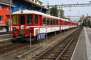
The Brünig railway line is a Swiss narrow gauge railway line that links Lucerne, in central Switzerland, with Interlaken, in the Bernese Oberland. The line runs via Alpnachstad, Giswil, Meiringen and Brienz, and passes over the Brünig Pass, using sections of rack railway to overcome the gradients, but with most of the line operated by normal adhesion methods.

<span class="mw-page-title-main">Zentralbahn</span> Swiss Railway Company

The Zentralbahn is a Swiss railway company that owns and operates two connecting railway lines in Central Switzerland and the Bernese Oberland. It was created on January 1, 2005, with the acquisition of the independently owned Luzern–Stans–Engelberg line, and the Brünig line of the Swiss Federal Railways. The company has its headquarters in Stansstad.

<span class="mw-page-title-main">Brienzwiler</span> Municipality in Bern, Switzerland

Brienzwiler is a municipality in the Interlaken-Oberhasli administrative district in the canton of Bern in Switzerland. Besides the village of Brienzwiler, the municipality also includes the settlement of Balmhof.

<span class="mw-page-title-main">Niederried bei Interlaken</span> Municipality in Bern, Switzerland

Niederried bei Interlaken is a municipality in the Interlaken-Oberhasli administrative district in the canton of Bern in Switzerland.

<span class="mw-page-title-main">Horw</span> Municipality in Lucerne, Switzerland

Horw is a municipality in the district of Lucerne in the canton of Lucerne in Switzerland.

<span class="mw-page-title-main">Hergiswil railway station</span> Station in Nidwalden, Switzerland

Hergiswil railway station is a Swiss railway station in the municipality of Hergiswil in the canton of Nidwalden. It is at the junction of the Brünig line, which links Lucerne and Interlaken, and the Luzern–Stans–Engelberg line. Both lines are of metre gauge and owned by the Zentralbahn railway company. To the south of the station the Brünig line enters the Lopper I tunnel to Alpnach whilst the Luzern–Stans–Engelberg line enters the Lopper II tunnel to Stansstad.

<span class="mw-page-title-main">Hergiswil Matt railway station</span> Station in Nidwalden, Switzerland

Hergiswil Matt railway station is a Swiss railway station in the municipality of Hergiswil in the canton of Nidwalden. It is on the Brünig line of the Zentralbahn railway company, which links Lucerne and Interlaken, and is also used by trains of the Luzern–Stans–Engelberg line.

<span class="mw-page-title-main">Kriens Mattenhof railway station</span>

Kriens Mattenhof railway station is a Swiss railway station in the municipality of Kriens in the canton of Lucerne. It is on the Brünig line of the Zentralbahn railway company, which links Lucerne and Interlaken, and is also used by trains of the Luzern–Stans–Engelberg line.

<span class="mw-page-title-main">Luzern Allmend/Messe railway station</span>

Luzern Allmend/Messe railway station is a railway station in the city of Lucerne, in the Swiss canton of Lucerne. It is located adjacent to the Swissporarena, in the south of the city. The station is on the Brünig line of the Zentralbahn railway company, and is used by trains of the Luzern–Stans–Engelberg line.

<span class="mw-page-title-main">Horw railway station</span>

Horw railway station is a Swiss railway station in the municipality of Horw in the canton of Lucerne. It is on the Brünig line of the Zentralbahn railway company, which links Lucerne and Interlaken, and is also used by trains of the Luzern–Stans–Engelberg line.

References

  1. "Arealstatistik Standard - Gemeinden nach 4 Hauptbereichen". Federal Statistical Office. Retrieved 13 January 2019.
  2. "Ständige Wohnbevölkerung nach Staatsangehörigkeitskategorie Geschlecht und Gemeinde; Provisorische Jahresergebnisse; 2018". Federal Statistical Office. 9 April 2019. Retrieved 11 April 2019.
  3. 1 2 Hergiswil in German , French and Italian in the online Historical Dictionary of Switzerland .
  4. 1 2 3 4 5 Swiss Federal Statistical Office Archived 2016-01-05 at the Wayback Machine accessed 04-Sep-2009
  5. "Ständige und nichtständige Wohnbevölkerung nach institutionellen Gliederungen, Geburtsort und Staatsangehörigkeit". bfs.admin.ch (in German). Swiss Federal Statistical Office - STAT-TAB. 31 December 2020. Retrieved 21 September 2021.
  6. Nidwalden Statistical Office-Population (in German) accessed 4 September 2009
  7. Nidwalden Statistical Office-Municipalities [ permanent dead link ](in German) accessed 4 September 2009
  8. "Luzern–Brünig–Interlaken" (PDF). Bundesamt für Verkehr. Retrieved 2013-01-07.
  9. "Luzern–Stans–Engelberg" (PDF). Bundesamt für Verkehr. Retrieved 2013-01-14.